24 Jul
Geothermal Energy prospects in India
- In news: ONGC to undertake India’s first geothermal field development project in ladakh.
- What is geothermal energy: Geothermal energy is a type of renewable energytaken from the Earth’s core. It comes from heat generated during the original formation of the planet and the radioactive decay of materials. This thermal energy is stored in rocks and fluids in the centre of the earth.
- Potential of geothermal energy in India:
India has about 10,000 MW of geothermal power potential. Rocks of India range in age from more than 4500 million years to the present day and comprise of Archean, Proterozoic, Palaeozoic, Mesozoic, Tertiary, Quaternary etc. These rocks stores geothermal energy i.e. earth's natural internal heat.
More than 300 hot spring locations have been identified by Geological survey of India with temperature ranges from 35° C to as much as 98° C.
- Benefits associated with geothermal energy:
- As growth pole in regional planning strategies, in remote and harsh terrain areas, GPP can promote regional development based on local resources.
- It can help handle environmental issues and contributes to reduced global warming effects and public health risks resulting from the use of conventional energy sources.
- It is available year-long (whereas solar and wind energy present higher variability and intermittence) and can be found around the globe.
- For India, the deployment of geothermal energy helps reduce a country’s dependence on fossil fuels.
- Geothermal power plants use a renewable resource that is not susceptible to price fluctuations.
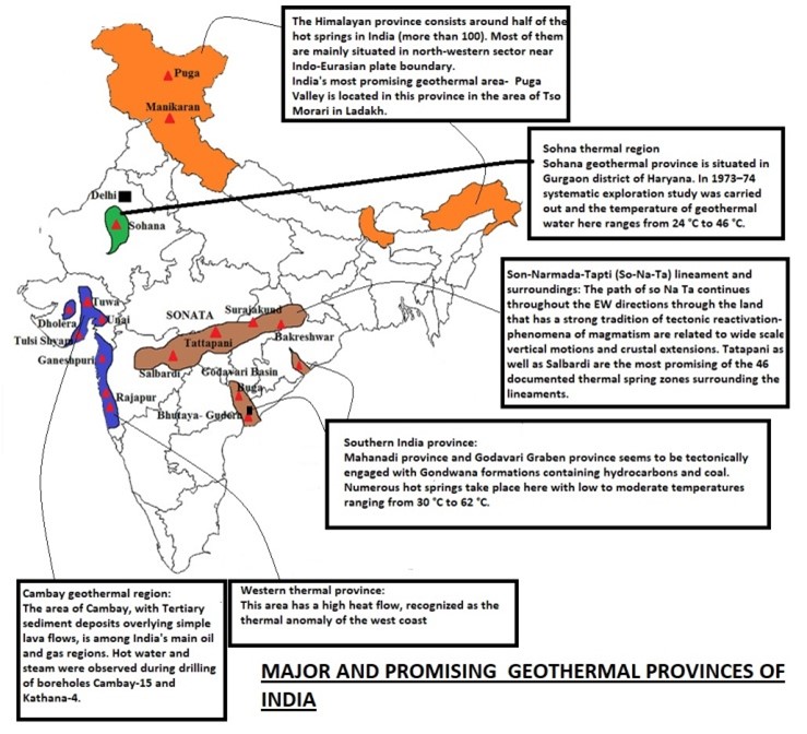
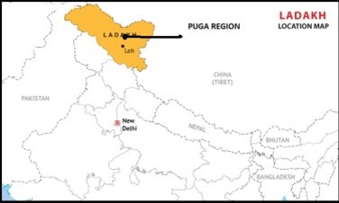
- Case study: Ladakh will get India’s first geothermal power project to tap the potential of natural geysers in Puga area
Puga is the most promising geothermal field in India, discovered in 1970s by Geological Survey of India (GSI).
Conditions like:
- high transportation cost of Conventional fuels
- poor combustion of extracted energy due to in-sufficient oxygen at high altitude
- difficult terrain
has renewed focus on geothermal perpetual form of energy for overall sustainable development of this strategically important border region.
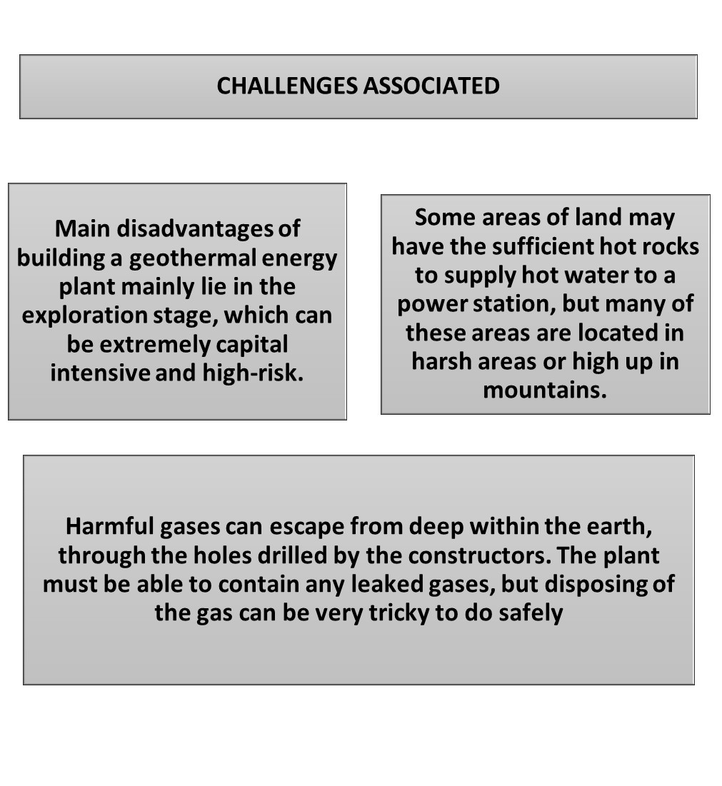
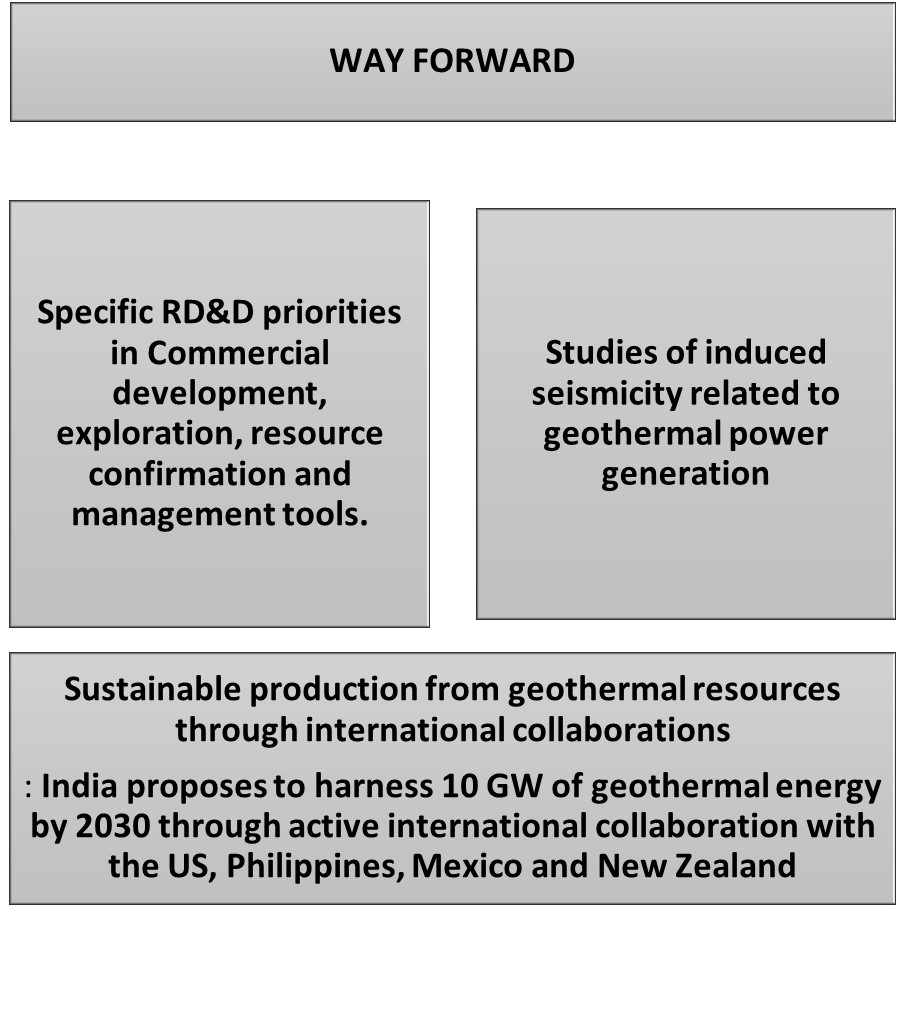
- Geothermal energy can compliment other renewable energy sources towards fulfilling India, INDC target of improving carbon emission intensity and to ensure self sufficiency of energy needs of India.
- Where can we use it:
Geography:
P1: Climatology (climate change), Environment Geo (sustainable dev), Economic Geo (Resources, Energy crises), Regional planning and development.
P2: Resources (energy), Regional planning and development, contemporary issues.
Forest Fires- A Regional Perspective
- Why in news: India has seen a drastic rise in forest fires since the start of 2021- states like Madhya Pradesh, Mizoram, Uttarakhand, and Odishawitnessed big forest fires this year, causing loss of biodiversity and livelihood.
- Background: Wildfire, also called forest, bush or vegetation fire, can be described as any uncontrolled and non-prescribed combustion or burning of plants in a natural setting such as a forest, grassland, brush land or tundra, which consumes the natural fuels and spreads based on environmental conditions (e.g., wind, topography).
- Incidences of forest fires across world:
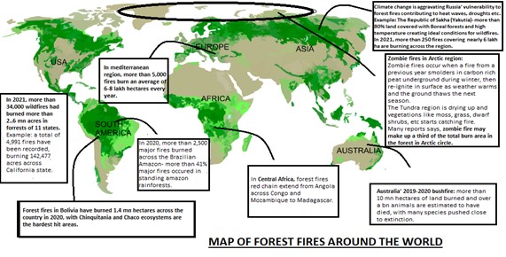
- Causes and consequences of forest fires: According to the Intergovernmental Panel on Climate Change (IPCC), climate change increases the likelihood of droughts, storms and other weather anomalies- the increase in forest fires can be attributed to the rise in temperatures due to anthropogenic climate change across world.
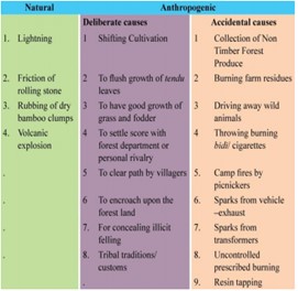
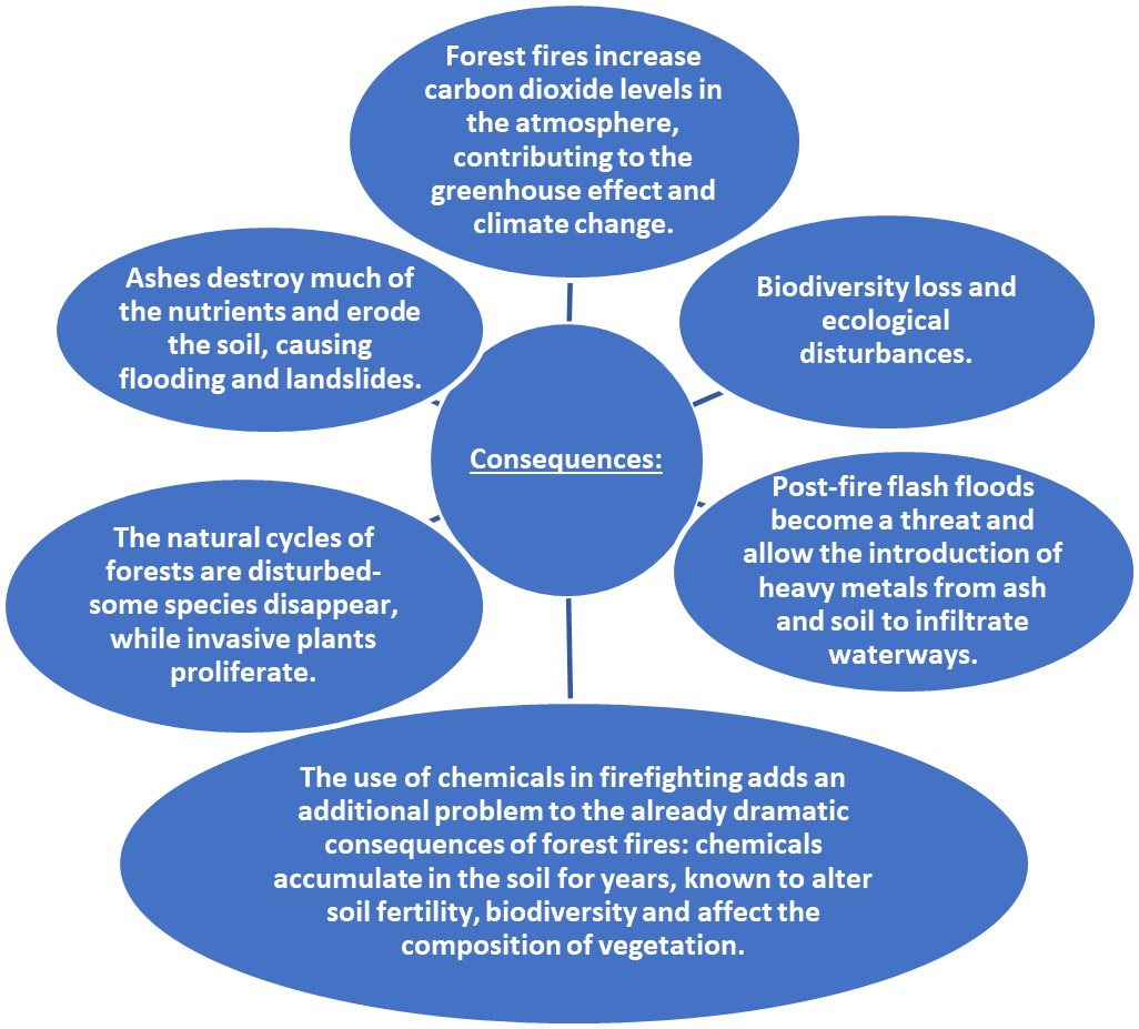
- Forest fires in India: An analysis done by the Forest Survey of India in 2019:
- Nearly 40% of forests in India are exposed to occasional fires, 7.49% to moderately frequent fires and 2.4% to high incidence levels while 35.71% of India’s forestshave not yet been exposed to fires of any real significance.
- Forests of the Northeast and central India regions are the most vulnerable areas to forest fires.
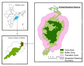
- Case study: Forest fire in Simlipal, Odisha’s Mayurbhanj district.
Generally, with the onset of summers and towards the end of autumn, area remains vulnerable to forest fires and dry, fallen leaves from shedding of deciduous forests provide a ready source of fuel for the fire. In 2021, another massive fire in Simplipal forest have affected the ecologically sensitive Simplipal Biosphere Reserve, and caused widespread damage to the local environment as well as property and livelihoods.
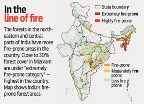
- National Disaster Management Authority (NDMA) has not recognized forest fires as natural hazards- because in India most of such fires are deliberately caused by people mainly for agricultural purposes and, therefore, it is an anthropogenic man-made hazard.
- National Action Plan on Forest Fires (NAPFF)was launched in 2018 aims to minimize forest by informing, enabling and empowering forest fringe communities and by incentivizing them to work in tandem with the forest departments.
- Where can we use it
Geography:
P1- Climatology (Climate Change), Biogeography (Soil degradation, factors influencing distribution of plants and animals, problems of deforestation, wild life), Environment Geo (influence of man on environment, regional ecological changes, ecosystem management, environ degradation, biodiversity, sustainable dev, environ hazards), Regional dev.
P2: Physical setting (natural vegetation, droughts, rainfall patterns), Resources (forest, soil), Cultural setting (tribal issues, migration), Regional planning and development.
Rural- Urban Fringe
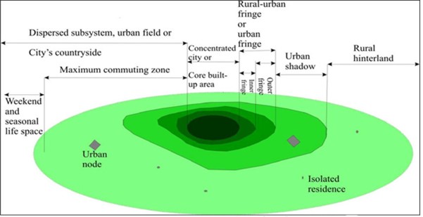
- It is a zone of transition between the continuously built-up urban and suburban areas of the central city and the rural hinterland.
- It can be formally defined as “the area of transition between-recognized urban land use and the area devoted to agriculture.”
- It's a manmade version of the "edge effect", which in the natural world is the juxtaposition of two contrasting environments or ecosystems.
Characteristics:
- Common land-uses: Airports, golf course, horse-race, sewage treatment plants, large sized godowns and farm houses.
- Intensive land use , arable land is devoted to perishable commodities.
- Encroachment of residential and industrial estates.
- Small farm holdings.
- Inadequate social amenities and public utility facilities.
Sinking Creek
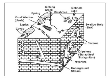
- Sinking creek is a type of karst landform. There is presence of numerous closely-spaced small sink-holes on the karst plain.These sink holes act as funnels because surface water disappears to go underground through these holes. When surface water disappears through numerous sinkholes located in a line, the resultant feature is called sinking creek.
- The point through which water goes downward, is called ‘sink’.
- The water of short rivers disappears through a single ‘sink’ while that of large streams disappears through many sinks.
- Characteristics: The elevation near the mouth of Sinking Creek is 350 m above sea level. The elevation of the creek's source is approximately 500 m above sea level. The conditions that promote creek development are dense limestone near the surface; a moderate to heavy rainfall; and good groundwater circulation.
Sinking Creeks-Karst Landforms
Sinking Creek across globe: The Virginia South-eastern state of USA has presence of many sinking creeks. Even some creeks are million years old. Another example of sinking creeks is in Slovenia (East Europe).
Biomass Towns: Japan
Background: The Fukushima accident has pushed Japan to further develop its renewables initiative, particularly the biomass energy commodity. Their projection for the 2030 energy mix includes a biomass share of 4%. Further, a policy was introduced in 2002 called the Biomass Nippon Strategy. This was revised in 2006, fortifying the creation of Biomass Towns.

How biomass is utilized in the biomass towns of Japan under its Biomass Nippon Strategy?

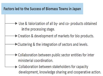
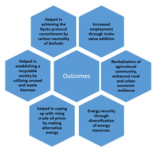
The Japanese Biomass Town Plan model has been applied in other four countries (Indonesia, Malaysia, Thailand and Vietnam) in the ASEAN through a supporting ministry in these countries. This can be replicated in India also which is having high potential of biomass about 500 metric tons per year availability.
Where this Case Study can be used?
This case study can be used in topics related to GS3 (Renewable Energy, Sustainable Development, Inclusive Growth), Optional Paper 1 (Sustainable Development, Energy Crisis, Regional development strategies), Optional Paper 2 (Biotic resources, Energy Crisis, Integrated rural development, Tribal area development, Sustainable growth).
Tors
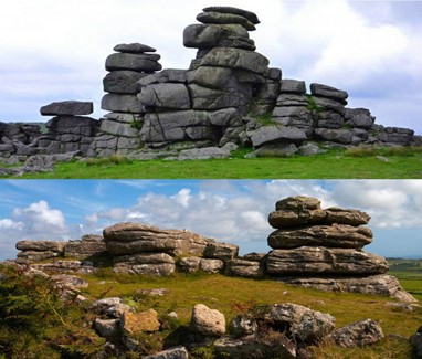
- Tors, one of the most controversial landforms, are piles of broken and exposed masses of hard rocks having a crown of rock blocks of different sizes on the top and clitters (trains of blocks) on the sides.
- Characteristics: The rock blocks, main components of tors, may be cuboidal, rounded, angular, enlarged etc. in shape. They may be seated at the top of the hills, on the flanks of the hills or on flat basal platforms ranging from 6m to 30m in height.
- Where are they found? They are found in different climates varying from cold to hot and dry to humid. Though tors have developed over almost all types of rocks but they are frequently found in the regions of granites.
- How are they formed? Various theories have been put forth to explain the formation of tors, but there is no unanimity among them because tors are not confined to a particular rock type and climate. For example 1) in periglacial areas tors are formed due to weathering of rocks along the joints through the process of Congelifraction and removal of weathered materials through Congelifluction (i.e. Periglacial theory by J. Palmer). 2) Tors in the Bohemian uplands are formed due to two processes i.e. frost weathering and removal of weathered material operating together (i.e. Two stage theory by Demak).
- Tors in India: In India tors have been found over granites (Chotanagpur highlands i.e. Palamau upland, Ranchi plateau, Singhbhum area etc.), basalts (Deccan plateau), sandstones (Rhotas plateau, Rewa plateau, JNU campus) etc.
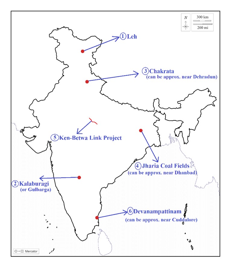
Places in news
|
Leh:
|
|
Kalaburagi:
|
|
Chakrata:
|
|
Jharia Coal fields:
|
|
Ken-Betwa Link Project:
|
|
Devanampattinam:
|
Share the article
Get Latest Updates on Offers, Event dates, and free Mentorship sessions.

Get in touch with our Expert Academic Counsellors 👋
FAQs
Geography Current Affairs focuses on the contemporary issues, events, and developments in the field of geography. It covers recent geographical phenomena, environmental changes, geopolitical shifts, and related news. This differs from regular geography studies which may focus more on foundational concepts, historical contexts, and theoretical frameworks.
Updates are provided regularly to ensure that subscribers stay informed about the latest developments in geography. Typically, updates are provided on a fortnightly basis, depending on the frequency of significant events and changes in the field.
Absolutely. Geography Current Affairs serves as a valuable resource not only for Geography optional but also for GS papers, especially GS Paper 1 (covering Indian Heritage and Culture, History, and Geography of the World and Society) and GS Paper 3 (covering Technology, Economic Development, Biodiversity, Environment, Security, and Disaster Management). It aids in building a holistic understanding of various topics and strengthens answer-writing skills by incorporating contemporary examples and perspectives.
Geography Current Affairs holds immense importance for UPSC preparation, particularly for aspirants opting for Geography optional. It helps candidates stay updated with the latest developments, geographical phenomena, environmental issues, and geopolitical shifts worldwide, aligning them with the dynamic nature of the subject as tested in the UPSC examinations.

