25 Sep
Ozone Hole Recovery-Lessons from Montreal Protocol for addressing Climate Change
- In news: India recently decided to ratify a key amendment to the 1989 ozone-saving Montreal Protocol –The Kigali Agreement.
- Background:
- The Montreal Protocol is an international environmental agreement with universal ratification, adopted in 1987 to protect the ozone layer by eliminating use of ozone depleting substances (ODS).
- With the full and sustained implementation of the Montreal Protocol, the ozone layer is projected to recover by the middle of 21st century. According to Scientific Assessment of Ozone Depletion, 2018, the ozone layer has recovered at a rate of 1-3% per decade since 2000.
- The Montreal Protocol has been successful in reducing ozone-depleting substances and reactive chlorine and bromine in the stratosphere- have phased out 98% of ODS globally compared to 1990 levels. As a result, the ozone layer is showing the signs of recovery. It is expected that the ozone layer will return to pre-1980s levels by the middle of the century and the Antarctic ozone hole by around 2060s.
- The Montreal Protocol is one of the most successful international environmental agreements to date. The lessons learned from the Montreal Protocol should be used as guidance to formulate a more effective and successful international response to climate change.
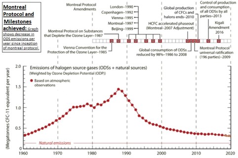
- Reasons behind greater success of Montreal protocol than other agreements related to climate change:

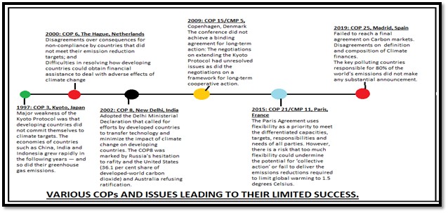
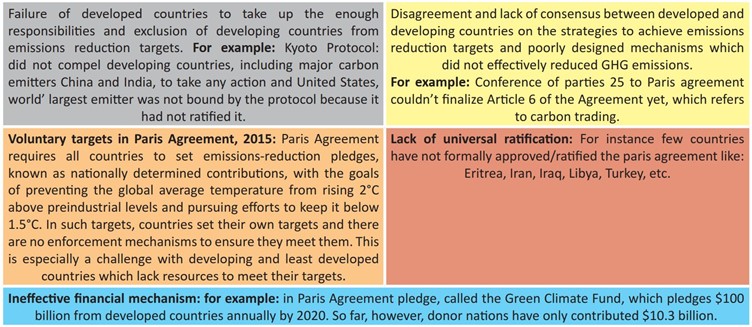
- Limitations of other international treaties that led to their partial success:
- Lessons from Montreal protocol that can be implemented in other international agreements:
- Sectoral approach could be applied to climate change- a coordinated effort that divides the climate problem into sectors can encourage faster learning. The Montreal Protocol benefited from being a focused sectoral agreement. This allowed the scientists, technologists, and policymakers to learn faster, the technology to develop faster and for scientists, businesses and policymakers to gain confidence to do more and more.”
- Common but differentiated responsibilities in addressing issues of financing and technology transfer: Under this, all parties have specific responsibilities related to the phase out of the different groups of ODS, control of ODS trade, annual reporting, national licensing systems to control ODS imports and exports, and other. Developing and developed countries have equal but differentiated responsibilities, but most importantly, both groups of countries have binding, time-targeted and measurable commitments.
- A key feature of the Protocol was the creation of a multilateral fund to implement technology transfer and financial funding to help developing countries phase out their use of ozone depleting substances (ODSs). It operates under the authority of parties to the treaty and the equality of voting power between donors and recipients.
- Periodic review and replenishment of climate finance: Montreal protocol’ multilateral Fund was renewed periodically that paid developing countries and developing country industries to make the switches to the new generations of chemicals. Financial commitments were agreed upon for three year periods based on an assessment of what recipient countries were prepared to do to reduce their use of ODSs. These short-term assessments guided the Ozone Fund, as opposed to more speculative, long-term estimates of total costs.
- Public support generated by scientists-turned-advocates: That advocacy must be present to reduce some of the most devastating effects of global warming. In Montreal protocol, because of their advocacy, people began boycotting bug sprays, hairsprays and other spray cans that propelled these ozone-depleting chemicals into the atmosphere. One can already see the changes in climate change efforts where the Intergovernmental Panel on Climate Change (IPCC), acting more and more like advocates with each new terrifying report.
- Common concern and Precautionary principle -Montreal Protocol worked because an international committee assembled and solved the issue with the urgency the crisis demanded. It is important, because it avoids far bigger, longer, more expensive and potentially more damaging consequences that can arise by postponing action.
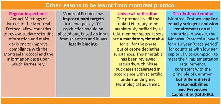
The Montreal Protocol was a revolutionary international legal and environmental agreement. It has bridged the north-south divide better than perhaps any other treaty. It has helped spread ozone- safe technology around the world and just as important are the effects this treaty has had in combating climate change. From 1989–2013, the protocol’s ban on certain chemicals reduced cumulative CO2-equivalent emissions by 135 billion tons.
- Where it can be used:
Paper1: Climatology (Climate Change), Economic Geography (Limits to Growth), Regional Planning.
Paper2: Regional planning and development, Contemporary issues.
GS: Paper1 (Features of world’ geography).
Paper 3 (Environment-climate change)
Geostrategic importance of Indo-Pacific region for India
Why in News? - The launch of the EU’s strategy for the Indo-Pacific marks the beginning of a new approach to the region.
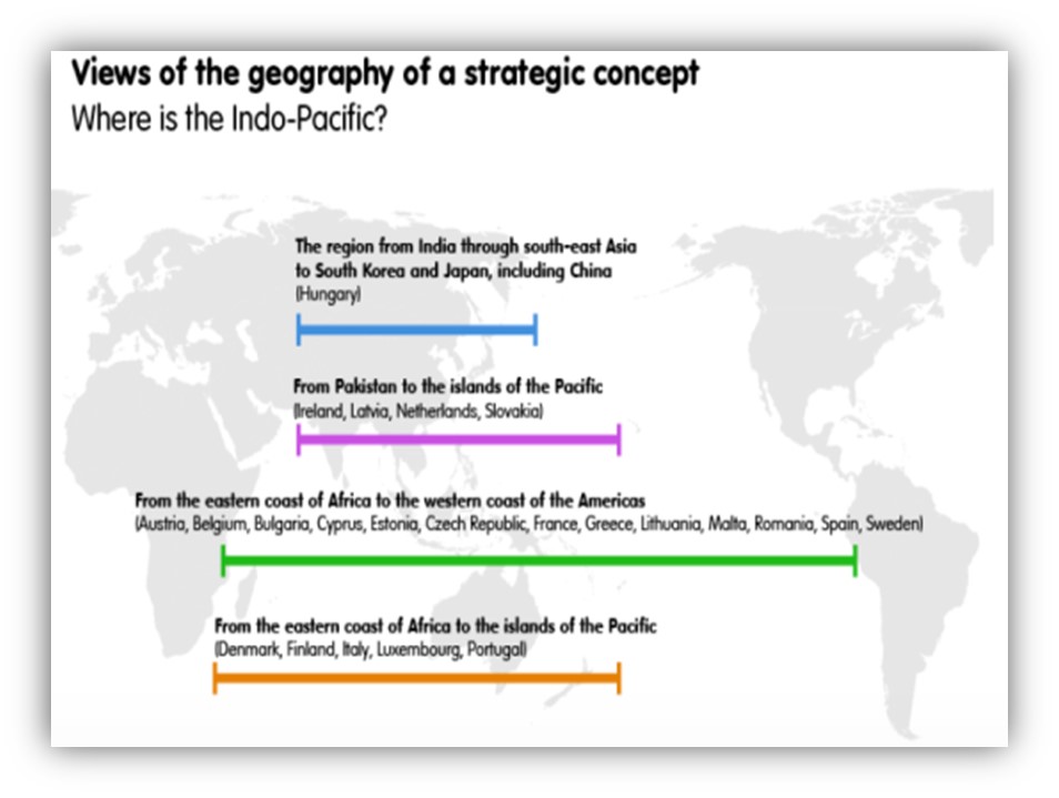
The idea of Indo-Pacific: Itrefers to the Indian and the Pacific Oceans between the east coast of Africa and the American west coast and their several littoral countries.However, US consider Indo-Pacific from west coast of India to the west coast of the United States while India looks at it as a wider region, which extends to West Asia and the east coast of Africa (eastern coast of Africa to Oceania).
Strategic significance of Indo-Pacific region for India:
- Strategic significance: Indio-Pacific is a multipolar region, contributing more than half of the world’s GDP and population. A stable, secure and prosperous Indo-Pacific Region is an important pillar of India’s strategic partnership with the other countries especially USA.
- Mineral Resources: Maritime territories have also emerged as depositories of vital resources ranging from fish stocks to minerals and offshore oil and gas.48 The South China Sea, for instance, is estimated to hold some 10 per cent of the global catch of fish as well as 11 billion barrels of oil and 190 trillion cubic feet (tcf) of gas.
- Economic Growth: According to a report of the Asian Development Bank (ADB), countries in the Indo-Pacific produce over 60% of global GDP, making the region the largest single contributor to global growth.
- Commerce: The region consists of many of the world’s vital choke points for global commerce, including the Straits of Malacca which is very critical for the growth of world economy. The Indo-Pacific region also stands at the intersection of international trade, with around 32.2 million barrels of crude oil pass through annually and 40% of global exports come from the region.
- Maritime Trade: Pacific islands are strategically significant from New Delhi’s point of view as they sit astride important sea lines of communication through which important maritime trade is conducted.
General strategic importance of Indo-Pacific littorals has increased due to the following reasons:
- US’s pivot to Asia: In order to counter China’s rise, the US is rebalancing its foreign policy and giving more importance to Asia. That has increased the importance of Indo-Pacific region.
- Trans Pacific Partnership (TPP): TPP is a major Free Trade Agreement backed by the US which will bind the region in a tight economic embrace.
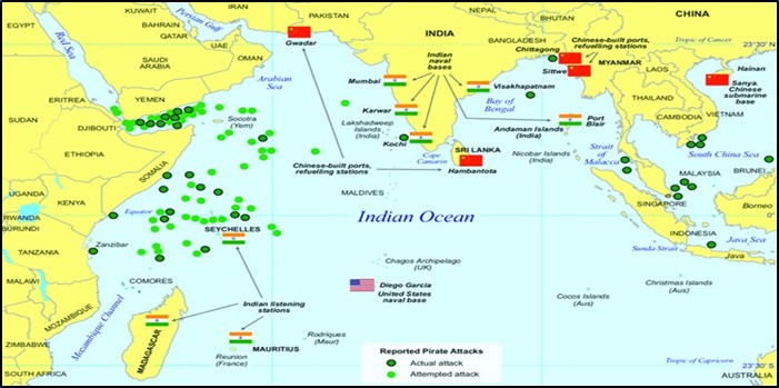
- Sea Lines of Communications: This region contains very important SLOCs which have a direct bearing on the economic security of many nations. SLOCs through which nearly 55% of Indian trade passes through. This makes it strategically imperative for us to safeguard our maritime interests.
- South China Sea Resources: There are indications of presence of hydrocarbon assets in the South China Sea Region. This increases the importance of this region manifold. China’s increasing assertiveness in SCS will not only devoid us of mineral (oil etc.), marine, rare earth metals and other resources (important for energy and food security) but China’s naval/military presence in SCS will reduce our strategic edge in our backyard (IOR).
- China’s ‘Blue Water’ Ambitions: In order to stake claim to disputed area of the South China Sea as well as safeguard its SLOCs, China has rapidly expanded its navy. This poses a strategic threat to India and other littorals in the region.
- In the wake of slowing down of EU and U.S economy (especially after 2008 Recession + covid-19 led downfall Of the economy), focus has shifted towards Indo-pacific littorals as it houses many of the world’s biggest economies and largest markets.
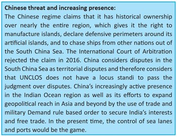
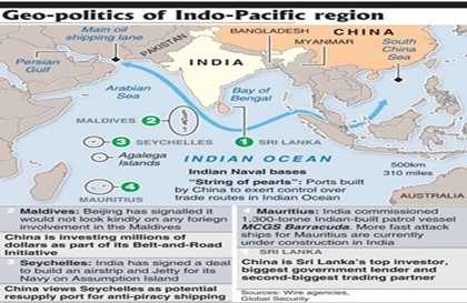
Figure 2: Nature of emerging regional order in the Indo-Pacific
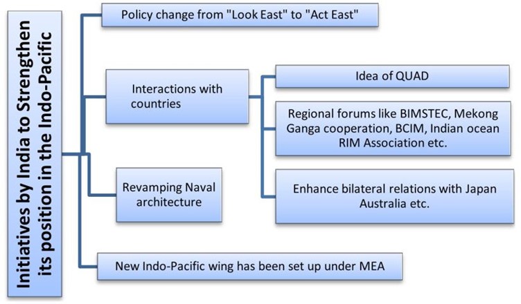
Indo Pacific is a strategic space which offers a number of challenges and opportunities for India and all other stakeholders. Appropriate diplomatic manoeuvring and economic and military assertion is vital for the implementation of India’s interests in the region along with leveraging the space as a building block for a multipolar world order.
Where it can be used?
Paper1: Oceanography (Marine resources), Economic geo (world resources, LTG), Paper2: Resources, Political geography, contemporary issues, GS: GS2- Regional and Global Groupings and Agreements involving India and/or affecting India’s interests.
Human Wildlife Conflict (HWC) - What is the road ahead?
Why in news: A report, titled“A future for all - the need for human-wildlife coexistence” by WWF and UNEP, highlighted that HWC is one of greatest threats to the long-term survival of wildlife species. Also the recent spike of elephant deaths in Kodagu.
Important findings from the report:
- HWC related killing affects more than 75% of the global wild cat species, as well as many other terrestrial and marine carnivore species such as polar bears and Mediterranean monk seals, and large herbivores such as elephants.
- Global wildlife populations have fallen an average of 68 per cent since 1970, HWC in combination with other threats, has driven the significant decline of species that were once abundant and species that are naturally less abundant, have been pushed to the brink of extinction.
- India will bemost-affected by HWC as it had the world’s second-largest human population as well as large populations of tigers, Asian elephants, one-horned rhinos, Asiatic lions and other species.
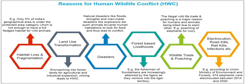
Measures for the mitigation of Human Wildlife Conflicts:
- Land Use Planning: Ensuring that both humans and animals have the space they need is possible. Protecting key areas for wildlife, creating buffer zones and biosphere reserves.
- Community based natural management: If people are empowered to manage their relationship with wild animals, there will be reduced economic, human and wildlife losses due to HWC.

- Fencing: Fences can be setup in areas that witness high HWCs to restrict the entry of wild animals into human habitations. g.Nylon fencing on Sundarbans Islands prevents tigers from swimming across to inhabited islands.
- Culling Invasive Species: Culling and trapping of invasive and nuisance species that spread diseases or damage crops or livestock. g. in Himachal Pradesh, Rhesus Macaques were declared as vermin and open to be trapped and killed due to their damage to crops.
- Environmental Impact Assessment: This can ensure that infrastructure activities do not take place in core wildlife areas.
- Buzzer and alarms: This can keep animals away from potential conflict sights like road and railway tracks. g. Plan BEE, a unique initiative by the Northeast Frontier Railway (NFR) to keep wild elephants away from railway tracks through use of buzzers imitating bees.
- Eco Bridges: They are wildlife corridors also known as wildlife crossings that are a link of wildlife habitat which connects two larger areas of similar wildlife habitat. g. Introduced in Tadba-Andheri and Uttarakhand.
- Awareness programs: To sensitize the people about the Do’s and Don’ts to minimize Human Wildlife conflicts.
- Restricting transport in high animal densities: This can prevent road kills and also car accidents due to oncoming animal traffic. g. Bandipur National Park shuts down traffic at night.
Global initiatives for the mitigation of HWCs:
- Global Wildlife Program: It’s a global partnership led by the World Bank that promotes wildlife conservation and sustainable development by combatting illicit trafficking of wildlife.

Initiatives by the Government of India for the mitigation of HWCs:
- Advisory for Management of Human-Wildlife Conflict:
- Empower Gram Panchayats: The advisory envisages empowering gram panchayats in dealing with the problematic wild animals.
- Preventive Measures: Adoption of early warning systems, creation of barriers, dedicated circle wise control rooms with toll-free hotline numbers.
- Crop Insurance: Adding a crop damage due to animal component in PMFBY.
- National Wildlife Action Plan (2002-2016): It sought to provide protection to wildlife in multiple-use areas such as farm lands, wastelands, wetlands, coastal habitats, by re-establishing natural wildlife corridors and linking the protected areas.
- In some regions, wild species if captured, are handed to forest officials which has saved their numbers form declining. g. Snow leopards of Himachal Pradesh.
Way Forward:
- Most of the SDGs have links to HWC, for example: SDG #2: Zero Hunger. Link: Wildlife damages food stores, crops, and livestock and puts subsistence farmers at risk of hunger. According to WWF, “if the world is to have a chance of meeting the SDGs by 2030 deadline, HWC must be explicitly included in SDG implementation plans, as well as at the heart of the convention on Biodiversity’s new framework”.
- Completely eradicating HWC is not possible but well-planned, integrated approaches can reduce conflicts and lead to a form of coexistence between people & animals.
Where it can be used?
This can be used in topics related to Paper 1 (Biodiversity and Sustainable development, Problems of Urbanization), Paper 2(Changes in patterns of land use, Problems of urbanization, Sustainable development) and GS3 (Biodiversity).
Central Business District
About:
- It is the nucleus of an urban area that contains the main concentration of commercial land use.
- It is the most accessible point in the urban area and its peak land value.
Characteristics:
- The most expensive land in the city – this is called the ‘Peak Land Value Intersection’
- Tall buildings (to maximise the rent for the land)
- High density of shops and offices
- High pedestrian ‘footfall’
- Traffic congestion and traffic calming measures, including pedestrianised streets
- Important administrative and cultural buildings such as government offices and concert halls
- Public transport points such as bus stops, metro stations and taxi ranks
- The region is often referred to as the Dead Heart post working hours, as these are only commercial zone.
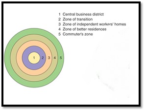
Some associated models:
- The Concentric Zone Model by E.W. Burgess
- The Wedge or Sectoral Model by Homer Hoyt
- The Multiple Nuclei Model by C.D. Harris and E.L.Ullman
CBDs in India:
- Characteristics of CBD in India:

Majority of the CBD’s are facing future threat due to uncontrolled expansion of the core into the greenbelt zone, esp.:
- Bangalore, Karnataka
- Connaught Place, New Delhi
- Pg 151, Hussain Majid, Models in Geography.
Atlantic Multidecadal Variability
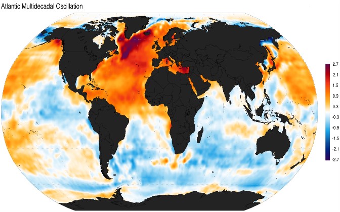
The Atlantic multi-decadal variability (AMV, also known as Atlantic multi-decadal Oscillation, AMO), is a North Atlantic basin-wide sea surface temperature (SST) fluctuation on multi-decadal time scales.
- Positive Phase of AMO and its Impacts
Typically AMO alternates between phases of Warm and Cool ocean waters in the Northern Atlantic over a period of approximately 70 years.
It is associated with warmer than average Sea Surface Temperature across much of Northern Atlantic Ocean and cooler Southern Atlantic.
Atlantic multi-decadal oscillation spatial pattern obtained as the regression of monthly sea surface temperature anomalies (1870-2013).
Impacts:
- Increased Hurricanes: availability of energy due to warmer waters.
- Wetter summers across Europe.
- Heavy Rainfall in Sahel.
- Droughts in North- East Brazil.
- Reduction in Sea Ice in Arctic
- Wetter Indian Monsoon.
- Negative Phase of AMO and its Impacts
Impacts:Associated with Cooler Sea Surface Temperature in the Northern Atlantic and warmer temperatures in the southern Atlantic.
The effects are opposite as seen in positive phase. Eg. Severe Droughts in SAHEL.
The Patterns observed in the Recent Past:
Warm Phase: 1925-1965
Cool Phase: 1965-1995
From 1995 till now – AMO is positive, However the positive AMO has also been linked with changes in emission of pollution the last two decades.
Roches moutonnées
About:
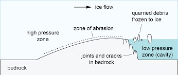
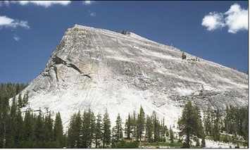
- Rounded rock hummocks, asymmetrical hillocks, mounds or hills having one side smoothly moulded with gentle slope and the other side steepened and craggy lee.
- The term was first used by de Saussure in 1804.
- Nature of the past glacier systems can be inferred where such landforms are found.
Formation:
- Forms as a result of stress differences over the bedrock surface.
- High normal stress on the stoss face results in bedrock abrasion,
- Lower normal stresseson the lee face often allow a cavity to form, which promotes quarrying of bedrock along lines of existing weakness
Found in:
- Castle Loch, southwest Scotland
- Goldbergkees glacier, Austria
- Glaciated valleys of Kashmir Himalaya, etc.
Addressing Urban Climate Challenges: Barcelona
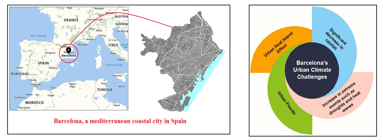
Measures taken by Barcelona to address it urban climate challenges:
- Barcelona Green Infrastructure and Biodiversity Plan (BGIBP), 2020
- Aim: It’s an umbrella strategy to secure a city model where nature and urbanity interact and enhance one another to make the city more resilient and adopted to climate change.
- Components: Building green infrastructure across the city such as planting a network of street trees, urban green corridors, urban gardens and constructing urban hybrid dunes on heavily used beaches to optimize the flow of ecosystem services.
- Tree Master Plan for 2017-37: It is in line with the BGIBP 2020.
- Aim: To expand tree coverage across the city and improve the climate resilience of urban trees.
- Components: Selection of tree species that are more resilient to water and heat stresses, diversification of tree species, increased use of runoff water for watering trees, automatic irrigation and control of water leaks.
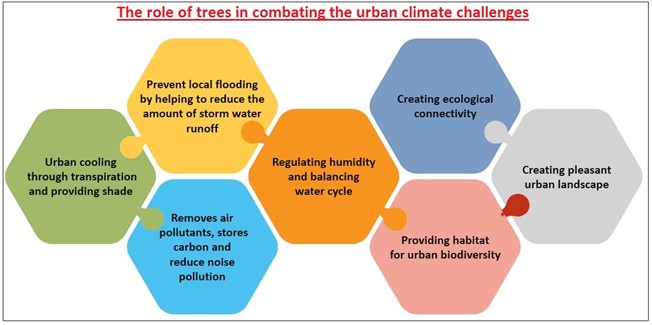
By addressing the above urban climate challenges, Barcelona has committed to becoming a global model of a sustainable city. This can be replicated for Indian cities which are facing similar urban climate challenges such as New Delhi and Hyderabad.
Where it can be used?
This case study can be used in topics related to Paper 1 (Urban climate, Problems of urbanization, Sustainable cities), Paper 2 (Urban Floods, Problems of Urbanization) and GS 1 (Problems of urbanization).
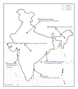
Places in news - Chandaka Wildlife Sanctuary
|
Chandaka Wildlife Sanctuary
|
|
Bor Tiger Reserve
|
|
Ennore
|
|
Golaghat
|
|
Bandhwari Village
|
|
Karjan Dam
|
Share the article
Get Latest Updates on Offers, Event dates, and free Mentorship sessions.

Get in touch with our Expert Academic Counsellors 👋
FAQs
Geography Current Affairs focuses on the contemporary issues, events, and developments in the field of geography. It covers recent geographical phenomena, environmental changes, geopolitical shifts, and related news. This differs from regular geography studies which may focus more on foundational concepts, historical contexts, and theoretical frameworks.
Updates are provided regularly to ensure that subscribers stay informed about the latest developments in geography. Typically, updates are provided on a fortnightly basis, depending on the frequency of significant events and changes in the field.
Absolutely. Geography Current Affairs serves as a valuable resource not only for Geography optional but also for GS papers, especially GS Paper 1 (covering Indian Heritage and Culture, History, and Geography of the World and Society) and GS Paper 3 (covering Technology, Economic Development, Biodiversity, Environment, Security, and Disaster Management). It aids in building a holistic understanding of various topics and strengthens answer-writing skills by incorporating contemporary examples and perspectives.
Geography Current Affairs holds immense importance for UPSC preparation, particularly for aspirants opting for Geography optional. It helps candidates stay updated with the latest developments, geographical phenomena, environmental issues, and geopolitical shifts worldwide, aligning them with the dynamic nature of the subject as tested in the UPSC examinations.

