14 Aug
Urban floods- removing the bottlenecks
In News
Various cities across the world have been undergoing flooding, e.g., city of Zhengzhou in China, Mumbai in India etc.
Introduction
- Urban flooding is a serious and growing development challenge. Floods affect urban settlements of all types, from mid-sized market towns and service centers, for example along the Indus River, to the major cities, megacities and metropolitan areas like Sendai, Brisbane, New York, Shanghai, Delhi, and Bangkok. Cities/towns located on the coast, on river banks, upstream/ downstream of dams, inland cities and in hilly areas can all be affected.
- The hazards and observed effects vary: regular seasonal river swelling, intense rainfall flash flooding, groundwater flooding, coastal storms, coastal erosion, and subsidence. Moreover, global climate change is resulting in changed weather patterns and increased episodes of high intensity rainfall events occurring in shorter periods of time. Then the threat of sea-level rise is also looming large, threatening all the coastal cities.
- Urban flooding can become increasingly costly, as low- and middle-income countries urbanize. This large and evolving challenge means that far more needs to be done by policy makers to better understand and more effectively manage existing and future risks of urban floods.
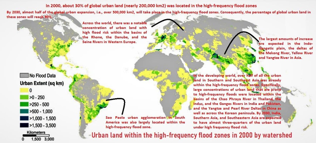
Urban Areas with high-frequency floods
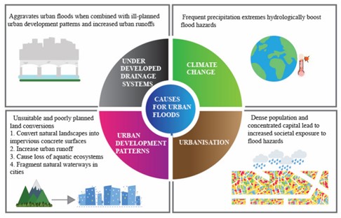
How urban floods differ from rural floods?
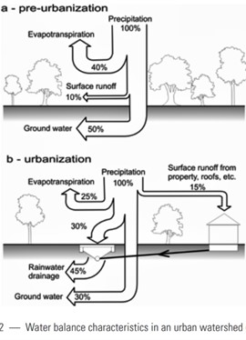
At the most basic level, land cover and vegetation are stripped away in the process of urbanization to make way for buildings, roads, parking lots, and other impervious structures. The natural storage capacity of the soil in the area is diminished or even eliminated. Constructed (and inadvertent) drainage channels alter the existing hydrology and flow regimes, such that precipitation flows rapidly across the surface in short, intense, high-volume bursts rather than sinking into the soil. Adjacent Figure illustrates this difference in the flow of urban precipitation.
Impacts of Urban Floods :
- The direct impacts of urban flooding: Inundation of buildings and residences, damage to structures, washing away of belongings and vehicles, destruction of public infrastructure, mudflow, the injuries and loss of life, untreated sewageand toxic chemicals can pose significant threats to public health and the water supply.
- Other impacts are often overlooked in planning for, responding to and recovering from urban floods. The ability to earn a livelihood may disappear for some time. Schools and other community centers or services may be closed for days or weeks, and commercial businesses that provide food and necessary items may be damaged or inaccessible.
Addressing the Challenges of Urban Floods
Flood management measures are typically described as either structural or non-structural. Structural measures aim to reduce flood risk by controlling the flow of water both outside and within urban settlements. They are complementary to non-structural measures that intend to keep people safe from flooding through better planning and management of urban development. A comprehensive integrated strategy should be linked to existing urban planning and management policy and practices.
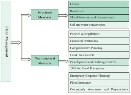
Both the structural and non-structural measures can be implemented under following broad geographical perspectives-
- Regional Planning Approach: Every region has its unique challenges in regards to the urban flooding and hence requires specialized mechanisms to deal with it. Cities may be situated on the coasts, river banks, near downstream/ upstream of dams, inland or in hilly areas. Hence, we need to map the reasons for each of these categories and plan
- Coastal Cities: Coastal cities/towns, which are located on the coastline, experience flooding due to localized rainfall, storm surges caused by cyclones. They also get affected by high tides, coinciding with localized rains.
- Cities on Major Rivers: Many cities/towns are located on the banks of small and big rivers. Floods in those rivers cause inundation of the flood plains as very often urban growth has indiscriminately spread into flood plains, reducing the area into which floods can naturally overflow.
- Cities near Dams/Reservoirs: There are cities/towns which are located along a river, either downstream or upstream of dams/ reservoirs. Those located downstream of reservoirs can get flooded by release of water in excess quantities. Sometimes cities/towns located upstream of a dam/reservoir also get affected by rising level of backwaters when release of water is sometimes withheld during the flood season.
- Inland Cities: Cities/towns located inland can experience floods largely because of localized heavy rainfall within the watershed due to overwhelming of the storm water drainage system capacity.
- Cities in Hilly Areas: Cities/towns located in the hilly areas experience flash floods. The reasons for flash floods can be cloud burst, that is, intense rainfall, the outburst of a landslide dam lake, the failure of artificial dam, or a glacial lake outburst.
- Applications of Applied Geography: The city specific reasons need to be addressed utilizing knowledge of geomorphology (Applied geomorphology) and climatology (Applied climatology) to implement the structural and non-structural measures.
- Applied geomorphology in controlling floods: slope management for effective drainage, floodplain management, river channel management, geohydrological understanding of city terrain, slope stability in hilly regions, prediction of glacial lake outburst floods, coastal management etc.
- Applied climatology in controlling floods: Effective forecasting of weather, incorporating emerging challenges of climate change, consideration of heat island effects in rainfall variation etc
- Micro-Climate and Urban Heat Island Effect- While general weather systems cover extensive areas, micro-climate in urban areas has great relevance for urban flood management. It has been observed that there is a significantly higher rainfall recorded over many urban areas over the years. Apparently, the urban heat island effect is responsible for this.
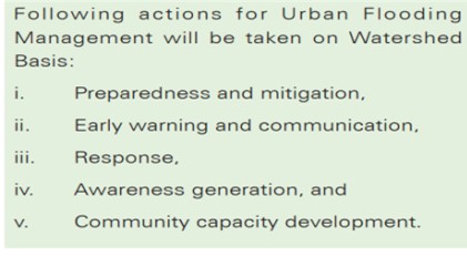
- Watershed as Basis for Management of Urban Flooding: Urban areas comprise of natural watersheds, which, in turn, are made up of smaller catchments. The entire watershed, however, drains into a single water body like lake or river. While catchment can be the basis for the purpose of designing stormwater drainage system, any planning for effective urban flood management has to take into the consideration the entire watershed. As per India’s National Guidelines on Management of Urban Flooding, following should be done (refer to adjacent infographic).
-
- Ecosystem Approach to prevent and Mitigate Urban Flooding: Create a 'sponge city': This concept has become very popular in China, a country that has seen the rate of urban flooding more than double in recent years. “A sponge city is one that can hold, clean, and drain water in a natural way - using an ecological approach.” So, rather than funneling rainwater away, a sponge city retains it for its own use, within its own boundaries. The uses include: irrigating gardens and urban farms, recharging depleted aquifers, replacing or replenishing the water used to flush toilets, and processing it so that it can be clean enough to use as drinking water.
- Risk Hazard Mapping- Reducing Vulnerability: Vulnerabilities are generally due to the geographical features of an area, meteorological phenomenon, unsafe conditions that are developed by human actions or inactions. So, it is essential to identify the root causes of these vulnerabilities, specific to an area under consideration in order to mitigate the causes rather than the consequences.
- Decentralized Flood Management- Participatory Planning: Traditionally, flood control has been driven by top-down decision making. Following the hierarchical structure of administrative systems, flood control measures are planned without the participation of the affected communities and other stakeholders. These shortcomings can be overcome by establishing participatory planning process as a basic principle in urban flood risk management. In this context, decision-making is understood as a combination of top-down and bottom-up approaches which enables the involvement of all stakeholders on the basis of equity.

- Addressing climate change in developing flood management strategies: measuring climate disaster resilience of cities: Flood risk management schemes should take into account climate variability and long term impacts of climate change. A comprehensive risk reduction approach should consider issues related to hazards, vulnerability and exposure not only in the present context but also in potential future scenarios.
- Techno-Legal Regime
- Legal Support for Planned Development of Urban Areas: Master Planning, Zonal Planning, Development Country Regulations and Building byelaws provide the mandatory techno-legal framework for regulating the built environment. For instance, heavy rainfall in July 2011 prompted the city of Copenhagen to develop a Cloudburst Management Plan in 2012 to prepare the city for one of the biggest climate change challenges — extreme rainfall and pluvial flooding.
- Urban Sprawl: Growth of urban sprawls result in change in land-use and land cover with impacts such as loss of agricultural land, open space, and ecologically sensitive habitats. This will ultimately have future implications in terms of urban flooding. All such concerns will be addressed by the governments on a priority basis.
Urban flood management – especially in the context of climate change and associated extreme weather events – works best when it is integrated into efforts by the entire community at adapting to the likely effects of climate change. There are a number of factors – inherent characteristics of the community and the government – that can place bounds on the possibilities for success in urban flood management and adaptation. With the significance of climate change and population growth facing urban cities, there is a critical need to allocate investments in sustainable development solutions. The framework for ‘Transitioning towards water sensitive cities’ offers a tool for urban development planners to identify critical areas of risks and attributes, where investments can be better utilized for capacity development, institutional reforms and structural interventions which could contribute to deliver sustainable urban water management leading to flood resilient cities.
References
- https://www.unescap.org/sites/default/files/Water_Resources_Series_No86.pdf
- https://www.worldbank.org/en/news/feature/2016/02/23/drmhubtokyo-knowledge-program-integrated-urban-flood-risk-management
- http://ndma.gov.in/Natural-Hazards/Urban-Floods#:~:text=Urban%20flooding%20is%20significantly%20different,in%20a%20matter%20of%20minutes).
- https://www.deccanchronicle.com/nation/in-other-news/270721/urban-floods-could-be-prevented-experts.html
- https://www.csmonitor.com/World/Asia-Pacific/2021/0729/To-curb-urban-flooding-China-is-building-sponge-cities.-Do-they-work
- https://www.hindustantimes.com/editorials/there-will-be-more-floods-be-prepared-101628429111319.html
- https://www.downtoearth.org.in/blog/natural-disasters/urban-flooding-the-case-of-drowning-cities-and-rising-vulnerability-67203
- https://www.researchtrend.net/ijet/pdf/Causes%20and%20Impacts%20of%20Urban%20Floods%20in%20Indian%20Cities%20A%20Review%20Drj6.pdf
- https://www.sciencedirect.com/topics/earth-and-planetary-sciences/urban-flooding
- https://www.downtoearth.org.in/blog/water/urban-flooding-around-the-world-where-is-india-placed--70765
- https://openknowledge.worldbank.org/handle/10986/2241?CID=WAT_TT_Water_EN_EXT&locale-attribute=en
- https://library.wmo.int/doc_num.php?explnum_id=7333
- https://today.tamu.edu/wp-content/uploads/sites/4/2018/11/Urban-flooding-report-online.pdf
- https://core.ac.uk/download/pdf/233155235.pdf
- https://fortune.com/2021/08/07/sponge-city-concept-zhengzhou-flooding-china-climate-change/
- https://www.imperial.ac.uk/grantham/research/resources-and-pollution/water-security-and-flood-risk/urban-flooding/
- https://www.reuters.com/world/china/zhengzhou-floods-serve-chinas-urban-planners-deadly-warning-2021-07-23/
- https://www.wavin.com/en-en/news-cases/news/10-measures-to-prevent-urban-flooding
- https://www.researchgate.net/publication/339719823_Flash_Floods_Cause_and_Remedial_Measures_for_Their_Control_in_Hilly_Regions
- https://openknowledge.worldbank.org/handle/10986/35710
- https://www.researchgate.net/publication/227500858_Challenges_in_urban_flood_management_Travelling_across_spatial_and_temporal_scales
Himalayan mountain biodiversity - rising threats due to Climate Change
- Why in news: According to IPCC 6th assessment report, Climate change is leading to melting glaciers, depleting snow cover in Himalayas.
- Background: The mountain range is situated at the confluence of four bio-geographic realms: the Palearctic, Saharo-Arabian, Sino-Japanese, and Oriental and Climatic variation associated has resulted in a biodiversity hot spot colonized by various fauna and flora.
- Fragility of Himalayan biodiversity to climate change
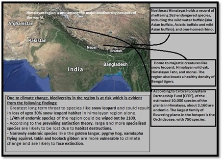
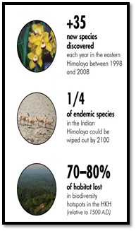
- Factors threatening Himalayan biodiversity
Himalaya mountain ecosystems are particularly fragile, subject to climate change and other anthropogenic drivers of change:
-
- Climate change: A report from India’s National Institute of Disaster Management cautioned that climate change is likely to
- Rising temperature and related glacial melt will aggravate the frequency of flash floods and Glacial lake outburst floods (GLOF).
- Change in weather patterns causing extreme weather events like high-intensity rainfall
- Increased frequency of climate change related natural disasters like landslides etc.
- Climate change: A report from India’s National Institute of Disaster Management cautioned that climate change is likely to
Example: A 2019 report by Kathmandu-based International Centre for Integrated Mountain Development said that 36% of the volume of glaciers in Hindu Kush Himalayan (HKH) region will be gone by the end of 2100 if the world manages to keep the temperature rise within 1.5 degrees Celsius as mandated by Paris Climate Agreement.
- Above factors are exacerbated by anthropogenic pressures, especially population pressure, deforestation and land-use changes that destabilize slopes and compound the adverse effects of climate change on biodiversity of the region.
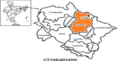
Case study: The glacial burst in the Chamoli district of Uttarakhand
Climate change and anthropogenic factor that destroyed ecological balance of the region-
- Climate change responsible for faster glacial melting causing glacial burst.
- Stone quarrying, blasting mountains and digging tunnels in the fragile mountain system for the under-construction dams on Rishi Ganga and Dhauli Ganga rivers caused two back-to-back floods in the region.
Above factors resulted in death of Himalayan ecology in the name of development.
- Above factors have following implications on biodiversity of Himalayan region: Mountain species are especially vulnerable, due to their limited ranges, geographic isolation, and specific adaptations
- Melting glaciers are expected to change moisture availability, which governs physiology, metabolic and reproductive processes, phenology, tree-line positions, and the geographic distribution.
- Changes in temperature will affect the growing season of wild and agricultural crops.
- Large-scale range shifts to higher altitudes, following favorable warm conditions, easier access of invasive species, from the expansion of hiabitat beyond their usual geographic ranges.
- Extinctions of certain species, particularly those that live near mountaintop: High elevation species that cannot adapt as well to changes in climate due to their limited geographic ranges, and are blocked from migrating by the climatic or geological barriers of the Himalayas. Example: snow leopards, brown bears, lesser pandas, and Tibetan yaks etc.
- Conservation efforts: Community-led strategies offer hope for conserving Himalayan biodiversity.
Example: The Singchung Bugun Village Community Reserve, an NGO in state of Arunachal Pradesh, won the National Biodiversity Discovery Award for its unique endeavour to conserve rare local wildlife on the fringes of the Eaglenest Wildlife Sanctuary.
- There are “Limits to Growth” and man must heed to such limits by following “Stop n Go determinism” (environmentalism) as most of the problems of ecological disruptions are related to extreme possibilism interpretations of Man-Environment relationship.
- Where can be used
- Geography
- P1- Climatology (climate change), biogeography and environ geo (biodiversity conservation, SD), Economic Geo (LTG), Regional development and planning.
- P2- Physical setting (physiographic division- India), Resources, Regional dev, contemporary issues.
- GS – P1 (Geophysical phenomena- CC), P3 (Environment-Conservation).
Links:
Rising Groundwater crises in India
- Why in news: A study in journal Science Advances on groundwater in India revealed that by 2025, large areas of country will have “critically low groundwater availability”, leading to a decrease in cropping, will ultimately cause an imbalance in the food security for millions.
- Background in brief: Groundwater resources have declined by 60% from 2009. According to Central Groundwater Board’s data, out of 718 districts 256 have reported critical or over exploited groundwater levels.
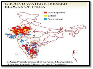
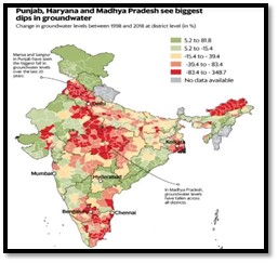
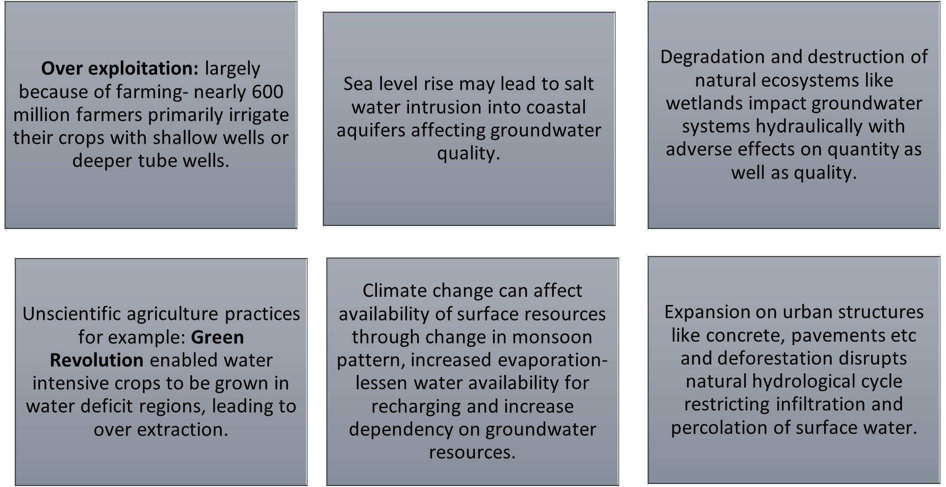
- What causes widespread depletion of groundwater resources in India?
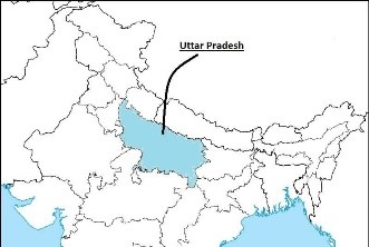
- Case study: Uttar Pradesh
UP has one of the world’s best developed aquifer systems, has had a tradition of dependency on groundwater despite high availability of surface water.
-
- As of March 2020, some 44 lakh tube wells catered to two thirds of state’s irrigation needs.
- Industrial demand and drinking water are also groundwater dependent, led to almost 70 per cent of the state’s 822 blocks and 80 per cent urban bodies witnessing a sharp decline in ground water levels and problem is compounded by a decline in rainfall that compromisesl recharge of aquifers.
- Implications of such crises:
- On agriculture and food security: GW shortage not only decline agriculture productivity but since 85% of drinking water supplies are dependent on it, shortage can have wide scale implications on drinking water supplies, with adverse impact on availability and assimilation component of food security. Example: Overuse of groundwater could cause winter harvests in some regions of the country to fall up to two thirds by 2025.
- Also farmers tends to sink deeper wells and are more likely to grow water-hardy crops and make investments in water-conserving irrigation technologies, which still decreases profits and lands them in debt. Example: Strong links between cash cropping, the failure of bore-wells, overwhelming debts and farmer suicides in the semi-arid regions of northern and western Andhra Pradesh and parts of the Deccan plateau.
- On economy: Water shortage can have significant impact on different industries as it can lead to production cuts or can lead to an existential crisis. Example: Thermal power plants, coal based power plants etc.
- On environment: The extreme use of groundwater resources can have serious concerns, such as uplifting and seismic activities, ecological environment deterioration, land subsidence, vegetation degradation, biodiversity loss and extinctions etc.
- Groundwater scarcity can also spur migration and conflicts.
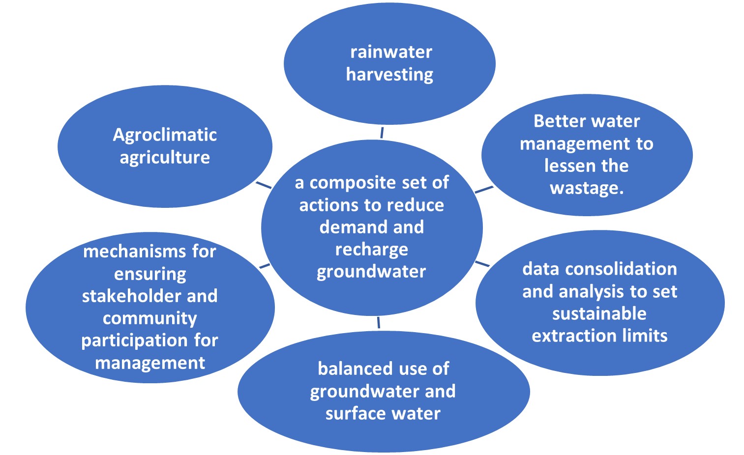
- With around one-sixth of assessed ground water units in the country facing ‘over-exploitation’, the Centre issued revised guidelines for groundwater use, prohibiting new industry and mining projects in ‘over-exploited’ zones and making it mandatory for existing industries, commercial units and big housing societies to take ‘no objection certificate’ (NOC) under ‘expanded compliance conditions’.
- Where can we use it
- Geography- P1- Climatology (climate change), Economic geo( agri, resources, LTG, sustainable dev), Regional dev and planning
- P2- Resources, agriculture, regional dev and planning- sustainable dev, contemporary issues.
- GS- P1 ( Distribution of key resources in Indian subcont),P2 (Issues relating to poverty and hunger), P3 (Agri, sustainable dev)
Links
- India’s Groundwater Is In Trouble. And It Could Cause a Food Shortage for Millions By 2025, Study Finds
- Behind India’s sugar dominance lies a hidden water crisis in Uttar
- Water Crisis: An Alarm For The Future
- Expert report points to 'inevitable’ groundwater crisis in UP
- Water-stressed in India: Reports from the districts
- India’s water crisis: The seen and unseen
- India's groundwater crisis threatens food security for hundreds of millions, study says
- Groundwater Loss in India Threatens Millions of Farmers' Ability to Grow Food
- India has a groundwater problem
- India’s groundwater crisis, fueled by intense pumping, needs urgent management
- Helping India Overcome Its Water Woes
- Groundwater Scarcity, Pollution Set India on Perilous Course
Functional Urban Areas
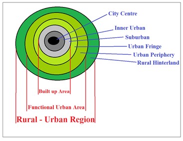
- According to Organisation for Economic Co-operation and Development (OECD), a Functional Urban Area (FUA) consists of a densely inhabited city and of a surrounding area (commuting zone) whose labour market is highly integrated with the city.
- The OECD and the European Commission (EU) have jointly developed a methodology to define FUAs in a consistent way across countries using population density and travel-to-work flows.
- Aim: The ultimate aim of the OECD-EU approach to FUAs is to create a harmonized definition of cities and their areas of influence for international comparisons as well as for policy analysis on topics related to urban development.
- Advantages of defining such area of influence: Urban decongestion, less traffic jams, less environmental pollution and reduced urban heat island effect.
- Classification: a) based on number of urban cores- Monocentric and Polycentric FUAs, b) based on population size- small urban areas, medium urban areas, metropolitan areas and large metropolitan areas.
- Examples: Greater Adelaide and Greater Hobart of Australia, Houston and Dallas of United States.
Source:
Sponge City
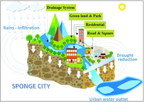
- A sponge city is an urban area that is designed to cope with excess rainfall and making a city more permeable using a variety of techniques. It’s a planning concept related to Urban Flood Management.
- Those techniques include: roof top green spaces, rain water harvesting systems, scenic wetlands for rainwater storage, permeable pavements that store excess water and allow evaporation for temperature moderation.
- Sponge cities absorb the rainwater, which is then naturally filtered by the soil and allowed to reach urban aquifers.
- Why they are necessary? Climate change coupled with haphazard urban growth led to increased intensity and frequency of urban floods which are highly devastating in nature.
- Benefits: Reduced urban flood risk, improved water quality, reduced water wastage, reduced urban heat island effect, ground water replenishment so that increased availability of water for various uses.
- Examples: Harbin and Lingang of China, Philadelphia of USA and Taipei of Taiwan.
Source:
Image Source:
Cirques
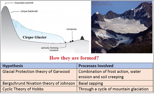
- These are armchair-shaped, amphitheater-like depressions that glaciers carve into mountains and valley sidewalls at high elevations. They are large-scale erosional features common to many mountainous regions.
- Variously named in different countries such as cwm in Wales, corrie in Scotland, kar in Germany, botn in Norway, etc.
- Why they are important: Because cirques are areas of snow accumulation, the direction in which they point can tell us something about the links between climate and glacier growth in the past.
- Components: Mainly 3 components. 1) Headwall, which is almost vertical with wall like steep slope. 2) Basin or floor of the cirque. 3) Threshold which is the outer margin of the cirque.
- Types: Mainly of four types. They are Simple Cirques, Compound Cirques, Hanging Cirques and Nivation Cirques.
Source:
- Page 482, Geomorphology Savindhra Singh.
- Cirques
Quail Farming: Koraput, Odisha
Background: Koraput, which is a part of the KBK (Kalahandi Balangir Koraput) region regarded as the most backward region by the Planning Commission. 82% of its families are below poverty line, very low HDI ranking & also the district is severely affected by Naxalism. Adding to these, the district and livelihoods of its inhabitants suffered a huge blow by the COVID-19 pandemic.
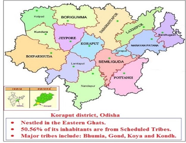

How Quail Farming has helped the tribes of Koraput to offset the effect of COVID-19 pandemic on livelihoods?
During the pandemic, in March 2021 Quail Farming has been introduced in Koraput by The Odisha Rural Development and Marketing Society (ORMAS) and MS Swami Nathan Foundation.
- They have procured Japanese quails from the Indian Council of Agricultural Research (ICAR), Bhubaneswar and provided those quails to women SHGs of Koraput to eke out a living during the pandemic.
- Around 2,000 women SHG members in Koraput have become successful quail farmers.
- Also, the fear of COVID-19 made many people to opt for eating quail meat to boost their immunity.
- As a result, quail farmers made good amount of money and it generated employment, supported livelihoods of tribal poor during the economic distress caused by the Pandemic.
This can also be replicated in other areas of India (mainly tribal belts of Chhattisgarh, Jharkhand and Madhya Pradesh) as quail farming offers a great scope and potential because of its supplementary income & additional employment to farmers and helps in achieving government’s target of doubling the farmers’ income by 2022. Also it could play a vital role in meeting the demand of food and nutrition.
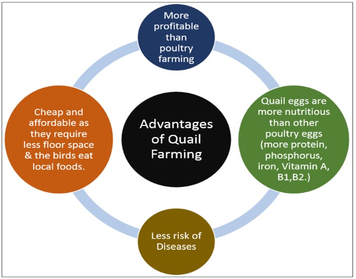
Where this case study can be used?
This case study can be used in topics related to: Paper 1(Food and Nutrition problems, Regional development strategies), Paper 2 (Poultry, Tribal area development).
Source:
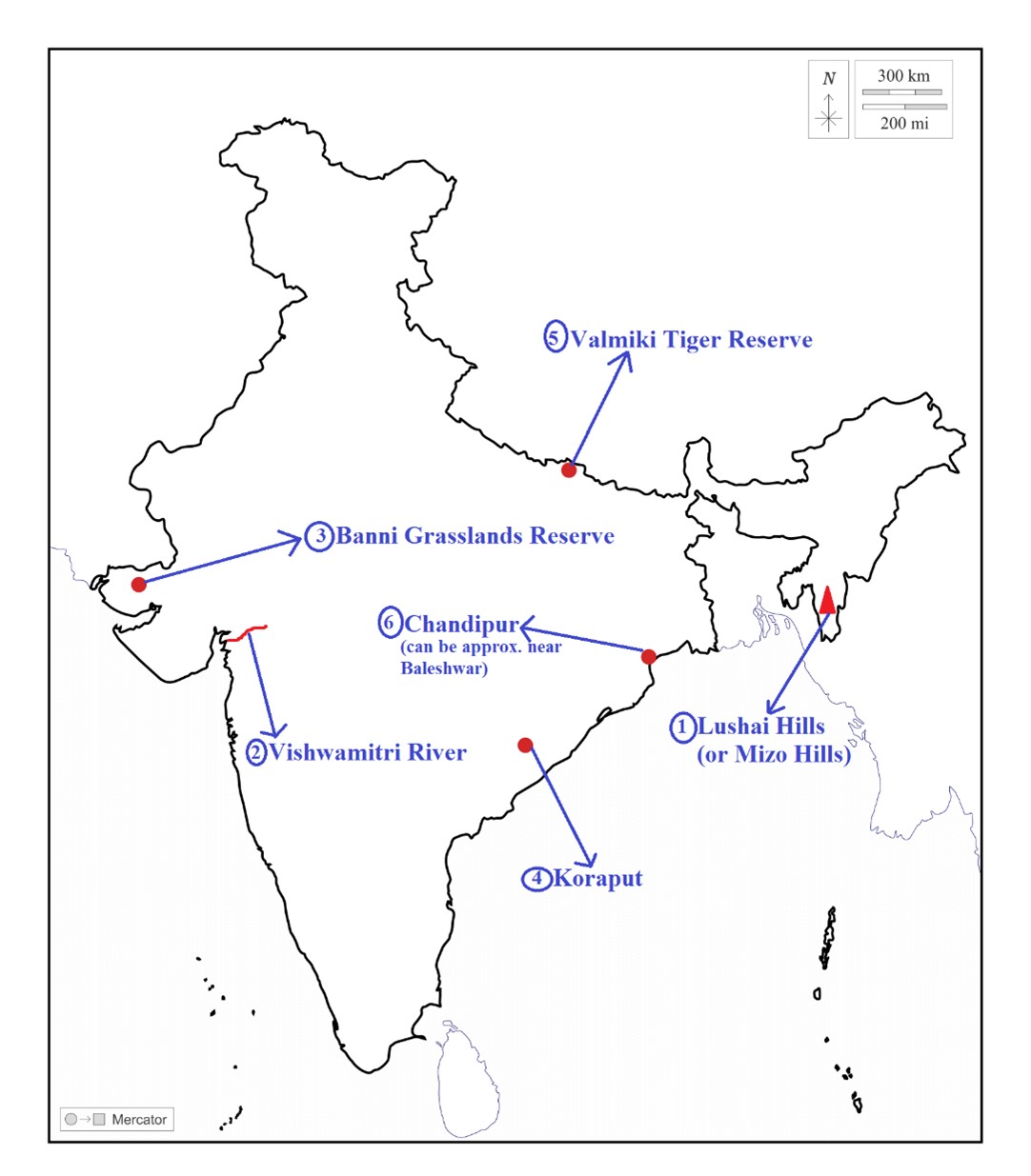
Map Source:
Lushai Hills
|
Lushai Hills:
|
|
Vishwamitri River:
|
|
Banni Grasslands Reserve:
|
|
Koraput:
|
|
Valmiki Tiger Reserve:
|
|
Chandipur:
|
Share the article
Get Latest Updates on Offers, Event dates, and free Mentorship sessions.

Get in touch with our Expert Academic Counsellors 👋
FAQs
Geography Current Affairs focuses on the contemporary issues, events, and developments in the field of geography. It covers recent geographical phenomena, environmental changes, geopolitical shifts, and related news. This differs from regular geography studies which may focus more on foundational concepts, historical contexts, and theoretical frameworks.
Updates are provided regularly to ensure that subscribers stay informed about the latest developments in geography. Typically, updates are provided on a fortnightly basis, depending on the frequency of significant events and changes in the field.
Absolutely. Geography Current Affairs serves as a valuable resource not only for Geography optional but also for GS papers, especially GS Paper 1 (covering Indian Heritage and Culture, History, and Geography of the World and Society) and GS Paper 3 (covering Technology, Economic Development, Biodiversity, Environment, Security, and Disaster Management). It aids in building a holistic understanding of various topics and strengthens answer-writing skills by incorporating contemporary examples and perspectives.
Geography Current Affairs holds immense importance for UPSC preparation, particularly for aspirants opting for Geography optional. It helps candidates stay updated with the latest developments, geographical phenomena, environmental issues, and geopolitical shifts worldwide, aligning them with the dynamic nature of the subject as tested in the UPSC examinations.

