
24 Mar to 10 Apr, 2025
MONSOON : FEATURES , THEORIES AND MECHANISM
Why in news : A study by the Indian Institute of Science (IISc) highlights that the strength of a monsoon cloud band plays a crucial role in determining its movement and the intensity of rainfall over the Indian subcontinent.
About :
Monsoon are seasonal reversal of winds with the change in season.
Origin of Monsoon
- Thermal Concept
- Dynamic Concept
Thermal Concept by Halley
Monsoon is result of
- Heterogeneous character of globe ( Unequal distribution of land and water )
- Differential seasonal heating and cooling of continents and oceans .
- SW monsoon : Sun shines over Tropic of Cancer . Brings low pressure in Indian subcontinent due to high temperature
.jpeg")
Dynamic Concept by Flohn
- Monsoon originated due to shifting of pressure and wind belts
- ITCZ formed due to convergence of NE and SE trade winds near equator
- Northern and Southern branches of ITCZ , known as NITCZ and SITCZ , create a belt of doldrums marked by equatorial westerlies .
- SW monsoon
- NE monsoon ( Winter or Retreating Monsoon )
.png")
Role of Jet Streams
Sub Tropical Jet Stream
- Sub-Tropical Jet stream is a narrow band of fast moving air flowing from west to east [Westerlies].
- STJ in northern hemisphere flows between 25° to 35° N in the upper troposphere at a height of about 12-14 km.
- The wind speeds in a westerly jet stream are commonly 150 to 300 km p.h. with extreme values reaching 400 km p.h.
STJ in Winters
- Westerly jet stream blows at a very high speed during winter over the sub-tropical zone.
- This jet stream is bifurcated by the Himalayan ranges and Tibetan Plateau.
- The two branches reunite off the east coast of China.
- The northern branch of this jet stream blows along the northern edge of the Tibetan Plateau.
- The southern branch blows to the south of the Himalayan ranges along 25° north latitude.
- A strong latitudinal thermal gradient (differences in temperature), along with other factors, is responsible for the development of southerly jet.
STJ in Summers
- As summer begins in March, the subtropical jet stream (STJ) starts moving northward. Its southern branch weakens but remains south of Tibet, while northern India experiences hot, dry conditions with strong solar radiation and hot winds like loo.
- The Intertropical Convergence Zone (ITCZ) shifts north as the STJ weakens, but monsoon rains only arrive after upper-air circulation transitions to its summer pattern. By late May, the southern jet breaks and shifts north of the Tibetan Plateau, triggering a sudden monsoon burst.
An easterly jet forms over peninsular India, reversing upper-air circulation:
- Upper layers: Convergence → Divergence
- Lower layers: High pressure → Low pressure
This shift strengthens the southwest monsoon, with active easterlies in the upper troposphere and westerlies (monsoon winds) below. The eastern jet intensifies near 15°N, enhancing rainfall.
Factors that Influence Monsoons
1. Mascarene High – The Reliable Anchor : This high-pressure zone in the southern Indian Ocean fuels monsoon winds. A strong Mascarene High means a robust monsoon, while delays in its formation can postpone rains.
.jpeg")
2. Coriolis Force – The Direction Setter : Earth’s rotation deflects winds eastward, splitting them into the Arabian Sea and Bay of Bengal branches, ensuring they reach India.
3. Indian Summer – The Heat Magnet : Intense pre-monsoon heating over north India creates low pressure, pulling in moisture-laden winds from the seas.
4. ENSO – The Unpredictable Foe : El Niño often weakens monsoon rains, causing droughts, but not always—some El Niño years still see normal rainfall.
.png")
5. Indian Ocean Dipole – The New Ally : A positive IOD (cooler east, warmer west Indian Ocean) boosts monsoon rains, while a negative phase suppresses them.
.png")
Role of Arctic Sea in Indian Monsoon
Reduced Sea ice in Central Arctic leads to two contrasting effects on India’s Monsoon
- Less rainfall in Western and Peninsular India : A decrease in Arctic sea ice leads to lower rainfall in this region. The reduction in ice alters atmospheric conditions, diminishing the transport of moisture from the sea and causing drier weather patterns in these areas."
- Increased Rainfall in Central and Northern India : The same atmospheric shifts due to the loss of Arctic ice increase rainfall in central and northern parts of the country. Changes in atmospheric circulation patterns can shift monsoon winds, increasing precipitation in this region.
Boreal Summer Intraseasonal Oscillation
- The BSISO is a monsoon pattern that moves convection (heat and cloud activity) from the Indian Ocean to the western Pacific during June - September.
- It controls monsoon’s ‘active’ (rainy) and ‘break’ (dry) phases influencing rainfall, wind patterns, and ocean waves.
- Accurate BSISO predictions help in coastal management and climate forecasting. Its strength and movement are modulated by El Nino Southern Oscillation (ENSO), with La Niña enhancing northward propagation and El Niño weakening it.
Source : https://www.downtoearth.org.in/environment/the-great-indian-monsoon-and-its-friends-49503
Where to use :
Paper I ( Geography Optional ) : Climate and Monsoons
Paper I ( General Studies ) : Mechanism of Monsoons
MYANMAR THAILAND EARTHQUAKE
Why in news : A massive 7.7 magnitude earthquake struck central Myanmar, causing widespread destruction, particularly in the city of Mandalay. This seismic event is one of the most powerful earthquakes in recent years.
About :
What Causes Myanmar Earthquake ?
- The Myanmar earthquake resulted from strike-slip faulting along the Sagaing Fault, a major tectonic boundary. This fault stretches 1,500 km through Myanmar, separating the Indian Plate (to the west) from the Eurasian Plate (to the east). It is one of the longest and most active strike-slip faults in the world.
- The quake was driven by the northward movement of the Indian Plate against the Eurasian Plate. Over time, stress builds up along the fault due to this plate interaction. When the accumulated strain is suddenly released, it generates seismic activity, leading to an earthquake.
- The earthquake’s epicentres was located 17.2 km from Mandalay, Myanmar’s second-largest city, at a depth of just 10 km.
Why are Shallow Earthquakes more destructive?
- Proximity to the Surface: Shallow earthquakes (less than 70 km deep) cause intense shaking. For example, the Myanmar earthquake occurred at 10 km, leading to rapid, forceful seismic waves and extensive damage.
- Energy Release: Shallow earthquakes retain more energy in seismic waves, causing stronger surface shaking and greater destruction.
- Higher Intensity: Shallow quakes produce higher intensity shaking, resulting in more structural damage compared to deeper quakes, where seismic waves lose energy.
- Aftershocks: Shallow earthquakes often lead to more intense aftershocks, further damaging already weakened structures. The Myanmar earthquake had aftershocks, including one with magnitude 6.4.
.png")
What is the Sagaing Fault?
- The Sagaing Fault is a major active tectonic boundary running north to south through Myanmar, separating the Indian and Eurasian Plates.
- It is one of the longest and most active strike-slip faults globally, extending 1,500 km from the Andaman Sea in the south to the Eastern Himalayas in the north.
- The Indian Plate is moving northward, causing stress buildup along the fault, leading to large earthquakes over time.
Types of Faults and Their Role in Earthquakes
- Faults are fractures in the Earth’s crust where rocks move due to tectonic stress. When stress accumulates beyond a critical limit, energy is released as seismic waves, causing earthquakes.
- The main types of faults include:
- Normal Fault: The hanging wall moves downward relative to the footwall, common at divergent boundaries. (Example: East African Rift Valley, Basin and Range Province in the U.S.)
- Reverse Fault: The hanging wall moves upward due to compression forces, occurring at convergent boundaries. (Example: Himalayas, Rocky Mountains)
- Strike-Slip Fault: The horizontal movement of fault blocks occurs with minimal vertical displacement, typical of transform boundaries. (Example: Anatolian Fault in Turkey, Sagaing Fault in Myanmar)
- Transform Fault: A specific type of strike-slip fault where tectonic plates slide past each other. (Example: San Andreas Fault in California)
Where to use :
Paper I ( Geography Optional ) : Geomorphology and tectonics
Paper I ( General Studies ) : Interiors of Earthquake and Faults
COTTON PRODUCTION IN INDIA
Why in news : India, once the world’s largest cotton producer and exporter, is facing a significant decline in cotton production, primarily due to the lack of technological advancements and policy inaction.
About :
India is the world's second-biggest textile exporter, trailing only China. Since cotton textile production is market-oriented, it depends on raw materials that have a long shelf life and do not spoil easily.
Factors Influencing the Location of the Cotton Textile Industry
- Raw Material – Being agro-based, a steady cotton supply is crucial. Initially, mills were near cotton-growing regions (e.g., Maharashtra, Gujarat), but improved transport has allowed expansion to other areas.
- Labour – A labour-intensive sector, it thrives on cheap workforce. India’s lower labour costs (compared to China) give it a competitive edge, employing over 45 million people directly.
- Climate – Cotton grows best in black soil with hot, humid conditions (e.g., Gujarat, Punjab). Spinning requires high humidity to prevent yarn breakage—why Mumbai (humid) became an early hub.
- Water Availability – Essential for dyeing, bleaching, and processing. Tiruppur (Tamil Nadu) grew as a textile hub due to abundant water, though overuse has led to sustainability concerns.
- Power Supply – Continuous, affordable electricity is vital. Surat’s textile boom is supported by Gujarat’s reliable power infrastructure. Earlier, mills clustered near coal belts (e.g., Kolkata).
- Market Access – Proximity to domestic and export markets drives location. Ludhiana (wool/cotton) serves North India, while Coimbatore supplies Southern markets.
- Transport & Ports – Efficient logistics reduce costs. India’s western ports (Mumbai, Kandla) handle textiles better than eastern ones (shallow waters). Export delays occur as goods are first shipped to deeper ports like Colombo before reaching Europe/America.
.png")
Key Concerns Over India’s Declining Cotton Production
- Growing Import Dependency
- Cotton imports doubled (USD 518.4M in 2023-24 → USD 1.04B in 2024-25), while exports dropped (USD 729.4M → USD 660.5M).
- Shift from net exporter to importer, weakening India’s global competitiveness (e.g., losing market share to the US and Brazil).
- Policy Paralysis on GM Cotton
- Indigenous GM innovations (e.g., NBRI’s pest-resistant varieties) face delays, while GM soyameal imports were allowed (2021).
- Moratorium on field trials and unclear regulations stifle R&D, pushing farmers to rely on outdated Bt cotton seeds (e.g., rising pest resistance in Punjab).
- Global Market Losses
- US and Brazil, with advanced biotech adoption, now dominate exports—India’s textile mills increasingly source costlier imported cotton (e.g., Surat’s rising input costs).
- Impact on Edible Oil Supply
- Cottonseed, India’s third-largest vegetable oil source, is shrinking—forcing higher edible oil imports (e.g., palm oil from Indonesia).
Initiatives in the cotton sector:
- PM Mega Integrated Textile Region and Apparel (PM MITRA) Parks Scheme
- Production Linked Incentive (PLI) Scheme to promote the production of MMF Apparel, MMF Fabrics and Products of Technical Textiles
- Cotton development programme under the National Food Security Mission (NFSM)
- Mobile app Cott-Ally to increase awareness about Minimum Support Price for Cotton
- Branding of Indian Cotton as “Kasturi Cotton India”
- Project “Targeting technologies to agro-ecological zones-large scale demonstrations of best practices to enhance cotton productivity” under NFSM
- SAMARTH (Scheme for Capacity Building in the Textile Sector)
- Amended Technology Upgradation Fund Scheme (ATUFS)
- Operationalize the five-year Mission for Cotton Productivity (announced in Budget 2025–26) to enhance yield, ensure sustainability, and promote Extra-Long Staple cotton cultivation (known for their superior quality, softness, and durability), thereby reducing import dependence.
Parliamentary committee’s Recommendations in 2024:
The government should implement an umbrella policy approach for the cotton sector, integrating activities across all areas. This would involve overhauling the cropping system, strengthening market linkages, enhancing research and development for new cotton varieties, and improving pest management practices. Additionally, the Government should focus on expanding irrigation to increase cotton cultivation productivity and address issues farmers face in obtaining genetically modified seeds, possibly through price caps and government-led seed development initiatives.
Source :
Where to use :
Paper II ( Geography Optional ) : Locational factors of Industries .
Paper I ( General Studies ) : Industries
Technical textiles - 10 April 2025
Technical Textiles: Technical textiles are defined as textile materials and products used primarily for their technical performance and functional properties rather than their aesthetic or decorative characteristics. Other terms used for defining technical textiles include industrial textiles, functional textiles, performance textiles,engineering textiles, invisible textiles, and hi-tech textiles. They are designed to have high levels of physical, mechanical, thermal, and/or chemical properties for use in specific applications within industrial sectors such as earthworks, construction, civil engineering, transport, defense, medical, and healthcare.
Light Fishing
Light Fishing: Light fishing involves the use of high-intensity artificial lights to attract fish and squid to the surface, making them easy to catch. Light fishing is prohibited under the National Policy on Marine Fisheries (NPMF), 2017 which aims to protect marine resources and promote sustainability by banning destructive practices like light fishing. Light fishing leads to the indiscriminate capture of fish, including juveniles, depleting stocks and threatening future populations.
Boreal Summer Intraseasonal Oscillation (BSISO)
Boreal Summer Intraseasonal Oscillation (BSISO) : BSISO is a movement of convection (heat) from the Indian Ocean to the western Pacific Ocean roughly every 10-50 days during the monsoon (June-September). The BSISO of the Asian summer monsoon (ASM) is one of the most prominent sources of short-term climate variability in the global monsoon system.
Bambi Bucket - 10 April 2025
Bambi Bucket : The Bambi Bucket, also called a helicopter bucket or a helibucket, is a specialised container that is suspended by cable under a chopper, and which can be filled by lowering into a river or pond before being flown above a fire and discharged aerially by opening a valve at the bottom of the bucket. The Bambi Bucket is especially helpful in fighting wildfires that are difficult or impossible to reach from the ground. Around the world, helicopters are frequently commissioned to fight forest fires.
Adolescent Birth Rate - 10 April 2025
Adolescent Birth Rate: The adolescent birth rate (ABR) is the number of births per 1,000 women aged 10–14 or 15–19, calculated annually. It is a demographic and socio-economic statistic that measures the risk of childbearing among females in that age group. The ABR is also known as the age-specific fertility rate.
MYANMAR BANGLADESH EARTHQUAKE 2025
South Asia, including Myanmar, is highly prone to earthquakes due to its proximity to the complex assemblage of some of the largest tectonic features on earth, including the Himalayas, the Shillong Plateau, the Southern Indo-Burman Range, and the Andaman-Nicobar subduction zone. Originating from the collision of the Indian and the Eurasian Plates some 40 million years ago.Myanmar is reeling following the huge earthquake which hit the country recently.
The 7.7 magnitude tremor was felt elsewhere, including in Thailand and south-west China.
More than 3,000 people have died and more than 4,500 have been injured.
.png")
https://www.rescue.org/article/myanmar-earthquake-whats-happening-and-how-help
Where to use : Earthquakes and Tectonic Activity
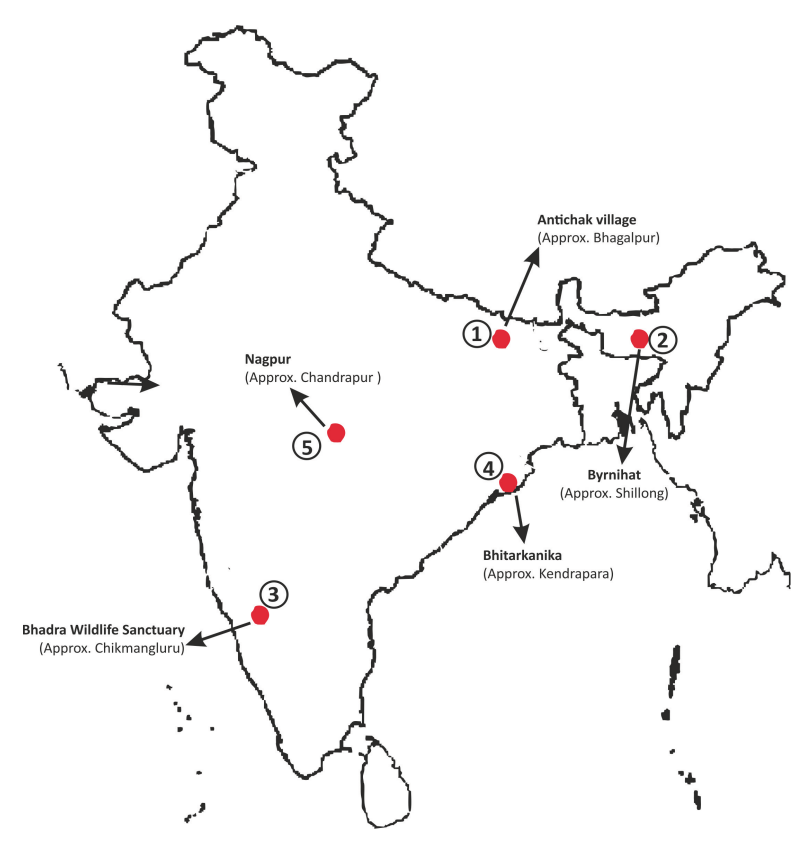
Places in News - 10 April 2025
1. Antichak village
Why in news : Ten years after the establishment of Nalanda University in Rajgir, efforts are underway to revive Vikramshila, another ancient centre of learning in Bihar, with land allocated for a Central University at Antichak village in Bhagalpur district.
- Antichak is a Village in Colgong Block in Bhagalpur District of Bihar State, India.
- It belongs to Bhagalpur Division . It is located 36 KM towards East from District head quarters Bhagalpur.
- This Place is in the border of the Bhagalpur District and Godda District. Godda District Mehrma is South towards this place .
- Approx: Bhagalpur
2. Byrnihat
Why in news : After years of opposition from Khasi pressure groups, citing concerns that rail connectivity may lead to a significant influx of outsiders in Meghalaya, Indian Railways has decided to abandon the pending railway projects for Byrnihat and Shillong.
- It is situated on the Assam-Meghalaya border, near Guwahati and Shillong.
- has developed into a regional industrial hub with industries involved in coke (fuel), cement, ferro alloys, steel, distillation, and brickmaking
- Approx : Shillong
3. Bhadra Wildlife Sanctuary
Why in news : Karnataka has proposed a “soft-release” strategy to manage the escalating human-elephant conflict in Hassan, Chikkamagaluru, and Kodagu districts by gradually rehabilitating captured elephants into the Bhadra Wildlife Sanctuary (BWS).
- It is located in the midst of the Western Ghats region of Karnataka.
- It is surrounded by hill ranges of Mullaianagiri, Hebbegiri, Gangegiri, and Babaudangiri.
- It is the first official tiger reserve to finish a successful village relocation programme and a success story in wildlife conservation.
- The Bhadra Sanctuary was declared India’s 25th Project Tiger in 1998 and listed its name in the list of national bird sanctuaries of Karnataka.
- It is also located near the Bhadra river and its tributaries such as Somavahini, Thadabehalla, and Odirayanahalla.
- Approx : Chikmangluru
4. Bhitarkanika
Why in news: The saltwater crocodile population in Bhitarkanika has significantly increased from 95 individuals in 1975 to 1,811.
- It is located at the confluence of rivers Brahmani, Baitarani, and Dhamra.
- It has a Crocodile Breeding Center at Dangmal.
- The place has second-largest mangrove ecosystem in India (after Sundarbans)
- Approx : Kendrapara
5. Nagpur
Why in news : The public outrage in Nagpur, leading to demands for the demolition of Mughal ruler Aurangzeb’s 17th-century tomb in Khuldabad, Chhatrapati Sambhaji Nagar has raised the discussion about Aurangzeb and Marathas.
- It is the winter capital and third-largest city of the Indian state of Maharashtra.
- It is called the heart of India because of its central geographical location.
- It is the largest and most populated city in central India. It is also known as the "Orange City"
- Approx : Chandrapur
Fortnightly KOSMOS MCQs Practice - 10th April 2025
Q1. Planetary Parade, a rare celestial event where seven planets align on one side of the sun, occurs due to?
- Planets orbit the Sun along a flat, disc-shaped path called the ecliptic plane.
- Gravitational forces between planets periodically pull them into alignment.
- The Sun’s magnetic field causes planets to temporarily shift their orbits.
- The alignment is a result of random movement of asteroids in space.
Q2. Which of the following releases the State of Global Climate Report?
- United Nations Environment Programme (UNEP)
- World Health Organization (WHO)
- World Meteorological Organization (WMO)
- Intergovernmental Panel on Climate Change (IPCC)
Q3. With reference to Betta Vulture Sanctuary, consider the following statements:
1. It was established in 2012 as India’s first and only vulture sanctuary to protect endangered vulture species.
2. It is the only sanctuary in India that harbors all nine vulture species found in the country.
Which of the statements given above is/are correct?
- 1 Only
- 2 Only
- Both 1 and 2
- Neither 1 nor 2
Q4. Which of the following best describes the term natural farming?
- A farming method that uses chemical fertilizers and pesticides for higher crop yields.
- A farming technique that involves monocropping and high water usage for crops.
- A farming practice that integrates genetically modified organisms (GMOs) to increase productivity.
- A chemical-free, traditional farming method that integrates crops, trees, and livestock with functional biodiversity.
Q5. Consider the following statements regarding ecosystem functions:
1. Energy flow in an ecosystem follows a unidirectional path, whereas nutrient cycling occurs continuously.
2. In a food chain, 90% of the energy is passed to the next trophic level, while 10% is lost at each level.
Which of the statements given above is/are not correct?
- 1 only
- 2 only
- Both 1 and 2
- Neither 1 nor 2
Q6. Consider the following milestones:
1. The Convention on Biological Diversity
2. The Statement on Forest Principles
3. Agenda 21
How many of the above was/were part of Earth Summit 1992?
- Only one
- Only two
- All three
- None
Q7. Consider the following species:
1. Hangul
2. Brow-Antlered Deer
3. Arabian Sea Humpback Whale
4. Malabar Civet
How many of the above is/are mentioned in Critically Endangered Category of IUCN Red list?
- Only one
- Only two
- Only three
- All four
Q8. Consider the following statements:
1. It is also known as Muthodi Wildlife Sanctuary.
2. It is a Project Tiger reserve, and hosts diverse forests, including Southern Moist Mixed Deciduous Forests, Dry Deciduous Forests, and Shola Forests.
3. It hosts diverse fauna, including tigers, leopards, dholes, gaurs, deer, and elephants.
Which of the following best matches the above description?
- Bandipur National Park
- Bhadra Wildlife Sanctuary
- Nagarhole National Park
- Dachigam National Park
Q9. Plumbism and Saturism, sometimes in news, is related to which of the following?
- A rare genetic disorder affecting blood clotting
- A nutritional deficiency affecting bone growth
- Lead poisoning caused by prolonged exposure to lead
- A new technique in water purification
Q10. Consider the following statements regarding fault :
1. It is a fracture or zone of fractures in the Earth's crust between two blocks of rock, allowing them to move relative to each other.
2. Earth scientists classify faults based on their dip and the direction of the movement along the fault.
3. Tectonic stress builds up along fault lines and, when released, causes the blocks to shift, leading to seismic activity.
How many of the statements given above is/are correct?
- Only One
- Only Two
- All Three
- None
Share the article
Edukemy’s Current Affairs Quiz is published with multiple choice questions for UPSC exams
MCQ
Get Latest Updates on Offers, Event dates, and free Mentorship sessions.

Get in touch with our Expert Academic Counsellors 👋
FAQs
Geography Current Affairs focuses on the contemporary issues, events, and developments in the field of geography. It covers recent geographical phenomena, environmental changes, geopolitical shifts, and related news. This differs from regular geography studies which may focus more on foundational concepts, historical contexts, and theoretical frameworks.
Updates are provided regularly to ensure that subscribers stay informed about the latest developments in geography. Typically, updates are provided on a fortnightly basis, depending on the frequency of significant events and changes in the field.
Absolutely. Geography Current Affairs serves as a valuable resource not only for Geography optional but also for GS papers, especially GS Paper 1 (covering Indian Heritage and Culture, History, and Geography of the World and Society) and GS Paper 3 (covering Technology, Economic Development, Biodiversity, Environment, Security, and Disaster Management). It aids in building a holistic understanding of various topics and strengthens answer-writing skills by incorporating contemporary examples and perspectives.
Geography Current Affairs holds immense importance for UPSC preparation, particularly for aspirants opting for Geography optional. It helps candidates stay updated with the latest developments, geographical phenomena, environmental issues, and geopolitical shifts worldwide, aligning them with the dynamic nature of the subject as tested in the UPSC examinations.