27 Nov
Global "population ageing"- Implications & opportunities
- In news: The Minister of Social Justice and Empowerment launched the SAGE (Senior care Aging Growth Engine) initiative and SAGE portal for elderly persons.
- Background:
- Population ageing is the increase in median age in population because of declining fertility rates and rising life expectancy. It is part of a long-term development called the demographic transition, which leads from a regime of high mortality and high fertility to one with low mortality and low fertility.
- Population ageing is a universal phenomenon. Nearly every country in the world is experiencing growth in both the size and the proportion of older persons in the population.
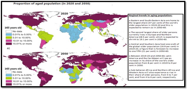
- Currently, there are an estimated 728 million persons aged 65 years or over in the world. In the next 30 years, this number is expected to increase to more than double its present value, reaching 1.5 billion older persons in 2050. The share of the global population aged 65 years or over is expected to increase from 9.3 per cent in 2020 to around 16.0 per cent in 2050.
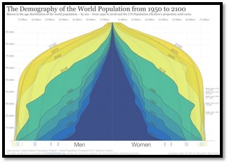
- The change from 1950 to today and the projections to 2100 show a world population that is becoming healthier. When the top of the pyramid becomes wider and looks less like a pyramid and instead becomes more box-shaped, the population lives through younger ages with very low risk of death and dies at an old age. The demographic structure of a healthy population at the final stage of the demographic transition is the box shape that we see for the entire world for 2100.
- Regional patterns of aged population in present and future:
- Implications of aging population:
- The Decline in the Working-Age Population: This leads to a supply shortage of qualified workers, making it more difficult for businesses to fill in-demand roles. An economy that cannot fill in-demand occupations faces adverse consequences, including declining productivity, higher labor costs, delayed business expansion, and reduced international competitiveness. In some instances, a supply shortage may push up wages, thereby causing wage inflation and creating a vicious cycle of price/wage spiral.
- Increasing Dependency Ratio: Countries with large elderly populations depend on smaller pools of workers where they collect taxes to pay for higher health costs, pension benefits, and other publicly funded programs. This is becoming more common in advanced economies where retirees live on fixed incomes with much smaller tax brackets than workers. The combination of lower tax revenue and higher spending commitments on health care, pension and other benefits is a major concern.
- Increased demand in Health Care: As life expectancies lengthen in the region, the demand for quality health care and long-term care increases. A large and growing ageing population requires more specialized health care and a greater pool of geriatric-trained medical personnel.
- COVID-19 is a pandemic with global health threats but elderlyare most vulnerable for severity and mortality: Aging comes with a myriad of psychological, social, and environmental vulnerabilities. Frailty in older adults brings in the risk of various infections and decrease in all forms of immune response. Also Pandemics have significant psychosocial impact- health anxiety, panic, adjustment disorders, depression, chronic stress, and insomnia are the major offshoots.

While the current generation of older people is experiencing higher incomes and lower poverty risks than previous ones in most countries, the younger generations are likely to face again higher inequality in old age. They are expected to live longer, but have been experiencing more unstable labor market conditions and widening inequalities in the distribution of earnings and household income.
- Opportunities:
- Ageing will create new opportunities for technology to respond to unmet needs of the elderly and improved health care- Countries where policy conditions enable innovation and entrepreneurship to thrive will be best placed to benefit from the “silver economy”.
Example: With a global shortage of caregivers, there is a growing role for eldercare technology – using digital tech, AI and robotics to provide routine help (lifting, carrying, feeding, washing), cognitive support and even social engagement.
- Ageing pushes society into making use of its underused human potential- As people live longer, older persons have accumulated expertise, knowledge and experience to an extent that was not possible in earlier times, and can therefore contribute a lot.
- Opportunities to enable individuals to participate more and longer in the labor market, dependency ratios could remain quite stable- productivity does not inevitably decline with age, while skills often shift with aging. Thus firms can take advantage of these changes and increase the application of production techniques that use age-appreciating skills more intensively.
- Population ageing offer opportunities for meeting a very diverse set of SDG targets:
Example:
- An ageing population would most likely increase policy demand for designing accessible and safe public spaces, which will have major implications for Target 11.7 (universal access to safe, inclusive and accessible, green and public spaces).
- Way forward:
- Broadening the scope of social protection to reduce poverty and income inequality of all, including for all older persons. Ensure that social protection systems cover an increasing proportion of the formal and informal working populations, paying attention to socially and economically disadvantaged groups, including older women.
- Reorient and prioritize healthcare to ensure that older persons have universal and equal access to quality health care without suffering the financial hardship associated with paying for care.

- Policy measures to address population ageing are critical for achieving the Sustainable Development Goals (SDGs), in particular for ending poverty in all its forms everywhere (SDG 1), ensuring healthy lives and promoting well-being for all at all ages (SDG 3), achieving gender equality and empowering all women and girls (SDG 5), promoting full and productive employment and decent work for all (SDG 8), and reducing inequalities within and among countries (SDG 10).
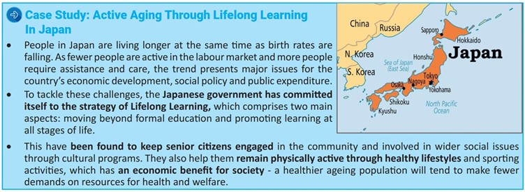
- The gender dimension of population ageing and the policy implications and challenges of a greater share of women amongst older populations had to be addressed in any national planning activity focusing on the needs of older persons. This could be done by applying dimensions of feminist geography in planning which incorporate positions of race, class, ability, and sexuality in its domain.
Ageing itself is part of the natural course of demographic development. Society has to adapt to that change, and it becomes a problem when timely action for adaptation is not taken. As the ageing process is predictable and gradual, it allows gradual adaptation that is usually much less costly than emergency actions taken as a last resort.
Where it can be used: Paper1 - Population geography (demographic attributes, Causes and consequences of migration) human development index, Paper2- Cultural setting (demographic attributes)
Tags: UPSC, Geography optional, population geography, demographic attributes, life expectancy.
Links:
- Ageing
- Ageing populations: the challenges ahead
- What UNECE does for you
- Which Country Has the Oldest Population? It Depends on How You Define ‘Old.’
- Ageing and demographic change
- Addressing the Challenges of Population Ageing in Asia and the Pacific
- Future of an Ageing Population
Frothing in Yamuna- Causes & solutions
In News
There have been repeated instances of Layers of froth floating over parts of the Yamuna in Delhi.
What causes frothing in the Yamuna?
- The froth is a sign of a polluted river. Experts say the release of untreated or poorly treated effluents could lead to frothing.
- Yamuna receives untreated sewage from Delhi, Haryana and Uttar Pradesh, and pollution from sugar and paper industries in Uttar Pradesh.
- Specifically, phosphates in the river form the froth. Surfactants and phosphates from detergents in households and industrial laundry find their way into the river. While these two components (phosphates and surfactants) comprise of 1 per cent, the remaining 99 per cent is air and water.
Reasons for foaming around this time of the year
- The river is in a lean phase and the water flow is less. Pollutants, therefore, are not diluted.
- Another reason, but not a major one, for the frothing is the release of certain gases when a specific kind of bacteria become active in anaerobic conditions - when there is no or little oxygen is available.
Location of Foam formation
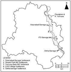
- The CPCB report submitted in August 2020 notes that foam formation takes place at two locations – downstream of the ITO and Okhla barrages. The turbulence at the barrage near Okhla due to falling water generates foam from the phosphates.
Unplanned Urbanization of Delhi aggravated pollution load in Yamuna
- The river with total length of 1370 kms has its most poisonous stretch between Wazirabad and Okhla accounting for only 2% of the total stretch but around 80% of the total pollution load in the river. This happens as the load of pollutants near Okhla gets highly loaded.
- Rapid growth of Delhi has resulted in the generation of huge quantities of untreated sewage and wastewater which discharge into the river.
- The vast floodplains, which serve as a floodway and help recharge ground water, have also been gradually eliminated to a great extent and encroached upon by gradual reclamation by dumping solid wastes and construction of various buildings. This has reduced the flood carrying capacity, groundwater recharging capacity, and other biodiversity related ecological functions.
- The morphology of the river and the wetland functions are also altered by embankments, bunds, roads, flyovers, guide bunds and spurs, several bridges and three barrages.
- Yamuna’s flow has been restricted at three locations in Delhi to sustain the water supply in order to meet the ever-growing demands of the city people: Wazirabad, ITO and Okhla barrages.
- Generally, a very small quantity of water is allowed to flow beyond Wazirabad barrage in dry season, as the available water is not adequate to fulfill the demand of water supply of Delhi. Whatever water flows in the downstream of Wazirabad barrage is the untreated or partially treated domestic and industrial wastewater contributed through several drains.
What are the health hazards?
- Short-term exposure can lead to skin irritation and allergies. If ingested, these chemicals may cause gastrointestinal problems and diseases like typhoid.
- Long term exposure to heavy metals in industrial pollutants can cause neurological issues and hormonal imbalances.
Biodiversity loss: Foaming due to pollution can result in algae blooms and harm aquatic life due to low dissolved oxygen from decomposition processes. In November 2020 Zero Dissolved oxygen at seven of nine ghats along Yamuna was recorded by Delhi Pollution Control Committee. This creates dead zone and biological deserts in the fresh water ecosystem.
Solution- Way Forward
An Expert Committee constituted by Ministry of Environment and Forests recommended the following action plan-
- Solid Wastes, Garbage Dumps and Encroachments: No construction and development work be allowed on floodplains. All solid waste dumps including those used for roads and bunds within the active floodplain should be removed forthwith.
- River Zoning of Yamuna: Rivers require a certain space to carry their peak flows and sediments, and for their ecological functions. This includes the river channels and the floodplains which together are often designated as river corridor or floodways or simply the river zone. The River Zone so designated should be preserved and protected for the conservation and restoration of the river. No development activity should be permitted within the river zone that encroaches upon the active floodplain, obstructs the flow or pollutes the river (solid waste or wastewater).
- The Yamuna Riverfront Development (YRFD) Scheme: This scheme should be replaced by a plan for restoration of the river and its floodplain.
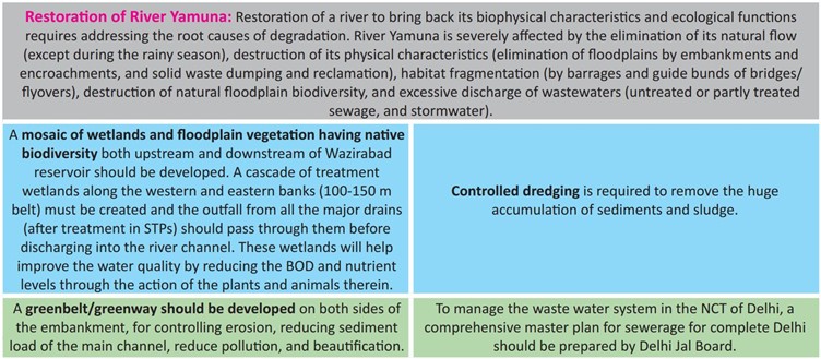
- Institutional Arrangements: The 52 km stretch of the river Yamuna in the NCT of Delhi and UP should be declared as a Conservation Zone under section 3 of the Environmental Protection Act 1986 and appropriate rules be framed for the human activities to be permitted or prohibited.
Stringent implementation of guidelines against dumping harmful waste into the river, and making sure untreated sewage does not enter the water are two things pollution control bodies are expected to do. However, neither Haryana nor Delhi have been able to ensure the same.
But, a more organic method agreed upon by environmentalists and experts is to maintain a sustainable minimum flow, called the ecological flow. This is the minimum amount of water that should flow throughout the river at all times to sustain underwater and estuarine ecosystems and human livelihoods, and for self-regulation. It is, however, a sore point between the two state governments.
It is time to think out of the box. For example, consider the following design: wastewater, as sewage, passes through a series of natural filter bunds in cascading fashion, designed to isolate physical contaminants. The churning water helps to biodegrade the organic matter before it is drained onto wetlands that have several select species of grasses and microorganisms that then transform the water from lifeless to ‘life-full’ before it enters the river

Where it can be used?
It can be used in topics related to Paper 1 (Environmental Degradation, Problems of Urbanization), Paper 2 (Water resources, Urbanization) and GS3 (Environmental Degradation).
Tags: UPSC, Geography, Optional, Yamuna Frothing, River pollution, Environmental Degradation.
Sources:
Climate Engineering- For addressing challenges of climate change
What is Climate Engineering?
• Climate Engineering or Geoengineering is the intentional large-scale manipulation and modification of the Earth’s climate and environment to prevent further Climate Change, slow down and reverse Global Warming, and mitigate their effects on our civilization and biosphere.
• The main goal of climate engineering or geoengineering is to bring global temperatures and carbon dioxide levels back to pre-industrial/pre-fossil fuel levels.
Several climate engineering solutions for addressing climate change:
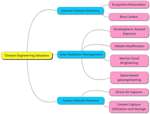
- Ecosystem Restoration: It is the act of repairing, rebuilding or restoring degraded or destroyed ecosystems and the ecological processes that support these systems, thereby removing carbon dioxide from the atmosphere and storing it (i.e., carbon sequestration) in the plants, animals and environment (e.g., organic matter in soils, etc.) of repaired or improved natural communities. The concepts of “ecological succession” and the “climax community” are central to the science of ecosystem restoration. Successful ecosystem restoration projects have designs that closely align with or match the true or natural climax of the area or fall within a stage of the natural successional trajectory.

- Blue Carbon: Blue Carbon Ecosystems are coastal, estuarine and marine photosynthetic ecosystems that have the capability to absorb significant amounts of carbon dioxide from the atmosphere or environment and store it for long periods of time. Blue Carbon Ecosystems include saltmarshes, sea grass meadows, mangrove forests, microalgae communities such as kelp forests, and freshwater tidal ecosystems such as coastal bald cypress floodplain forests
E.g. Sea grass meadows, mangrove forests and salt marshes, which cover approximately 0.5% of the area of the world’s oceans, account for more than 50% of all blue carbon and carbon sequestration in ocean sediments
- Stratospheric Aerosol Injection: This approach involves spraying of reflective sulfate aerosol particles into the stratosphere with high altitude airplanes, tethered balloons, high-altitude blimps or artillery to reflect sunlight into space in order to cool the planet and reverse or stop Global Warming.
- Albedo Modification: It includes several technologies designed to reflect a small fraction of incoming sunlight back to space in order to attenuate anthropogenic changes in temperature and other climate variables. Similar to this, ocean albedo modification is an approach that increases the reflectivity or albedo of the surface of the ocean using micro bubbles or sea foam.
- Marine Cloud Brightening: In this approach the reflectivity or albedo of marine clouds is increased by seeding them with seawater aerosol. This is a very promising solution to counteract Global Warming because it is easily implemented, potentially very effective and environmentally friendly.
- Space-based geoengineering: It consists of the deployment of objects in space that can block or reflect sunlight away from the planet. Approaches include sunshades, reflectors or mirrors, and clouds of sun blocking particles. Researchers have proposed that these objects should be placed in orbit around the planet or at the L1 Lagrange point.
- Direct Air Capture (DAC): The DAC process generally utilizes large fans that blow air across a filter that captures CO2 out of the air. Once the CO2 is separated from the filter it is compressed into a liquid and generally pumped underground into stable porous rock layers where it is stored for thousands of years.
- Carbon Capture Utilization and Storage (CCUS): It involves isolating CO2 from fossil fuel power stations in pre or post-combustion processes, compressing the CO2 until it forms a liquid, transporting the liquid CO2, often through pipelines, and then pumping it deep underground into porous rock layers that can safely hold it for long periods of time. g. Norway’s Longship project is a full scale CCUS programme with a capacity of up to 1.5 million tonnes of CO2 per year.
Potential challenges associated with the climate engineering solutions:

Way forward:
Climate engineering should be a supplement to emissions cuts, not a substitute for them. It is possible that a combination of emissions cuts and climate engineering could provide a significantly safer climate than emissions cuts alone.
Where it can be used?
It can be used in topics related to Paper 1 (Heat budget of the earth, Climate Change, Sustainable development), Paper 2 (Sustainable growth) and GS1 (Physical geography).
Tags: UPSC, Geography, Optional, Climate engineering, Geoengineering, Climate Change, Global warming.
Sources:
Green Highways
- Why in news: Green highway construction gathers speed due to India’s net zero commitments.
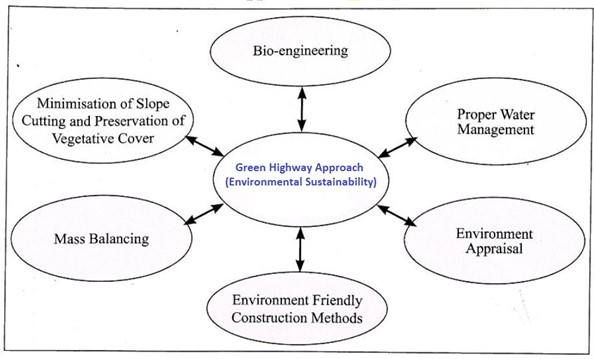
- A green highway is that highway constructed using materials that emit no or low concentration of pollutants and are environment-friendly. This concept integrates transportation functionality and ecology.
- Techniques used for greening of highways:

- MoRTH has launched Green Highways (Plantation, Transplantation, Beautification & Maintenance) Policy in 2015 with an aim to promote greening and development of eco-friendly National Highway corridors across the country with participation of the community, farmers, private sector, NGOs, and government institutions.
- Objective:To reduce the impact of air pollution and dust by planting trees and shrubs along the National Highways. They will act as natural sink for air pollutants, reduce sound pollution, moderate the effect of wind and incoming radiation, arrest soil erosion at the embankment slopes and prevent glare from the headlight of incoming vehicles.
- The policy will strike a balance between highways development and environmental protection. It will also help in providing employment to 5 lakh people of the rural areas.
Sources:
Nutrition Smart Village
- Nutrition Smart Village’ (NSV) concept is based on the multisector approach to primarily address the underlying causes of malnutrition and create awareness about the rights and entitlements of the community. The basic causes can be addressed by ‘building an enabling environment’. Sustainable reduction of long-term chronic malnutrition can be made possible by addressing the majorly the underlying and basic causes.
- NSV – a multisectoral approach in addressing malnutrition:
- The NSV concept demonstrates inter-linkages between agriculture, natural resource management, WASH, education and livelihoods with nutrition.
- It also focuses on the Right to Food and empowers the community towards accessing entitlements and reducing dependency on markets.
- Components of NSV initiative:
- Nutrition Camps: During the camps, undernourished children (6-36 months) are screened followed by sensitizing the mothers on infant feeding, hygiene and care practices.
- Nutrition gardens and Sustainable Integrated Farming System (SIFS): families are also trained on creating their own homestead nutrition gardens. This helps the family to grow and cook diverse food for the malnourished child.
- Linking Agriculture and Natural resources with Nutrition (LANN+).
- Nutrition Sensitive Microplanning.
- Strengthening Institutions: such as Self-Help Groups, farmers groups and committees mandated under the Government programs.
- Potential Benefits of NSV: promoting nutritional awareness and behavioral change in rural areas and harnessing traditional knowledge to overcome malnutrition and implementing nutrition-sensitive agriculture through homestead agriculture and Nutri-garden.
Tags: UPSC, Geography Optional, Food security, Nutrition smart village.
Links:
Catch the Rain Campaign
- Why in news: Ministry of Jal Shakti has launched the ‘Catch the Rain’ Awareness Generation Campaign under National Water Mission in 2020 with the tagline “Catch the rain, where it falls, when it falls”.
- Aims: To nudge the states and stake-holders to create appropriate Rain Water Harvesting Structures (RWHS) suitable to the climatic conditions and sub-soil strata before monsoon & to engage people at the grassroots level through effective campaigning and Information, Education and Communication (IEC) activities for implementation of the campaign.
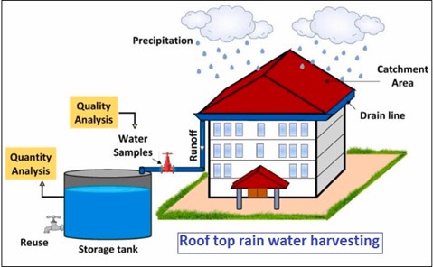
- Measures: Under this campaign, drives to make check dams, water harvesting pits, rooftop RWHS etc. removal of encroachments and de-silting of tanks to increase their storage capacity; removal of obstructions in the channels which bring water to them from the catchment areas etc.; repairs to step-wells and using defunct bore-wells and unused wells to put water back to aquifers etc. are to be taken up with the active participation of people.
- To facilitate these activities, states have been requested to open “Rain Centers” in each district. These centers act as technical guidance centers to all in the district as to how to catch the rain, as it falls, where it falls.
- Benefits: This will help in improving soil moisture and rising ground water table. In urban areas it will reduce water gushing onto roads, damaging them and will prevent urban flooding.
- Under this initiative, all water bodies in the districts are to be enumerated, (checked with revenue records) and encroachments to be removed.
Source:
Geothermal Power Development in Kenya’s Rift Valley
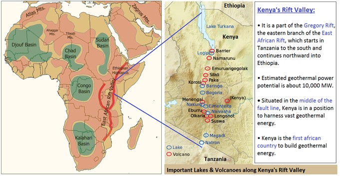
Important challenges faced by Kenya:
- Poverty: An estimated 15.9 million people were living in poverty in 2020, which equates to about a third of all Kenyans and access to electricity is still unavailable for a quarter of the population which is correlated with poverty. Rural areas have the highest concentration of multidimensional poverty.
- Energy challenge: Kenya’s electricity supply has long been heavily dependent on large hydropower, accounting for almost half of the countries installed capacity. It has become increasingly unreliable due to climate change induced water stress and changing rainfall patterns. Moreover, Kenya has not yet been able to meet its rapidly growing demand for energy.
Measures taken by Kenya for promoting geothermal energy as part of its energy profile:
- Kenya’s Vision 2030: It emphasized on institutional reforms in the energy sector, including a strong regulatory framework, encouraging more private generators of power, and separating generation from distribution. These reforms have provided a framework for independent energy production, including geothermal power.
- Project Implementation and Steam Supply Agreement (PISSA) model: Under this model, Government will take care of exploration and geothermal field development phase, while third parties are responsible for developing the power plants that use the steam. This model shifts exploration and resource risks away from private investors that purchase steam from government at the official feed-in-tariff.
- Financial and risk mitigation measures: Government addressed resource and explorations risks through DFI loans and grants & credit risks through partial risk guarantee schemes. In addition, the desired commercial rate of return was ultimately achieved by means of concessional loans.
- Multi sector and multi-stakeholder approach: It provided an optimum mix of knowledge, financing, and risk mitigation to support an expansion of geothermal installed capacity that one party alone would not be able to provide.
How geothermal power development has helped Kenya?

This can be replicated in India’s geothermal provinces such as SONATA lineament belt, Puga geothermal field and Sohna thermal region.
Where it can be used?
It can be used in topics related to Paper 1 (Energy Crisis, Climate Change), Paper 2 (Energy Crisis, Regional Development) and GS 3 (Energy).
Tags: UPSC, Geography, Case Study, Optional, Geothermal energy, Kenya, Rift Valley, Renewable energy, Energy security.
Sources:
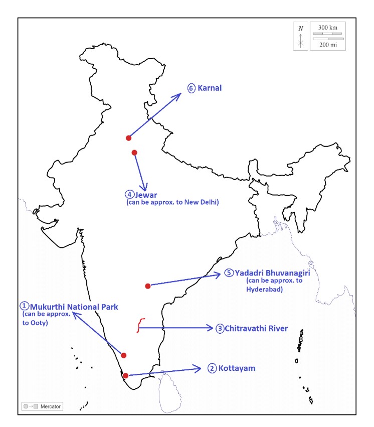
Mukurthi National Park
|
Mukurthi National Park · Why in news: The iconic Nilgiri tahr (Tamil Nadu’s state animal) population is trying to re-colonize habitats from which they were previously decimated due to poaching and habitat loss. · It is located in the western corner of the Nilgiris Plateau west of Ooty hill station in the northwest corner of Tamil Nadu. · The park is a part of Nilgiri Biosphere Reserve & as part of the Western Ghats, it is a UNESCO World Heritage Site. · Montane grasslands, Shrublands and Shola forests found here. · Important fauna here includes Royal Bengal tiger and Asian elephant. Nilgiri Tahr is the keystone species here. · Toda tribe found here. |
|
Kottayam · Why in news: Kottayam growing as a hub of experiential tourism as part of Responsible Tourism Mission. · It’s a district in Kerala flanked by the Western Ghats on the east and the Vembanad Lake on the west. · Major rivers in the district are the Meenachil River, the Muvathupuzha River and the Manimala River. · Climate: Tropical monsoon climate (Koppen, Am), Vegetation: tropical evergreen and moist deciduous forests. · Riverine alluvial and lateritic soils found here. · Kottayam economy largely depend on its thriving rubber industry and spice exports. |
|
Chitravathi River · Why in news: Due to heavy rainfall, swelling of Chitravathi, Papagni and Penna rivers caused severe floods in the Rayalaseema region of Andhra Pradesh. · It is an inter-state & seasonal river in southern India that is a tributary of the Pennar River. · The river originates at Chikkaballapur and flows through the Chikkaballapur district of Karnataka before entering Andhra Pradesh where it drains the districts of Anantapur and Cuddapah before joining the Pennar. · Rampant sand mining in its basin resulted in severe depletion of ground water resources in the region. · The pilgrim town of Puttaparthi is located on its banks. |
|
Jewar · Why in news: Prime Minister laid the foundation stone of the Noida International Airport in Jewar. · It’s a town located in Gautam Buddha Nagar District of Uttar Pradesh. · It is situated on the northeast bank of the Yamuna River. · Monsoon type of climate with dry winters (Koppen, Cwg) found here. · Tropical dry deciduous vegetation found here. · Riverine alluvial and loamy soils found here. |
|
Yadadri Bhuvanagiri · Why in news: Pochampally village of Yadadri Bhuvanagiri district awarded the Best World Tourism Village tag by UNWTO. · It’s a new district carved out of erstwhile Nalgonda district of Telangana. · Musi River (tributary of the Krishna) is the important water body in the district. · Tropical savannah type of climate (Koppen, Aw) found here. · Vegetation: Tropical dry deciduous, important species: teak, tendu and rosewood. · Agriculture is the main occupation of people here. Important crops: Paddy, jowar, bajra and grams. |
|
Karnal · Why in news: Kurak Jagir village of Karnal district has set a precedent in greywater management with its pond-based treatment systems. · It’s a district in Haryana & lies on the western bank of the river Yamuna. · The district is a part of the Indus-Ganges plain (Upper Yamuna Basin). · Its geographical area has been divided into three agroclimatic regions: Khadar, Bangar and Nardak belt. · Agriculture is the main occupation here. The district is termed as rice bowl of Haryana. · Vegetation: Tropical dry deciduous, important species: teak, tendu and rosewood. |
Share the article
Get Latest Updates on Offers, Event dates, and free Mentorship sessions.

Get in touch with our Expert Academic Counsellors 👋
FAQs
Geography Current Affairs focuses on the contemporary issues, events, and developments in the field of geography. It covers recent geographical phenomena, environmental changes, geopolitical shifts, and related news. This differs from regular geography studies which may focus more on foundational concepts, historical contexts, and theoretical frameworks.
Updates are provided regularly to ensure that subscribers stay informed about the latest developments in geography. Typically, updates are provided on a fortnightly basis, depending on the frequency of significant events and changes in the field.
Absolutely. Geography Current Affairs serves as a valuable resource not only for Geography optional but also for GS papers, especially GS Paper 1 (covering Indian Heritage and Culture, History, and Geography of the World and Society) and GS Paper 3 (covering Technology, Economic Development, Biodiversity, Environment, Security, and Disaster Management). It aids in building a holistic understanding of various topics and strengthens answer-writing skills by incorporating contemporary examples and perspectives.
Geography Current Affairs holds immense importance for UPSC preparation, particularly for aspirants opting for Geography optional. It helps candidates stay updated with the latest developments, geographical phenomena, environmental issues, and geopolitical shifts worldwide, aligning them with the dynamic nature of the subject as tested in the UPSC examinations.

