05 Mar
Russia - Ukraine Crisis viewed from the Lenses of Geopolitical Theories
In News
Russian invasion of Ukraine necessitated a revisit to the classical geopolitical theories.
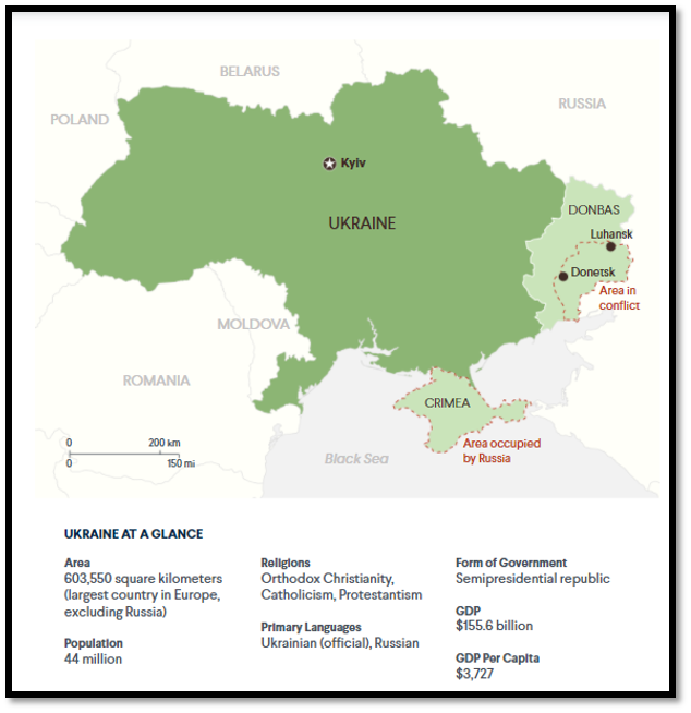
Geographical details of Ukraine
- Ukraine lies within Eastern Europe, and borders Russia to the east and northeast, Belarus to the northwest, Poland, Slovakia and Hungary to the west, Romania and Moldova to the southwest, and the Black Sea and Sea of Azov to the south and southeast, respectively.
- Ukraine has long been termed as “global breadbasket” because of its extensive, fertile farmlands; the country still remains one of the largest grain exporter world-wide.
- It includes a very large heavy industry sector, particularly in aerospace and industrial equipment.
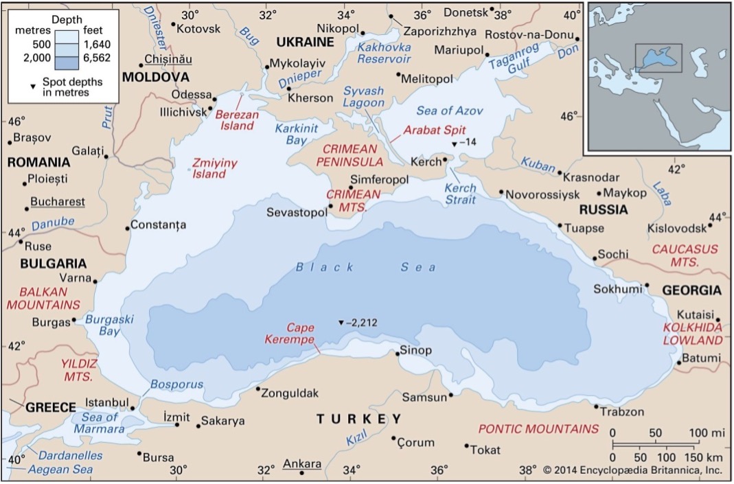
- In terms of geopolitics, apart from the extremely important port of Odessa, particularly discussion is necessary for the Crimean Peninsula and Sevastopol (Black Sea port on Crimea).
- Ukrainian territory plays a very important role in the transport of Russian energy resources such as gas towards the West via pipe-lines.
Classical Geopolitical Theories Explained
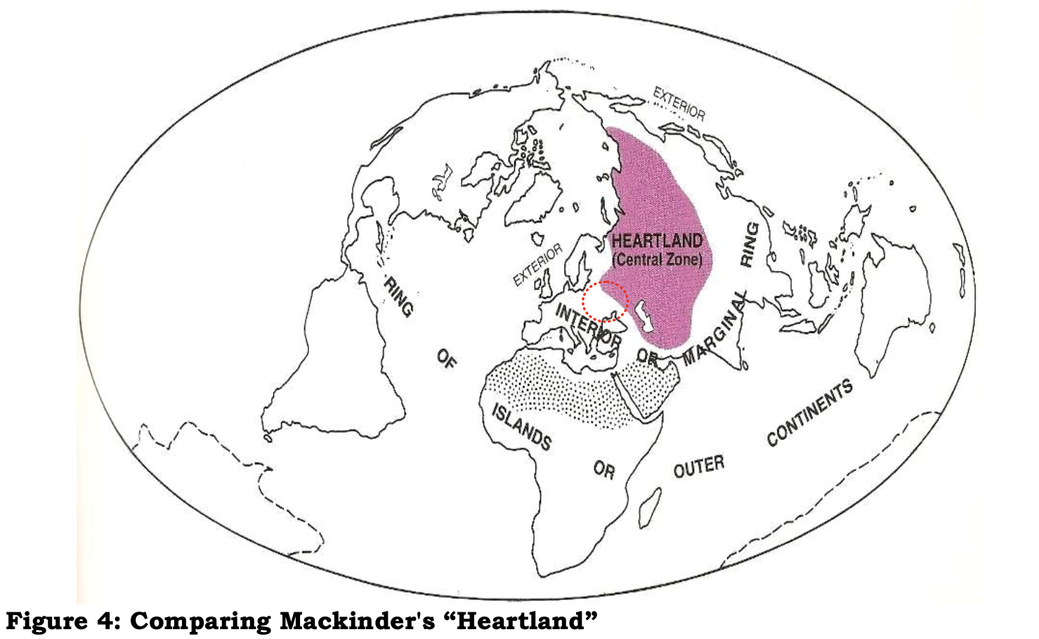
- Mackinder’s Heartland
-
- The British geographer Sir Halford Mackinder emphasized the control of “Heartland” as an interim step towards world dominance.
- The Heartland describes vast land masses of Eurasia, which are protected from the glaciers of the Arctic North.
- One of their most significant characteristic is that they have easy access to the sea and overlook canals and important straits (maritime traffic choke-points).
- Indeed, Mackinder's best-known saying is the following: “The one that governs Eastern Europe prevails over the Heartland. The one that governs the Heartland prevails over the Global Island. The one that governs the Global Island prevails upon the globe".
- Mahan’s Geopolitical Theory
- The American Alfred Thayer Mahan was influenced by the naval fleet led supremacy of Imperial Britain in the international system of the 16th-17th century era.
- Mahan put forward the idea that “the nation which will dominate the seas shall control the whole world”.
- According to his dogma, no country can be regarded as a global power if its navy is not potent and sufficient enough to promote its power and presence all over the world.
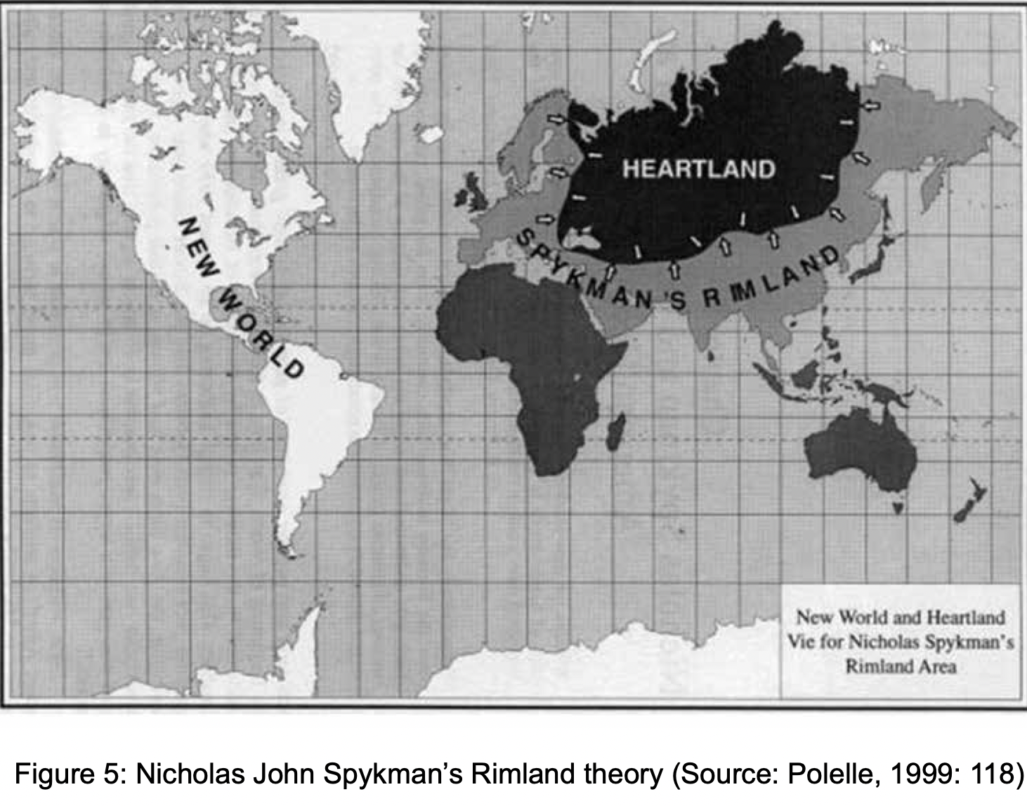
- Spykman’s Rimland
- Nicholas J. Spykman expanded upon Mackinder’s "Eurasia pivot theory" by positing the idea that control of the Eurasian Heartland positioned any power to take all or parts of the surrounding “Rimland" (Europe, the Middle East, India and China).
- Spykman gave his famous dictum based upon American geopolitical realities: “Who controls the rimlands controls Eurasia. Who controls Eurasia controls the world.”
- Control of both Heartland and Rimland positioned any power to go after what Mackinder called the “World-Island’’ of Eurasia and Africa.
Russian invasion of Ukraine and validity of Geopolitical Theories
- Most of the grand theories of classical geopolitics were sequestered at the end of the Cold War. They were overly totalising, generalising, and universal to explain modern phenomena. The new neoliberal world, with all its messy contradictions and complexities, was simply too vast and too unforeseeable to be predicted with grand theories.
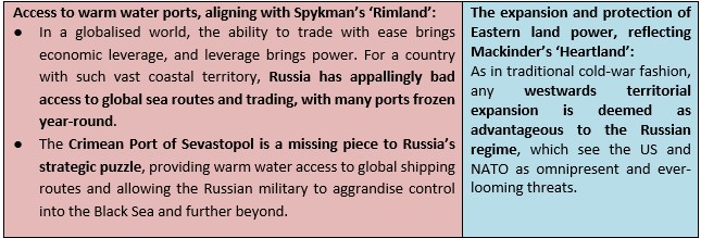
- But modern Russia has proven itself to be an exception, reviving the geopolitical theories of Halford Mackinder’s ‘Heartland’ and Nicholas Spykman’s ‘Rimland’ from the shadows. Amongst other enticements, Russia’s desire to irreversibly absorb Eastern Ukraine into its desired territory can be reduced to two main factors relating to these theories:
- Access to warm water ports, aligning with Spykman’s ‘Rimland’, and
- The expansion and protection of Eastern land power, reflecting Mackinder’s ‘Heartland’
A critical analysis of application of geopolitical Theories in Explaining Russian motives
Discussion-1
- According to Mackinder, Russia, already very close to the epicenter (heart) of three different continents (Europe-Asia and Africa) is covering many prerequisites; in case it expands its sphere of influence to the "warm" coasts of Eurasia, then the combination of its huge resources and free access to major trade routes will make the prospective of a global empire visible.
- Central European territories, as well as the countries around the Baltic and the Black Sea constitute a very vital region, which offers the possibility to the continental power having control over them to both
- Avert every inimical action coming from the sea and
- To profit by all the routes of land transport (i.e. rail) in a way that surpasses all the competitive advantages that maritime transport offers.
Discussion-2
- The change of the Ukrainian government in 2014 from pro-Russian to pro-west in the Russian views signifies just another effort to prevent Russia to utilize the Black Sea region in order to project its revived naval power.
- On the other hand, access to warm seas, with the long-term objective of global dominion is a diachronic aspiration of any great continental power. The major naval power of the 21st century (the US) will always try to prevent it from happen. The US has every interest to stabilize the pro-West government in Ukraine; this is part of a grand-strategy game of securing the entrainment, or else, the encirclement of the heartland, since it is unlikely to conquer it via its own military means.
- It is obvious that the role of the Crimea Peninsula and the land mass of Ukraine is paramount for the Russian security domain. Both Napoleon and Hitler used a similar path for their invasion into Russia: the plains of central Europe and Ukraine.
- There is no way for Russia to tolerate Ukraine joining the NATO; the need of a buffer (or comfort zone) is therefore necessary to deal with this high stake security need.
- Apart from a rather extended borderline between Ukraine and Russia without any buffer in- between, for the Russian side there is also the question of the Black Sea. It is true that in naval terms both the Bosporus and Dardanelles Straits are still very difficult obstacles to overcome. But, without effective control of the Black Sea there is no chance for this classical continental power to have access to warm seas (Mediterranean).
Conclusion
Nicholas J. Spykman in his book “America’s Strategy in World Politics” wrote “Geography is the most fundamental factor in the foreign policy of states because it is the most permanent.” Even more important than the size of a state, is location, both in the world and in a particular region. Therefore, every country may have to now relearn the basics of strategic geography — the normative heartland, rim-land, buffer zone, neighborhood and borderlands concepts.
It might be said that in this age of ballistic missiles and nuclear weapons, distinguishing between the heartland, the rimland and the world island is meaningless. However, this is not a valid argument, because those mutually destructive arsenals offset each other, and so conventional armaments, warfare and of course, geopolitical calculations, continue to remain the likely components of any military confrontation. This is true in the recent confrontation between the West and Russia over Ukraine and a few other former Soviet republics.
Where to use
P1 Geography- Political Geography (Models and Theories)
References
- Ukraine: Conflict at the Crossroads of Europe and Russia
- Putin, Ukraine and the madman theory of diplomacy
- Russia’s Possible Invasion of Ukraine
- Flashpoint Ukraine:: The Pivot of Geography in Command of the West’s Eastern Gateway
- The Ukrainian Pivot: Why NATO Is More Crucial Than Ever
- Conquering Russia and the ‘heartland’
- The Heartland Theory and the Present-Day Geopolitical Structure of Central Eurasia
- Nicholas Spykman and the Struggle for the Asiatic Mediterranean
- The Geopolitical Dimensions of the Ukrainian Crisis
- Back to the future: Putin’s return to classical geopolitics
- All about that base: Russian actions in Ukraine, Syria are about geography
- The war in Ukraine is going to change geopolitics profoundly
- Russia fighting its corner
- Geopolitics
Carbon capture, utilization and storage (CCUS) Technologies – boon or bane?
Why in news: According to a new study, most CCUS technologies might fail to help the world reach Net Zero emissions by 2050.

CCUS Technologies around the world:

Carbon capture, utilization and storage (CCUS) Technologies – a boon?
- Climate change mitigation: CCUS technologies help in mitigating the climate change by providing a means of removing CO2 from the atmosphere, i.e. to offset emissions from sectors where reaching zero emissions may not be economically or technically feasible.
- When combined with bioenergy technologies for power generation (so-called BECCS – bioenergy with carbon capture and storage), CCUS has the potential to generate ‘negative emissions’, removing CO2 from the atmosphere.
- Many scientists and policymakers argue that this is crucial if the world is to limit temperature rise to under 2°C. The IEA states that a tenfold increase in capacity is needed by 2025 to be on track for meeting that target.
- A cost-effective way for low-carbon hydrogen production: CCUS is one of the two main ways to produce low-carbon hydrogen. CCUS can support a rapid scaling up of low-carbon hydrogen production to meet current and future demand from new applications in transport, industry and buildings.
- The only option to tackle emissions from heavy industries: Heavy industries account for almost 20% of global CO2 emissions today. At the moment, CCUS is the only technology that can help reduce emissions from heavy industries such as iron and steel industry, cement industry and chemical manufacturing etc.
- Also, captured CO2 is a critical part of the supply chain for synthetic fuels from CO2 and hydrogen – one of a limited number of low-carbon options for long-distance transport, particularly aviation.
- Transformation of the global energy system: Under the IEA Sustainable Development Scenario, CCUS technologies play an important role in supporting modern and flexible power systems. Under this scenario, CCUS technologies play an important role in providing dispatchable, low-carbon electricity – in 2040, plants with these technologies generate 5% of global power.
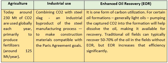
- Productive use of captured CO2: The captured CO2 in CCUS facilities can be used as an input to a range of products and services such as:
Carbon capture, utilization and storage (CCUS) Technologies – a bane?
Despite the benefit that CCUS can help with emission reduction, there are several issues related to the technology and its implementation that still need to be addressed. These disadvantages are:
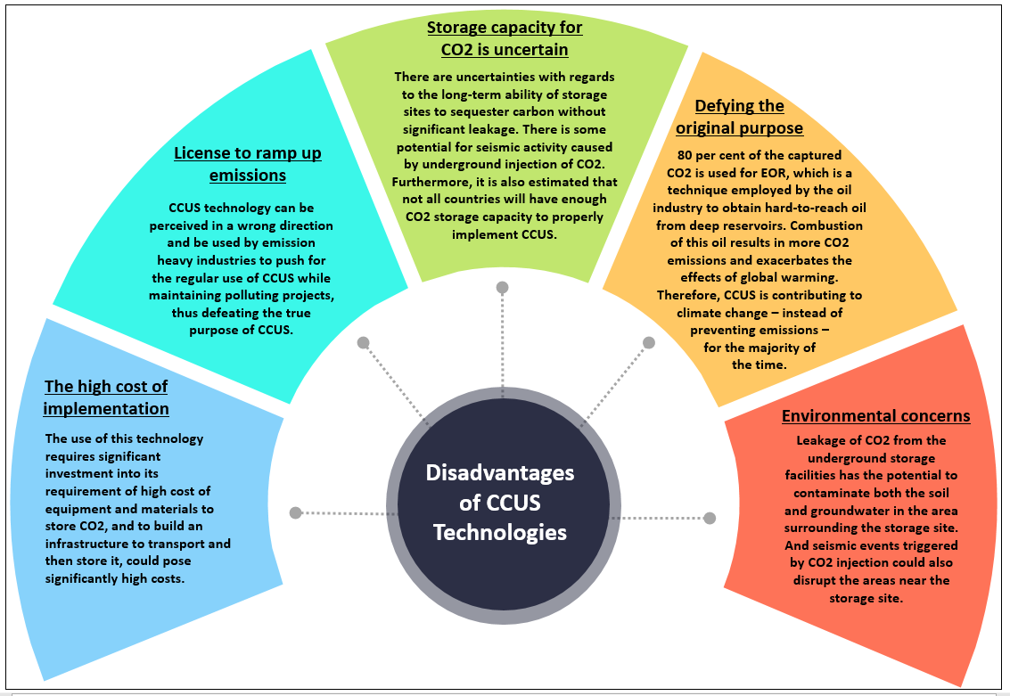
Way forward: Though CCUS technologies help in transition to a low carbon economy, their implementation faces geographical, environmental, social, and political challenges. Hence, a sustainable approach is needed to look beyond the future, identify key risks and mitigations to the challenges identified for a feasible use of CCUS technology.
Where it can be used?
It can be used in topics related to Paper 1 (Climate Change, Sustainable development, Energy crisis), Paper 2 (Energy, sustainable growth and development) and GS 3 (Energy, Environmental Conservation).
Sources:
Megadroughts
In News
According to a new study, the current megadrought in the western United States has been the driest 22-year period in the region in last 1200 years.
What is megadrought?
- Drought can take many forms.
- There’s “meteorological drought,” which compares how much rain or snow has fallen compared to a long-term average.
- There’s “hydrological drought,” which considers how much water flows through streams and rivers and is stored in mountain snowpack and underground aquifers.
- There’s the drought the soil, plants, and animals feel, called agricultural or ecological drought.
- According to the US National Oceanic and Atmospheric Administration, a megadrought is a prolonged drought that spans two decades or longer.
- There may be some wet years in between, but drought impacts remain throughout the period. These are much longer in scale than regular droughts which typically last months or years.
The Megadroughts in Western USA
- Dry conditions are nothing new in the US West, which has cycled through water booms and busts for millennia.
- In the last 1,200-year-long record, the region cycled through 35 major droughts, including four “megadroughts” of particularly notable strength and duration: one in the 800s; another in the 1100s; a third in the 1200s that has been linked to the collapse of Ancestral Pueblo culture in the Southwest; and one deep, intense stretch in the late 1500s that may have added insurmountable strain on Native communities in Mexico already stressed by colonization and disease.
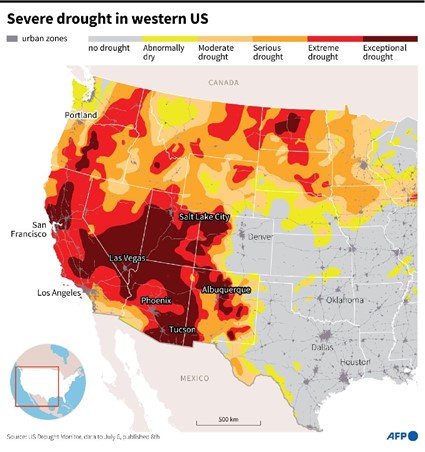
- The drought monitor says 55% of the U.S. West is in drought with 13% experiencing the two highest drought levels.
- This current megadrought kicked off in 2002—one of the driest years ever, based on humidity and tree rings.
- The previous megadroughts lasted decades—“20, 30, even 40 years. This current dry stretch is already long and intense by comparison.
What causes megadroughts?
This year's drought is being caused by two factors: low rainfall the past two years and, over the longer term, human-caused climate change.
- Higher warming in the region: Over the past two decades, temperatures in the Southwest US were around 64 degrees Fahrenheit higher than the average from 1950 to 1999. Globally, the world has warmed by about 2 degrees Fahrenheit since the late 1800s.
- The decreased rainfall is due to a cool episode of La Niña in the tropical Pacific Ocean. La Niña often shifts the jet stream, or storm track, further north, bringing more rain to the Pacific Northwest but starving California and the Southwest of moisture.
- As a result, many areas of Northern California and the Sierra Nevada are experiencing rainfall deficits of well over a foot, with pockets of the mountains near Chico, just northeast of Lake Oroville — an important reservoir — registering a remarkably low rainfall level in recent times.
- Adding to the water stress is a very early melt off of the snowpack in the Sierra Nevada range, which is an important contributor to lake and reservoir levels in the state, typically helping California with its water supply during the dry summer months. In recent spring the snow melted off at a near record pace, two months earlier than normal across the state.
- Climate Change: While natural swings in weather from phenomena like La Niña and El Niño account for most of the year-to-year variation in lake levels and the dryness of vegetation, over the long term, in the background, is the impact of human-caused climate change.
- A 2020 study found that the current Western mega-drought is the second worst in 1,200 years. The study says at least half of this drought can be blamed on a heating climate.
- The burning of fossil fuels releases greenhouse gases, which trap heat and warm the planet. Globally the planet has warmed around 2 degrees Fahrenheit since the 1800s. But certain regions, like the southwestern United States, are warming much faster.
- Warming temperatures are evaporating more moisture from the ground and more quickly melting snowpack, which is decreasing in the West.
- The megadroughts have been occurring throughout history. Long before human industry, water availability ebbed and flowed naturally. That variability, however, has been intensified by the climate crisis.
- According to the recent findings, soil moisture deficits doubled in the last 22 years compared with levels in the 1900s. Human-caused warming accounted for a 42% increase in severity.
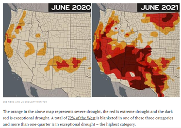
Impacts of Megadroughts
The effects of the ongoing drought are already playing out across many western states.
- Along the California-Oregon border in the Klamath River basin, water reserves are so low that farmers in the region will receive only 8% of the water they usually get.
- The Yurok and Karuk tribes, which steward salmon and other fish populations along the river, are concerned that it won’t have enough water to keep the fish healthy.
- The Colorado River, the source of water for almost 40 million people, is struggling as well. Tribes in the river basin, who have long lacked consistent access to the clean and plentiful water to which they have legal rights, are also feeling the effects of the drought.
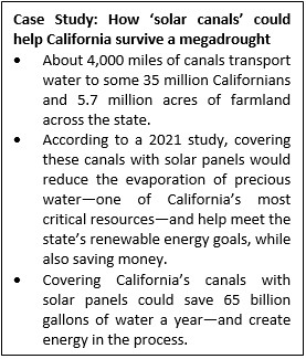
- As of January 2022, Lake Mead, the country’s largest reservoir, is at just 34% of its capacity. The Lake Mead reservoir provides water to 25 million people in southwestern states, including California. In April 2021, California’s governor declared a drought state of emergency, which was expanded last October.
- This situation is forcing officials across states to rethink water management strategies for the years ahead.
- Dry conditions have also increased the risk of wildfires year-round and threatened the livelihoods of farmers and ranchers in the region.
References
- The first megadrought of the 21st century
- West megadrought hits worst-case scenario, now driest in at least 1,200 years
- What is a 'megadrought' and why could this one be even more exceptional for the Western U.S.?
- MEGA-DROUGHT IN THE WEST EXPECTED TO CONTINUE THROUGH THE SUMMER
- Famines and likelihood of consecutive megadroughts in India
- What causes megadroughts?
- US west ‘megadrought’ is worst in at least 1,200 years, new study says
- What is a 'megadrought' and why could this one be even more exceptional for the Western U.S.?
Dry Valley
A dry valley is a valley originally produced by running water but now waterless. In erosional landforms, sometimes, a stream cuts through an impermeable layer to reach a limestone bed. It erodes so much that it goes very deep. The water table is also lowered. Now the tributaries start serving the subterranean drainage and get dried up. These are dry valleys or bournes. Lack of adequate quantities of water and reduced erosion leaves them hanging at a height from the main valley. Thus, they are also referred to as hanging valleys.
Example: chalk dry valleys along the North and South Downs in Southern England.
Key characteristics/features:
- A dry valley may develop on many kinds of permeable rock, such as limestone and chalk, or sandy terrains that do not regularly sustain surface water flow. Such valleys do not hold surface water because it sinks into the permeable bedrock.
- Dry valleys show a considerable range of shapes and sizes, from mere indentations in escarpments, to great winding chasms like Cheddar Gorge in the Mendips.
- Development of Dry valleys? – some may have developed during periods of higher water table, others in periglacial conditions during which normally permeable bedrock would have been made impervious by permafrost, thus allowing flowing water to erode it.
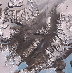
Image: McMurdo Dry Valleys are a row of valleys west of McMurdo Sound, Antarctica
Sources:
Flysch
Flysch are the deposits of marine sandstones, shales, marls and clays produced during the initial uplift of the Alps by sedimentation and later deformation of materials eroded from the uplifted rocks. Flysch refers to any thick succession of alternations of the rocks mentioned above, interpreted as having been deposited by turbidity currents or mass-flow in a deep water environment within a geosynclinal belt.
Examples: Well-known flysch deposits are found in the forelands of the Pyrenees and Carpathians and in tectonically similar regions in Italy, the Balkans and on Cyprus. In the northern Alps, the Flysch is also a lithostratigraphic unit.
Properties of Flysch:
- Flysch consists of repeated sedimentary cycles with upwards fining of the sediments.
- At the bottom of each cycle are sometimes coarse conglomerates or breccias, which gradually evolve upwards into sandstone and shale/mudstone.
- Flysch is formed under deep marine circumstances, in a quiet and low-energetic depositional environment.
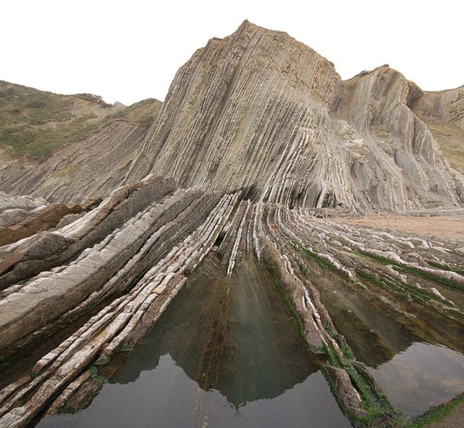
Layers of Flysch on the coast at Zumaia, Spain
Sources:
Climatic Geomorphology
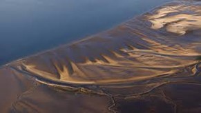
Climatic geomorphology can be defined as the discipline that identifies climatic factors such as the intensity, frequency and duration of precipitation, frost intensity, direction and power of wind, and it explains the development of landscapes under different climatic conditions. Simply put, it is the study of the role of climate in shaping landforms and the earth-surface processes.
Features:
- Being often concerned about past climates climatic geomorphology considered sometimes to be an aspect of historical geology.
- Climatic geomorphologists have devised various schemes that divide Earth's surface into various morphoclimatic zones; that is, zones where landforms are associated to present or past climates.
- An approach used in climatic geomorphology is to study relict landforms to infer ancient climates.
Sources:
Wastewater treatment technologies to save the waterbodies: Aurangabad Maharashtra
Background
- The 65-km Kham River flows through Aurangabad, Maharashtra. Leakage from sewage systems, indiscriminate encroachment and dumping of solid waste has reduced the once seasonal river into a perennial flow of garbage.
- In 2020, EcoSattva, an Aurangabad-based organisation, started restoring Kham. The company works on treating wastewater or reusing water to support their projects related to green cover enhancement.
- The revival of the Kham River in Aurangabad, Maharashtra is a fine example of how wastewater treatment technologies can be used to save the country’s waterbodies.

About the Work by EcoSattva
- The programme helped one understand the fundamental principles of water conservation and decentralised wastewater treatment systems, exposure to ecologically sound water management systems and to become a part of the network of practitioners.
- The Ecologic Sewage Treatment Plants (EcoSTPs) built by EcoSattva offer a sustainable solution, which also has a positive environmental impact. In the EcoSTPs, an ecological system is created that speeds up the natural treatment process by using enzymes, plants, microorganisms and sunlight. It has zero power consumption and no maintenance cost.
- The project has been designed with a holistic approach that focuses on restoring and maintaining the health of the river through a long-term commitment from the residents, private and public sector stakeholders. All the restoration efforts have been based on research and application of appropriate technological, social, infrastructural and governance solutions.
- Sewage contains 99 per cent of water and rest of 1 per cent has suspended solids, bacteria and other things. This huge amount of treated water can be used for gardening, washing and other non-potable purposes.
Result of the Intervention
- In the first year, the company worked to restore 11.9 kilometres upstream of the river and 7.6 km flowing by 30 wards of the city. With the help of a drone survey, 249 points were identified, where untreated sewage emptied into the riverbed along with 16 fresh water springs in it.
- Riverfront redevelopment and creation of public spaces helped give visibility to the project. Kham restoration was also included in the Namami Gange project, with EcoSattva working closely with the civic body.
- The story of Kham and its rebirth sets an example for other cities and civic bodies, who are grappling with the rising pollution levels in their rivers.
Source:
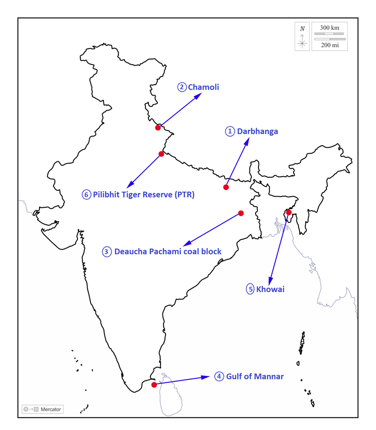
Places in news
|
Darbhanga
|
|
Chamoli
|
|
Deaucha Pachami coal block
|
|
Gulf of Mannar
|
|
Khowai
|
|
Pilibhit Tiger Reserve (PTR)
|
Share the article
Get Latest Updates on Offers, Event dates, and free Mentorship sessions.

Get in touch with our Expert Academic Counsellors 👋
FAQs
Geography Current Affairs focuses on the contemporary issues, events, and developments in the field of geography. It covers recent geographical phenomena, environmental changes, geopolitical shifts, and related news. This differs from regular geography studies which may focus more on foundational concepts, historical contexts, and theoretical frameworks.
Updates are provided regularly to ensure that subscribers stay informed about the latest developments in geography. Typically, updates are provided on a fortnightly basis, depending on the frequency of significant events and changes in the field.
Absolutely. Geography Current Affairs serves as a valuable resource not only for Geography optional but also for GS papers, especially GS Paper 1 (covering Indian Heritage and Culture, History, and Geography of the World and Society) and GS Paper 3 (covering Technology, Economic Development, Biodiversity, Environment, Security, and Disaster Management). It aids in building a holistic understanding of various topics and strengthens answer-writing skills by incorporating contemporary examples and perspectives.
Geography Current Affairs holds immense importance for UPSC preparation, particularly for aspirants opting for Geography optional. It helps candidates stay updated with the latest developments, geographical phenomena, environmental issues, and geopolitical shifts worldwide, aligning them with the dynamic nature of the subject as tested in the UPSC examinations.

