
10 Sep to 24 Sep, 2025
SEA LEVEL RISE
Why in news : A study on coral microatolls in the Maldives shows that sea-level rise in the central Indian Ocean began earlier and progressed faster than previously thought, challenging the belief that significant rise started in the 1990s, with major implications for climate science and coastal policy.
About :
Key Observation
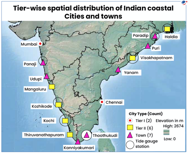
- Maximum Sea Level Rise (SLR): Maximum SLR over the past three decades (1991–2020) was observed at the Mumbai station (4.44 cm), followed by Haldia (2.72 cm), Visakhapatnam (2.38 cm), etc.
- Submergence due to rise in sea levels by 2040: More than 10% of the land in Mumbai, Yanam, and Thoothukudi; 5%–10% in Panaji and Chennai; and 1%–5% in Kochi, Mangaluru, Visakhapatnam, Haldia, Udupi, Paradip, and Puri would be submerged due to rise in sea levels by 2040.
Factors for Sea Level Rise (SLR)
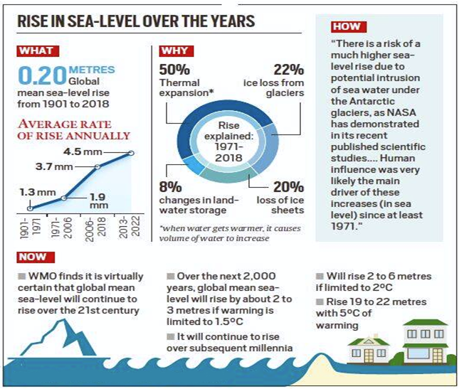
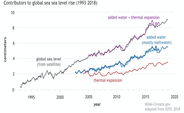
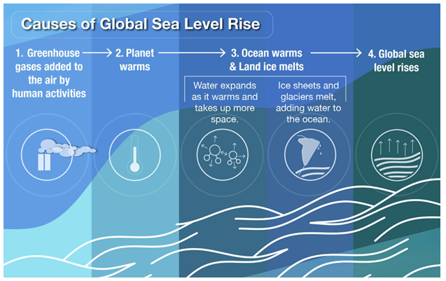
- Ocean thermal expansion: Oceans absorb more than 90% of the heat trapped by accumulating greenhouse gases (GHGs), leading to temperatures increase and expansion of water.
- Ice melting: The melting of ice from glaciers, ice caps, and ice sheets in Greenland and Antarctica is another cause of SLR.
Impacts of Sea Level Rise (SLR)
- Increased Coastal Erosion : Sea level rise intensifies coastal erosion through stronger waves, storm surges, and flooding.As per the National Centre for Coastal Research (NCCR), 32% of India’s coastline experienced erosion between 1990–2018, with West Bengal, Kerala, and Tamil Nadu worst affected.The Sunderbans delta is shrinking rapidly, threatening villages and mangrove habitats.
- Coastal Inundation and Flooding : Low-lying coastal regions face recurring inundation due to tidal surges and permanent submergence.Example: In India, cities like Mumbai, Chennai, and Visakhapatnam are listed among the top 20 global coastal cities most exposed to annual flooding by 2050 (World Bank, 2019).
- Freshwater Salinization : Rising seas intrude into freshwater aquifers, rivers, and agricultural lands.The Chilika Lake region in Odisha and the Mahanadi delta are experiencing saline intrusion, affecting paddy cultivation.
- Coastal Community Displacement : Permanent flooding displaces populations, creating “climate refugees.”Example: The island of Ghoramara in West Bengal has lost nearly half its landmass, forcing hundreds of families to migrate to mainland areas like Sagar Island.
- Coastal Habitat Loss : Rising seas threaten ecosystems such as mangroves, salt marshes, and coral reefs.Example: The Gulf of Mannar coral reefs are under threat, while mangroves in the Sundarbans are being submerged, reducing their role as carbon sinks and storm buffers.
- Infrastructure Vulnerability : Coastal infrastructure like ports, airports, and urban settlements face higher flood risks.Example: Chennai’s Ennore Port and Kochi’s infrastructure are at risk of inundation, requiring costly climate-resilient engineering.
Effect of Sea Level Rise on Island Nations
- Existential Threat: Low-lying islands risk submergence. Maldives (80% land <1m above sea level) could be uninhabitable by 2100 (IPCC).
- Displacement & Migration: Kiribati purchased land in Fiji (2014) to relocate citizens.
- Freshwater Salinization: Atoll nations like Tuvalu face loss of potable water due to saline intrusion.
- Economic Impact: Tourism and fisheries—the backbone of island economies—are disrupted. Caribbean nations face rising coastal damages (World Bank, 2020).
- Habitat Loss: Coral reefs in Pacific islands may decline 70–90% by 1.5°C warming, weakening natural storm protection.
Vulnerability of India:
- India's 11098 kilometre-long coastline accounts for 90% of the country's trade and it spans 3,331 coastal villages and 1,382 islands.
- Long coastline: 7,516 km across 9 states & 4 UTs; 32% eroding (NCCR).
- Densely populated coasts: ~260 million people live within 50 km of coast; Mumbai, Chennai, Kolkata among world’s most exposed cities.
- Deltaic risk zones: Sundarbans, Mahanadi, Godavari, Krishna deltas highly prone to inundation and salinization.
- Island fragility: Lakshadweep & Andaman–Nicobar atolls face existential threat, coral reef decline, and freshwater scarcity.
- Economic hubs exposed: ~70% of India’s ports, oil refineries (Jamnagar, Paradip), and SEZs lie in low-elevation zones.
- Agriculture & fisheries: Paddy fields in Chilika basin (Odisha) and aquifers in Kuttanad (Kerala) suffering saline intrusion.
- Cultural heritage: Coastal monuments like Konark Sun Temple (Odisha) & Mahabalipuram (TN) threatened by erosion and flooding.
|
Case Study: Maldives – “Existential Threat from Rising Seas” Maldives, an island nation in the Indian Ocean, has 80% of its land less than 1 metre above sea level. Threat: IPCC (2021) projects global SLR of 0.29–1.1 m by 2100. Even moderate rise could submerge large parts of Maldives. Impact:
Response:
|

Steps taken by Government of India
- Central Water Commission Guidelines (2020): Provide design norms for coastal protection works.Sea walls in Kerala’s Alappuzha & Thiruvananthapuram built as per guidelines to check beach erosion.
- Coastal Vulnerability Index (CVI): Assesses erosion risk using 7 parameters.CVI shows Odisha, West Bengal, Gujarat most vulnerable; Sundarbans delta rated “very high risk.”
- National Disaster Response Fund (NDRF): ₹1000 crore earmarked for resettlement of erosion-affected people.Example: Families displaced from Ghoramara Island, West Bengal received relocation aid under NDRF window.
- Coastal Regulation Zone (CRZ) Notification, 2019: Restricts construction, protects ecosystems, and secures fisher livelihoods.
Example: Mumbai’s mangrove buffer zones declared “No Development Zone” under CRZ to curb erosion and flooding. - MISHTI (2023–24): Targets 540 sq. km mangrove restoration across 11 states/2 UTs.Example: Sundarbans (WB), Bhitarkanika (Odisha), Pichavaram (TN) identified for plantation drives.
- Shelterbelt Plantations: Tree rows absorb wind and wave energy.
Example: Casuarina plantations in Ramanathapuram (TN) & Odisha coast significantly reduced cyclone-driven erosion.
Adaptation strategies for Sea-level rise
- Build flood barriers to protect infrastructure:
- Ecosystem-based coastal protection: E.g., Oyster beds along the coast can serve as natural breakwaters.
- Man Made structures: E.g., seawall is a structure made of concrete, masonry or sheet piles.
- Conduct sea-level rise and storm surge modelling: Modelling sea-level rise and storm surge dynamics will better inform the placement and protection of critical infrastructure.
- Floating Cities: Development of these cities started in Maldives and South Korean which will be flood proof.
- Integrated Coastal Zone Management: Aim to promote security of life and livelihood of coastal communities, protect coastal ecosystems and to promote sustainable development.
- Push for a Climate Action Plan: Many cities and states do not have plans to address climate change, which is the primary cause of current sea level rise.
Source : https://www.climate.gov/news-features/understanding-climate/climate-change-global-sea-level
Where to use ?
Paper I ( Geography Optional ) : Oceanography ( Sea level rise ) , Global Warming and Effects
ENVIRONMENT AUDIT RULES 2025
Why in news : The Ministry of Environment, Forest and Climate Change (MoEFCC) has notified the Environment Audit Rules, 2025 under the Environment (Protection) Act, 1986, to establish a comprehensive framework for environmental accountability across India.
About :
What is an Environmental Audit?
An environmental audit is a structured, periodic, and impartial process that reviews whether an organisation, project, or facility complies with environmental laws and sustainability norms.Example: A thermal power plant may be audited for compliance with emission standards under the Air Act, 1981.
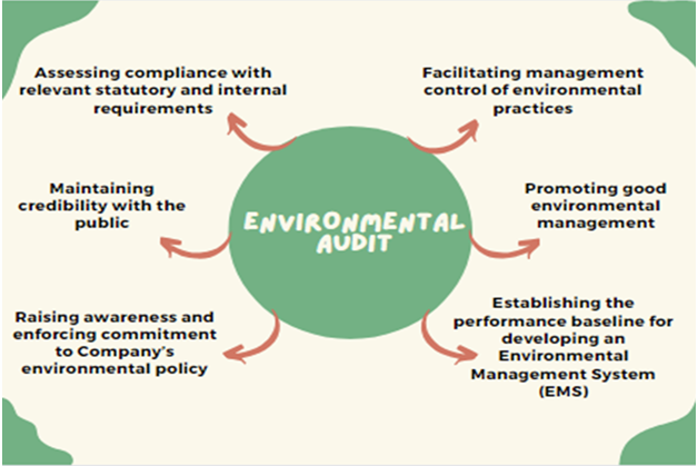
Types of Environmental Audits
- Compliance Audit: Verifies adherence to laws such as the Environment Protection Act, 1986 and Waste Management Rules.
- Management Audit: Evaluates internal policies and sustainability frameworks.
- Functional/Activity Audit: Examines specific operations like water use, effluent discharge, or hazardous waste handling.
Why is an Environmental Audit Necessary?
- Ensures Legal Compliance: Prevents violations, fines, and disputes under Air, Water, and Environment Protection Acts.
- Protects Human Health & Environment: Tracks pollution, waste disposal, and safety measures to safeguard communities.Example: Post-LG Polymers Vizag gas leak (2020), audits gained urgency.
- Promotes Transparency & Accountability: Provides verified performance data, curbing “greenwashing.”
- Supports Sustainable Development: Identifies inefficiencies, saves energy, and promotes clean technology adoption.
- Facilitates Competitiveness: Essential for global trade; ISO 14001 or ESG audits required in international supply chains.
- Risk Management: Detects hazards early, reducing chances of industrial disasters like Bhopal Gas Tragedy (1984).
- Supports Climate Goals: Measures emissions and carbon footprints, aiding India’s Net Zero by 2070 targets.
Why New Environmental Audit Rules Were Needed
India earlier relied mainly on inspections by the CPCB and SPCBs, but the system was weak due to:
- Shortage of staff and resources.
- Dependence on consultants hired by industries themselves (conflict of interest).
- Poor quality and inconsistency of compliance reports.
- Rising industrialisation and urbanisation straining monitoring capacity.
New rules propose an independent, accredited auditor-based system to strengthen accountability and complement regulatory oversight.
Main Features of Environment Audit Rules, 2025
Environment Audit Designate Agency (EADA)
- Centralised body to certify, register, train, and oversee auditors.
- Ensures uniform auditing standards nationwide.
Registered Environment Auditors (REAs)
- Only certified REAs can conduct audits, selected via random allocation to avoid collusion.
- Certification based on qualification/experience or examination.
Responsibilities of REAs
- Sampling and analysis of air, water, soil.
- Audit compliance under waste management, forest, wildlife, and environment laws.
- Verify Green Credit Rules (carbon/ecological credits).
- Calculate damages in cases of environmental harm.
Two-Tier Compliance System
- Tier-1: CPCB/SPCBs and MoEFCC review.
- Tier-2: Independent verification by REAs → ensures dual checks.
Oversight
- A Steering Committee (led by MoEFCC Additional Secretary) monitors progress, resolves disputes, and suggests reforms.
Expected Benefits
- Stronger compliance checks, especially in remote areas.
- Transparent, standardised audits improve ease of doing business.
- Random auditor assignment ensures accountability.
- Supports circular economy by integrating with Green Credit and waste rules.
Challenges
- Need for trained auditors at scale.
- Risk of overlap between regulators and REAs.
- Enforcement must ensure audit findings lead to penalties/corrective action.
Industries may initially resist due to compliance costs.

Conclusion
The 2025 Rules modernise India’s environmental governance by blending regulator oversight with independent auditing. If implemented effectively, they can boost transparency, accountability, and help India meet global climate and sustainability commitments.
Where to use ?
Paper I ( General Studies ) : Environment legislations
GREATNICOBAR PROJECT
Why in News?: Great Nicobar Island (GNI) Project has drawn attention as one of India’s most ambitious infrastructure plans in the Indian Ocean Region (IOR).
About :
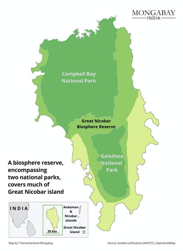
Great Nicobar Island (GNI) Project – Overview
Launched in 2021, the Great Nicobar Island Project is a mega-infrastructure plan at the southern tip of the Andaman & Nicobar Islands. It includes:
- International Container Trans-shipment Terminal (ICTT) at Galathea Bay.
- Greenfield international airport, township development, and a 450 MVA gas & solar power plant.
- Implemented by ANIIDCO, based on a NITI Aayog report highlighting its strategic location (midway between Colombo, Port Klang, and Singapore).
Strategic Significance
- Near the Malacca Strait, one of the world’s busiest sea lanes (like Panama Canal for global trade).
- Enhances India’s maritime security, allowing deployment of warships, missile batteries, and aircraft.
- Counters China’s growing presence in the Indo-Pacific (e.g., China’s military facility on Myanmar’s Coco Islands, ~55 km from Indian territory).
- Strengthens India’s role in the Bay of Bengal–Indian Ocean Region (IOR), critical for trade and energy routes.
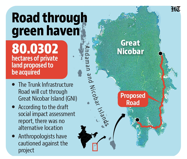
Challenges
- Impact on Tribes
- The Shompen and Nicobarese (PVTGs, population just a few hundred) depend on forests and ecosystems.
- Project risks displacing them and violates the Forest Rights Act, 2006, which empowers them to manage tribal reserves.
- Example: Similar displacement pressures were seen with Jarawa tribe in Middle Andamans due to the Andaman Trunk Road.
- Ecological Concerns
- Nearly 1 million trees to be felled in a unique rainforest.
- Threats to leatherback turtles and Nicobar megapode bird at Galathea Bay.
- Coral reefs at risk, similar to damage seen near Lakshadweep due to port and tourism expansion.
- Seismic Vulnerability
- GNI is in a high-risk seismic zone; in 2004 tsunami, the island subsided ~15 feet.
- Raises doubts about viability of large ports and airports in disaster-prone areas.
- Governance Issues
- Insufficient consultation with local Tribal Councils.
- Although NGT (2023) upheld environmental clearance, it asked for a high-power monitoring committee.
Way Forward:
- Tribal Inclusion: Involve Great & Little Nicobar Tribal Councils in decision-making, respecting rights under the Forest Rights Act (2006).
- Oversight Mechanism: Set up an NGT-mandated high-power committee with tribal, environmental, and independent experts to monitor clearances.
Conclusion
The GNI Project aims to make India a maritime hub like Singapore, but faces trade-offs: strategic gains vs. ecological risks and tribal rights violations. The debate reflects the larger dilemma of development vs. sustainability in fragile ecosystems.
Source :
Paper II ( Geography Optional ) : Regional Planning
Where to use ?
Green, Social, and Sustainability Bonds
Green, Social, and Sustainability Bonds: These are debt instruments used to raise funds for projects with positive environmental and social impacts. Green bonds finance renewable energy, clean transport, and climate projects. Social bonds support affordable housing, healthcare, and education. Sustainability bonds combine both purposes, ensuring balanced outcomes. They have gained traction in India and globally as tools for financing Sustainable Development Goals (SDGs). By channeling private capital into public-good projects, they create accountability, transparency, and long-term environmental and social benefits.
Blood Moon
Blood Moon : A blood moon occurs during a total lunar eclipse when Earth’s shadow falls on the Moon. Instead of going completely dark, the Moon takes on a reddish hue because sunlight bends through Earth’s atmosphere, filtering out shorter blue wavelengths and allowing longer red ones to reach the Moon. This rare astronomical event carries cultural and ecological significance. For instance, ancient societies linked it to omens, while today it helps scientists study Earth’s atmospheric dust, pollution, and climate patterns indirectly.
Bioproducts
Bioproducts: Bioproducts are materials, chemicals, and fuels derived from renewable biological resources like plants, algae, or microorganisms, rather than fossil fuels. Examples include bioplastics, bioethanol, and bio-based fertilizers. They reduce carbon footprints, enhance energy security, and align with circular economy goals. Countries are promoting bioproducts to cut reliance on petroleum, tackle waste, and generate rural employment through bio-based industries. India’s bio-CNG and ethanol-blending programs illustrate how bioproducts can integrate sustainability with economic growth and energy diversification.
Ecological Indicators
Ecological Indicators: Ecological indicators are measurable species, processes, or environmental variables that reflect ecosystem health and stability. For example, lichens indicate air quality, while amphibian populations reveal freshwater ecosystem conditions. Indicators can be biological (species diversity), chemical (nutrient levels), or physical (temperature, turbidity). Policymakers use them to assess biodiversity loss, pollution impacts, and conservation effectiveness. By translating complex ecological changes into observable signals, indicators help monitor progress toward sustainability and guide adaptive management strategies in conservation planning.
High Sea
High Seas: High seas refer to ocean areas beyond national jurisdiction, covering nearly 64% of Earth’s oceans. They are rich in biodiversity, carbon sinks, and vital fish stocks but face threats from overfishing, plastic pollution, and deep-sea mining. Governance is fragmented under international law, primarily UNCLOS (United Nations Convention on the Law of the Sea). Recently, the 2023 UN High Seas Treaty aims to protect marine biodiversity and establish marine protected areas. Sustainable management of high seas is crucial for climate stability and food security.
DAIRY FARMING IN NEWZEALAND
- New Zealand is one of the world’s largest exporters of dairy products, despite having a population of just ~5.1 million.
- Dairy contributes nearly 3.5% of New Zealand’s GDP and about 20% of total merchandise exports (2022).
- The sector is dominated by Fonterra Co-operative Group, a farmer-owned multinational controlling around 30% of the world’s dairy exports.
Major Dairy Regions
- Waikato (North Island) – known as the "dairy heartland," with lush pastures due to high rainfall.
- Canterbury Plains (South Island) – large-scale, irrigated dairy farms with high productivity.
- Taranaki (around Mount Taranaki) – long tradition of dairy farming, smaller family-run farms.
Facts & Data
- New Zealand has 4.8 million dairy cows (2021), nearly equal to its human population.
- Average herd size: ~440 cows per farm, compared to ~100 in the 1980s.
- Milk production (2021–22): 21 billion liters, with most processed into milk powder, butter, and cheese for export.
- Key export markets: China (largest buyer), Southeast Asia, Middle East.
- Example: In 2020, 95% of New Zealand’s milk production was exported, unlike India, where most dairy is consumed domestically.
Environmental Concerns
- High methane emissions from cattle → contributes to New Zealand’s greenhouse gas challenges.
- Water pollution from nitrate leaching and over-irrigation in Canterbury.
Where to use ?
Paper II ( Geography Optional) : Agriculture and Dairy
Places in News - 24 September 2025
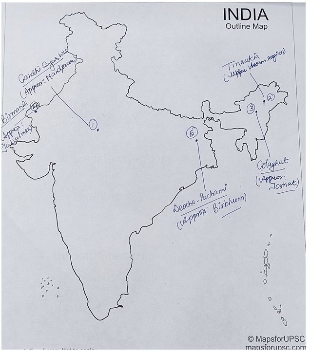
1. Gandhi Sagar WLS
Why in news : Madhya Pradesh plans to introduce a female cheetah to Gandhi Sagar Wildlife Sanctuary, aiming to establish it as a second home for cheetahs after Kuno National Park, as a part of Project Cheetah.
About :
- Situated in northwestern Madhya Pradesh, bordering Rajasthan, within the Khathiar-Gir dry deciduous forests ecoregion.
- Ecosystem: Gandhi Sagar Wildlife Sanctuary features savanna, open grasslands, dry deciduous forests, and riverine areas. It is recognized as an Important Bird and Biodiversity Area (IBA).
- Topography: Includes hills, plateaus, and the Gandhi Sagar Dam and the Chambal River (tributary of the Yamuna) bifurcates the sanctuary into two nearly equal parts.
- Flora: Dominated by Khair, Salai, Tendu, and other dry deciduous species.
- Fauna: Home to Chinkara, Nilgai, Indian Leopard, Hyena, and more.
- Historical Sites: The sanctuary includes sites like Chaurasigarh, Chaturbhuj Nala rock shelters, Bhadkaji rock paintings, and Hinglajgarh Fort.
2. Tinsukia
Why in news: The Moran community in Assam’s Tinsukia district—an area rich in oil, coal, and tea—has launched an economic blockade, stopping the movement of goods to and from the region to press their demand for Scheduled Tribe (ST) status.
About :
- It is an industrial city, situated 480 kilometres north-east of Guwahati and 84 kilometres away from the border with Arunachal Pradesh.
- It serves as the headquarters of the Moran Autonomous Council, which is the governing council of the Morans.
- It is linked by highway with northwestern Myanmar (Burma) to the east and, via Dibrugarh, with Guwahati and Shillong to the southwest.
3. Golaghat
Why in news : The Prime Minister inaugurated India’s first bamboo-based bioethanol plant in Golaghat, Assam, marking a major step toward energy self-sufficiency and green energy promotion.
About :
- It is one of the largest subdivisions ,a city and a municipality and the seat of administrative operations of Golaghat district, besides being a twin city.
- The Dhansiri, one of the tributaries of the Brahmaputra, passes through Golaghat and is the primary water source for its citizens.
4. Birmania
Why in news : Union Environment Ministry’s Expert Appraisal Committee (EAC) has approved an Environmental Impact Assessment (EIA) for the Birmania Rock Phosphate Mine, which is proposed to be developed in the potential habitat area of the Great Indian Bustard (GIB) in Jaisalmer, Rajasthan.
About :
- It is a proposed rock phosphate mining project in the Fatehgarh tehsil of the Jaisalmer district, Rajasthan
- The project is being developed by FCI Aravali Gypsum And Minerals India Limited and is currently in the conceptual/planning stage.
- The proposal has raised concerns because the mining area is located in a critical habitat for the Critically Endangered Great Indian Bustard (GIB), leading to a debate between the need for fertilizer raw materials and the preservation of wildlife.
5. Deocha-Pachami
Why in news : Work on the Deocha Pachami Coal Mining project in West Bengal's Birbhum district recently
About :
- It is India's largest coal mine located in the south-western part of Birbhum Coalfield in West Bengal.
- It spreads over approximately 10 sq km, in-place reserves of coal is estimated at 2,100 million tonnes with an investment potential of Rs. 20,000 crore (US$ 3 billion).
Fortnightly KOSMOS MCQs Practice - 25th September 2025
Q1. Regarding the Korku tribal community, consider the following statements:
1. It is a Scheduled Tribe that mostly lives in Maharashtra and Madhya Pradesh.
2. This tribe has a nearly lost language, Korku, which lacks its own script and is written in Devanagari or English.
Which of the statements given above is/are correct?
- Only 1
- Only 2
- Both 1 and 2
- Neither 1 nor 2
Q2. Consider the following statements:
1. It is also known as the Euxine Sea and is one of the major water bodies and a famous inland sea of the world.
2. It is bordered by Ukraine to the north and northwest, Russia and Georgia to the east, Türkiye to the south, and Bulgaria and Romania to the west.
3. It is also connected to the Sea of Azov by the Strait of Kerch.
Which of the following water bodies best matches the above description?
- Caspian Sea
- Black Sea
- Baltic Sea
- Adriatic Sea
Q3. Which organisation recently released the World Population Prospects 2024 Report?
- United Nations Population Fund (UNFPA)
- United Nations Department of Economic and Social Affairs (UNDESA)
- United Nations Development Programme (UNDP)
- World Bank
Q4. Consider the following statements:
1. It is a transboundary basin distributed between Brazil, Peru Colombia, and Ecuador.
2. It is by far the largest river basin in the world.
3. This basin contains the highest biodiversity in the world.
Which of the following basins best matches the above description?
- Amazon Basin
- Congo Basin
- Mekong Basin
- Ganges-Brahmaputra-Meghna Basin
Q5. Consider the following:
1. It is located south of the Narmada River.
2. It comprises Bori Sanctuary and Pachmarhi Sanctuary.
3. It is also known for the presence of more than 50 rock shelters with paintings which are 1500 to 10,000 years old.
Which of the following protected areas best matches the above description?
- Satpura Tiger Reserve
- Kanha Tiger Reserve
- Bandhavgarh National Park
- Panna National Park
Q6. Regarding the Rare earth elements (REEs), consider the following statements:
1. They are a group of 17 chemical elements in the periodic table, specifically the 15 lanthanides along with scandium and yttrium.
2. They are relatively abundant in the Earth's crust but are rarely found in concentrations that can be economically exploited.
3. India has the highest reserves of all the REEs in the world followed by China.
How many of the statements given above is/are correct?
- Only One
- Only Two
- All Three
- None
Q7. Regarding the Compensatory Afforestation Fund (CAF), consider the following statements:
1. The CAF Act, 2016 was enacted to manage funds previously handled by the Compensatory Afforestation Fund Management and Planning Authority (CAMPA).
2. Compensatory afforestation requires planting forests on non-forest land or degraded forest land in place of diverted forest land.
3. 10% of the CAF money is allocated to states, while 90% is retained by the Centre.
Which of the above statements is/are correct?
- 1 and 2 only
- 2 and 3 only
- 1 and 3 only
- 1, 2, and 3
Q8. Svalbard Global Seed Vault is best described as:
- A research facility for studying the impact of climate change on seeds.
- A secure facility designed to store and preserve seeds from around the world.
- A laboratory focused on the genetic modification of plants.
- An international treaty organisation for agricultural development.
Q9. Consider the following statements:
1. They are the largest member of the dolphin family.
2. They use echolocation to communicate and hunt.
3. Each of their group has distinctive noises.
Which of the following fish best matches the above description?
- Orca (Killer Whale)
- Humpback Whale
- Blue Whale
- Beluga Whale
Q10. Consider the following statements:
Statement-I: The Stockholm Convention is a global treaty to protect human health and the environment from Persistent Organic Pollutants (POPs).
Statement-II: POPs are organic compounds that resist degradation by environmental processes such as chemical breakdown, biological processes, and sunlight and can disrupt the endocrine system.
Which one of the following is correct in respect of the above statements?
- Both Statement-I and Statement-II are correct and Statement-II is the correct explanation for Statement I
- Both Statement-I and Statement-II are correct and Statement-II is not the correct explanation for Statement-I
- Statement-I is correct but Statement-II is incorrect
- Statement-I is incorrect but Statement-II is correct
Share the article
Edukemy’s Current Affairs Quiz is published with multiple choice questions for UPSC exams
MCQ
Get Latest Updates on Offers, Event dates, and free Mentorship sessions.

Get in touch with our Expert Academic Counsellors 👋
FAQs
Geography Current Affairs focuses on the contemporary issues, events, and developments in the field of geography. It covers recent geographical phenomena, environmental changes, geopolitical shifts, and related news. This differs from regular geography studies which may focus more on foundational concepts, historical contexts, and theoretical frameworks.
Updates are provided regularly to ensure that subscribers stay informed about the latest developments in geography. Typically, updates are provided on a fortnightly basis, depending on the frequency of significant events and changes in the field.
Absolutely. Geography Current Affairs serves as a valuable resource not only for Geography optional but also for GS papers, especially GS Paper 1 (covering Indian Heritage and Culture, History, and Geography of the World and Society) and GS Paper 3 (covering Technology, Economic Development, Biodiversity, Environment, Security, and Disaster Management). It aids in building a holistic understanding of various topics and strengthens answer-writing skills by incorporating contemporary examples and perspectives.
Geography Current Affairs holds immense importance for UPSC preparation, particularly for aspirants opting for Geography optional. It helps candidates stay updated with the latest developments, geographical phenomena, environmental issues, and geopolitical shifts worldwide, aligning them with the dynamic nature of the subject as tested in the UPSC examinations.