
24 Mar to 10 Apr, 2026
GREEN PATHWAY
Why in news : In the 21st century, the relationship between development and the environment has moved from the margins of policy debate to the centre of national decision-making.
About:
Introduction: Shifting Paradigm
Earlier development models—especially after World War II—focused on rapid industrialization, GDP growth, and infrastructure expansion. Environmental costs were treated as “externalities.”
- Example: Coal-based industrial growth in Europe and North America boosted output but caused severe air and water pollution.
- Large dams and mining projects often ignored ecological balance and displacement issues.

21st Century Shift: Environment at the Core
In the 21st century, environmental concerns have moved to the centre of policy-making. Governments now integrate sustainability into planning.
- Example: India’s renewable energy push and climate commitments under global agreements.Urban policies now include green infrastructure, waste management, and emission control.
👉 Development is increasingly seen as environment + economy + society together, not separately.
Key Global Triggers
- Climate Change: Rising temperatures, extreme events (heatwaves, floods).
- Biodiversity Loss: Rapid species extinction, ecosystem collapse (e.g., Amazon deforestation).Pollution Crises: Air pollution in cities like Delhi and water contamination globally.
👉 These crises exposed the unsustainability of earlier growth models.
Emergence of Sustainable Development
The United Nations popularized the idea of sustainable development—meeting present needs without harming future generations.
- Institutionalized through frameworks like the Sustainable Development Goals.Example: Promoting clean energy, responsible consumption, and climate action.
👉 It emphasizes balance, equity, and long-term ecological stability.
|
Concept |
Key Dimensions & Explanation |
|
Development |
Economic: Growth in production and income (e.g., GDP rise in emerging economies). • Social/Human: Education, health, gender equality (measured through HDI by United Nations Development Programme). • Spatial: Balanced regional development, reducing rural–urban disparities. 👉 Example: A region with high GDP but poor healthcare reflects uneven development. |
|
Environment |
Lithosphere (land), Hydrosphere (water), Atmosphere (air), Biosphere (life). • Provides Ecosystem Services: – Provisioning: Food, water, timber. – Regulating: Climate control (e.g., forests absorbing CO₂). – Cultural: Recreation, spiritual values. 👉 Example: Mangroves protect coastal areas from cyclones and support fisheries |
|
Sustainable Development |
Defined by Brundtland Commission: Meeting present needs without compromising future generations. • Intergenerational Equity: Resource conservation for future. • Intra-generational Equity: Fair distribution within present society. 👉 Example: Solar energy reduces pollution and ensures long-term energy security. |
Why the Shift to the Centre of Decision Making ?
a) Climate Change
Rising global temperatures, extreme weather events (heatwaves, floods, cyclones), and sea-level rise have made environmental risks immediate.
- Impacts: crop failure, water stress, displacement.
- Example: Frequent heatwaves in Delhi and coastal flooding risks in low-lying regions.
👉 Climate change directly threatens economic stability and human survival, forcing policy prioritization.
b) Resource Depletion
Over-exploitation of fossil fuels, groundwater, and forests has created scarcity.
- Example: Groundwater crisis in north-west India due to over-irrigation.
- Energy insecurity due to dependence on non-renewables.
👉 Development without resource conservation proved unsustainable in the long run.
c) Biodiversity Loss
Rapid species extinction (often termed the “sixth mass extinction”) is disrupting ecosystems.
- Example: Deforestation in Amazon Rainforest affecting global climate regulation.
👉 Loss of biodiversity weakens ecosystem resilience and services essential for life.
d) Urbanization & Industrialization
Unplanned growth has increased pollution, waste generation, and ecological footprints.
- Example: Air pollution crisis in megacities like Beijing.
👉 Cities became hotspots where development–environment conflict is most visible.
e) Disasters & Risk Geography
Rising frequency of climate-induced disasters (cyclones, floods, landslides) has increased vulnerability.
- Example: Intensifying cyclones in the Bay of Bengal region.
👉 Shift toward risk-informed development planning.
f) Technological & Scientific Advancements
- Satellite data, climate models, GIS revealed real-time environmental degradation.
👉 Better evidence pushed governments toward action.
g ) Economic Realization (Green Economy)
- Recognition that environmental damage leads to long-term economic losses.
👉 Shift toward renewable energy, sustainable industries.
Key Policy Debates
The "centrality" of the environment in decision-making is often a site of intense conflict:
- Growth vs. Conservation: A classic debate where industries argue that strict regulations (like high carbon taxes) hamper global competitiveness and jobs, while environmentalists argue that "business-as-usual" leads to irreversible ecological collapse.
- Polluter Pays vs. Public Burden: In the past, the costs of pollution were often "shared" by society (e.g., poor public health). Modern debate focuses on the Polluter Pays Principle, shifting the financial burden of cleanup and mitigation directly to the companies responsible.
- Intergenerational Justice: Policymakers debate how to value the needs of future generations against the immediate needs of the current population, especially in developing nations where poverty alleviation is urgent
Core Approaches to Environmental Policy
Modern policy is increasingly shaped by three primary philosophical and practical frameworks:
- Anthropocentric (Human-Centered): Views nature primarily as a resource to support human welfare. Policies focus on managing risks to human health (e.g., air quality standards) and long-term resource availability for industry.
- Biocentric (Nature-Centered): Argues that all living beings have intrinsic value regardless of their utility to humans. This approach drives policies like the creation of strict wildlife preserves and rewilding projects where human activity is prohibited.
- Ecological Modernisation: A dominant middle-ground approach that seeks "win-win" solutions by using technology and market-based tools to decouple economic growth from environmental harm.
Incidents that Changed Global Outlook
These specific incidents transformed how governments write laws and how companies operate.
|
Incident |
Key Outcome / Policy Change |
|
Bhopal Disaster (India, 1984) |
Led to the Environment Protection Act (1986) in India and the global adoption of the "Right to Know" about hazardous chemicals. |
|
Love Canal (USA, 1970s) |
A neighborhood built on toxic waste led to the Superfund Act, creating a federal fund to clean up contaminated sites. |
|
Exxon Valdez (Alaska, 1989) |
One of history's largest oil spills forced the Oil Pollution Act (1990), requiring all tankers in US waters to have double hulls. |
|
Minamata Tragedy (Japan) |
Eventually resulted in the Minamata Convention on Mercury, a global treaty to phase out mercury use. |
Global Governance and Frameworks
Global environmental governance relies on Multilateral Environmental Agreements (MEAs) administered primarily by the United Nations.
- Climate Action: The Paris Agreement (2015) is the central framework where nations commit to Nationally Determined Contributions (NDCs) to limit global warming to well below 2°C.
- Biodiversity: The Kunming-Montreal Global Biodiversity Framework (2022) aims to halt and reverse nature loss by 2030, including the "30 by 30" goal to protect 30% of the planet's land and oceans.
- Pollution & Waste:
- The Montreal Protocol: Successfully healing the ozone layer by phasing out ozone-depleting substances.
- Global Plastics Treaty: Negotiations (INC-5) are underway as of 2025 to create a legally binding instrument to end plastic pollution.
- Science-Policy Bodies: Independent bodies like the IPCC (Climate), IPBES (Biodiversity), and the newly formed ISP-CWP (Chemicals and Waste) provide the scientific evidence required for decision-making.
National Governance: India's Framework
India utilizes a "Green Pathway" approach, integrating traditional regulation with new market-based and community-led initiatives.
- Legal Foundations:
- Environment (Protection) Act, 1986: The "umbrella" legislation that coordinates various agencies. In 2024, penal provisions were decriminalised and replaced with higher financial penalties to enhance "Ease of Doing Business" while maintaining oversight.
- Biological Diversity (Amendment) Act, 2023: Operationalised in April 2024 to strengthen biodiversity conservation and benefit-sharing.
- Strategic Missions:
- National Green Hydrogen Mission: Launched to make India a global hub for green hydrogen, targeting 5 million metric tonnes of annual production by 2030.
- National Clean Air Programme (NCAP): Aims for up to a 40% reduction in particulate matter across 130 cities by 2026.
- Market & Corporate Governance:
- Carbon Credit Trading Scheme (CCTS): Establishing a national compliance carbon market by 2026 to set emission intensity targets for industrial sectors.
- ESG Reporting: SEBI mandates the top 1,000 listed companies to disclose environmental and social performance through the Business Responsibility and Sustainability Report (BRSR) framework.
- Community-Led Action:
- Mission LiFE (Lifestyle for Environment): A global movement launched by India to nudge individuals toward sustainable habits, officially adopted as a United Nations Environment Assembly (UNEA) resolution in March 2024
Way Forward
|
Strategy |
Compact Explanation with Example |
|
Integrating environment into core economic planning |
Environmental costs should be internalized in economic decisions (green GDP, carbon pricing). Example: India’s push for green budgeting and environmental impact assessments ensures that infrastructure growth does not degrade ecosystems. |
|
Strengthening climate governance & technology transfer |
Effective policies, global cooperation, and sharing of clean technologies between developed and developing countries are essential. Example: Under the International Solar Alliance, countries collaborate for affordable solar technology deployment. |
|
Promoting behavioral change & sustainable consumption |
Long-term sustainability requires lifestyle changes—reducing waste, energy use, and overconsumption. Example: India’s LiFE (Lifestyle for Environment) promotes mindful consumption like reducing plastic use and saving energy. |
|
Enhancing geospatial technologies (GIS, remote sensing) |
Data-driven planning improves resource management, disaster preparedness, and urban planning. Example: Use of GIS in flood mapping and urban planning (e.g., smart cities) helps minimize risks and optimize land use. |
Source : https://www.pib.gov.in/PressReleasePage.aspx?PRID=2249751®=3&lang=1
Where to use :
Paper III ( General Studies ) : Environment and Conservation
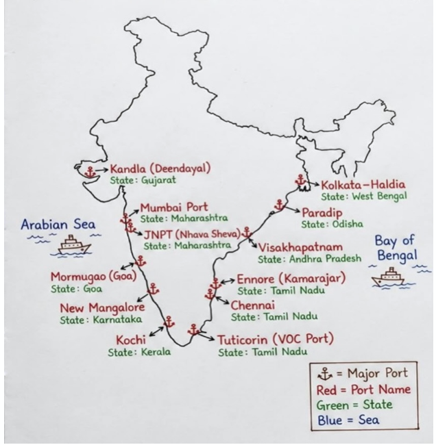
INDIA’S MARITIME MOMENTUM : PORTS DRIVING
Why in news : India’s major ports handled a record 915.17 million tonnes of cargo in the fiscal year 2025–26, surpassing a government target and marking a 7.06% increase from a year earlier.
About :
The cargo throughput exceeded the annual target of 904 million tonnes, reflecting improved operational efficiency, capacity expansion and stronger trade activity, the ministry said in a statement.
The performance comes as India pushes to modernise port infrastructure and strengthen logistics networks under its long-term Maritime Amrit Kaal Vision 2047, aimed at positioning the country as a global maritime hub.
How Rising Port Reflects India’s Maritime Momentum
1. Ports as Growth Poles (Perroux’s Growth Pole Theory)
- Major ports act as nodal points of economic activity, attracting industries like petrochemicals, logistics, SEZs.
- Spillover effects → development of port-based industrial regions (e.g., Gujarat coast).
- 👉 Example: Jamnagar refinery cluster linked to port infrastructure.
2. Spatial Integration & Reduction of Regional Disparities
- Ports enhance core–periphery linkages by connecting hinterlands to global markets.
- Inland regions (e.g., central India) gain export access via multimodal corridors.
- 👉 Aligns with balanced regional development in geography.
3. Strengthening Hinterland Connectivity (Ullman’s Spatial Interaction Model)
- Ports increase:
- Complementarity (export-import demand)
- Transferability (reduced transport cost via corridors)
- Development of Dedicated Freight Corridors, inland waterways improves flow.
- 👉 Example: Coal, iron ore movement from hinterland to ports.
4. Blue Economy Expansion
- Ports act as anchors for:
- Fisheries
- Offshore energy
- Shipbuilding
- Encourages sustainable ocean resource utilization
- 👉 Aligns with resource geography
5. Logistics Efficiency & Time-Space Convergence
- Faster cargo handling reduces:
- Transport time
- Trade costs
- Leads to time-space compression (David Harvey concept)
- 👉 Improves competitiveness in global markets
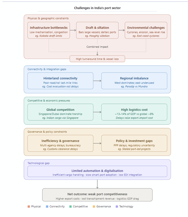
Government Initiatives for Port Development in India
1. SagarmalaProgramme
- Flagship initiative for port-led development
- Focus: Port modernization, connectivity, coastal economic zones (CEZs)
- Outcome: Reduced logistics cost, improved cargo handling capacity.
2. Maritime India Vision 2030
- Long-term roadmap for port capacity expansion and modernization
- Focus on smart ports, privatization, and global competitiveness
- Outcome: Enhancing India’s position in global maritime trade
3. Major Port Authorities Act 2021
- Grants autonomy to major ports
- Encourages PPP and private investment
- Outcome: Improved efficiency and decision-making
4. Green Port Initiative
- Promotes eco-friendly port operations (renewable energy, waste management)
- Outcome: Sustainable maritime development
Where to use ?
Paper II ( Geography Optional ) : Trade and Transport , Ports development
WHY IS IT RAINING IN MARCH ?
Why in news : IMD data shows that in the last seven years — between 2020 and 2026 — this March was the third wettest.
About :
March 2026 presented a climatic paradox—initially marked by record-breaking heat (above 35°C in early March), followed by significant rainfall events, making it one of the wettest March months in recent years (9.4 mm average rainfall).
- While appearing anomalous, experts suggest such variability falls within the ambit of pre-monsoon transitional dynamics.
Synoptic Mechanisms Behind the Rainfall
a) Western Disturbances (Primary Driver)
- Originating in the Mediterranean region, these systems move eastward.
- On reaching the Himalayas, they trigger rainfall in plains and snowfall in higher altitudes.
- March 2026 saw an intense western disturbance, enhancing precipitation.

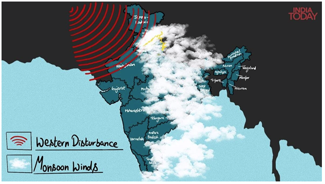
b) Induced Cyclonic Circulation
A low-pressure system formed over Haryana, intensifying atmospheric instability.
This led to the formation of a trough (elongated low-pressure zone):
- Facilitates vertical uplift of air
- Promotes cloud formation and precipitation
c) Moisture Incursion from Arabian Sea
- Moisture-laden winds enhanced humidity levels
- Increased precipitation intensity when combined with dynamic systems
Spatial Distribution of Rainfall
- Maximum impact observed in:
- North India (Delhi, Haryana, Punjab)
- Central India
- Eastward movement of systems extended rainfall to:
- Uttar Pradesh → Bihar → Jharkhand → West Bengal → Odisha
Reflects west-to-east propagation of mid-latitude systems, a key concept in climatology.
Temporal Context: Is March 2026 Truly Exceptional?
- March 2026 rainfall: 9.4 mm (below normal 12.6 mm but highest in 3 years)
- Comparative trend:
- 2020: 109.6 mm (extreme anomaly)
- 2023: 53.2 mm (above normal)
- 2021–22: Dry phase
👉 Indicates high inter-annual variability, not necessarily a long-term anomaly.
Role of Atmospheric Interaction
The rainfall event was not due to a single factor but a synergistic interaction of systems:
- Western disturbance → Provides instability
- Cyclonic circulation → Enhances uplift
- Moisture supply → Increases precipitation
👉 This reflects the concept of “multiple causation in climatology”, where weather events are outcomes of interacting atmospheric processes.
Impact on Temperature Regime
- Rainfall + cloud cover + Himalayan snowfall:
- Prevented sharp temperature rise
- Created a temporary cooling effect
👉 Demonstrates inverse relationship between cloud cover and surface temperature.
Conclusion: Variability within Normalcy
March 2026 rainfall illustrates that short-term climatic fluctuations do not always indicate abnormality. Instead, they reflect the complex interplay of atmospheric systems during seasonal transitions.
- The event underscores the need to interpret weather through a scientific-geographical lens, rather than perception-driven narratives.
Source : https://theprint.in/environment/why-raining-march/2884877/
Where to use :
Paper II ( Geography Optional ) : Indian Monsoon
“Jumpstart” Approach
“Jumpstart” Approach: The “Jumpstart” approach refers to initiating rapid development in a lagging sector or region by injecting targeted investments, policy support, or technology at the initial stage. It acts like giving an economy or project an early push to overcome inertia. For example, government subsidies for renewable energy help “jumpstart” adoption, after which market forces sustain growth. It is often used in regional planning and innovation ecosystems.
Smog-eating” photocatalytic coatings
Smog-eating” photocatalytic coatings: These are special coatings containing materials like titanium dioxide (TiO₂) that break down air pollutants using sunlight. When exposed to UV rays, they trigger chemical reactions that convert harmful gases like nitrogen oxides into less harmful substances. Applied on buildings or roads, they help reduce urban air pollution. However, their effectiveness depends on sunlight availability, surface area, and pollution concentration.
Epeirogeny
Epeirogeny: Epeirogeny refers to large-scale, slow vertical movements of the Earth’s crust affecting continents without causing major folding or faulting. It results in uplift (raising land) or subsidence (sinking). Unlike mountain-building (orogeny), it is gentle and widespread. Examples include the uplift of the Peninsular Plateau of India. It plays a key role in shaping drainage patterns, coastlines, and long-term geological evolution.
Lapse Rate
Lapse Rate: Lapse rate is the rate at which temperature decreases with an increase in altitude in the atmosphere. The normal (environmental) lapse rate is about 6.5°C per 1000 meters. It influences weather, cloud formation, and stability of the atmosphere. Variations like dry and moist adiabatic lapse rates are important in meteorology, especially for understanding convection, rainfall, and storm development.
Benthic Boundary Layer (BBL)
Benthic Boundary Layer (BBL): The Benthic Boundary Layer is the lowest layer of water just above the ocean floor where interactions between sediments and water occur. It is influenced by currents, turbulence, and biological activity. This zone plays a crucial role in nutrient exchange, sediment transport, and marine ecosystems. It also affects oxygen levels and carbon cycling, making it significant for oceanography and climate studies.
Role of Women in Fertility Control & Population Growth
Kerala demonstrates that women’s empowerment—through education, health access, and social agency—is the most decisive factor in reducing fertility and stabilizing population growth, even without high income levels.
Key Facts & Data (Validation)
- Total Fertility Rate (TFR): ~ 1.6–1.7 (below replacement level of 2.1).
- Female Literacy Rate: ~ 95%+ (one of the highest in India).
- Institutional Deliveries: > 99%.
- Contraceptive Prevalence Rate (CPR): ~ 70%+.
- Infant Mortality Rate (IMR): Among the lowest in India (~6–7 per 1000 live births).
👉 Indicates strong female awareness, health access, and decision-making power.
Role of Women in Fertility Control
1. Education → Awareness & Delayed Marriage
- Higher female literacy leads to better knowledge of contraception and reproductive health.
- Average age of marriage is higher → reduces reproductive span.
2. Health Access & Maternal Care
- Strong primary healthcare network ensures safe childbirth and family planning services.
- Women actively use modern contraceptive methods.
3. Economic Participation & Autonomy
- Programs like Kudumbashree (women SHGs) enhance financial independence.
- Economic agency → women prefer smaller families for better quality of life.
4. Social Status & Decision-Making
- Greater gender equality enables women to participate in family size decisions.
- Decline of patriarchal norms compared to many other regions.
Where to use ?
Paper I & II ( Geography Optional ) : Population & Cultural Settings
Places in News - 10 April 2026
1. Kalpakkam
Why in news : Recently, the indigenously developed Prototype Fast Breeder Reactor (PFBR) at Kalpakkam, Tamil Nadu, attained criticality, marking progress in India’s nuclear energy programme.
About :
- Kalpakkam is a coastal town in Tamil Nadu, located along the Coromandel Coast on the western margin of the Bay of Bengal.
- It lies about 70 km south of Chennai, making it part of the Chennai metropolitan influence zone.
- The region has sandy beaches and coastal dunes, typical of the east coast of India.
- Experiences a tropical maritime climate with high humidity and moderate temperature variation.
- Receives major rainfall from the Northeast Monsoon (Oct–Dec), unlike most of India.
- Hosts major nuclear facilities like Madras Atomic Power Station (MAPS) and Indira Gandhi Centre for Atomic Research (IGCAR), making it a key node in India’s nuclear energy programme.
2. Amravati
Why in news : The Lok Sabha has passed the Andhra Pradesh Reorganisation (Amendment) Bill, 2026, officially designating Amaravati as the sole and permanent capital of Andhra Pradesh, insulating the city's status from future political fluctuations.
About :
- Amaravati is located in the central part of Andhra Pradesh, on the southern bank of the Krishna River.
- It lies between major urban centres—Vijayawada and Guntur—forming part of a growing urban corridor.
- Situated in the Krishna River floodplain, characterized by flat, fertile alluvial land.
- The terrain supports intensive agriculture but is also prone to flooding during high river discharge.
- Experiences a tropical humid climate with hot summers and moderate winters.
- Receives rainfall from both the Southwest and Northeast monsoons, enhancing agricultural productivity.
3. Tughlakabad
Why in news : The Delhi High Court criticised the Archaeological Survey of India (ASI) for delays in conducting a court-ordered survey of encroachments at Tughlakabad Fort.
About :
- Tughlaqabad Fort is situated in southeast Delhi, along the Delhi–Faridabad corridor.
- It lies on the Delhi Ridge, an extension of the ancient Aravalli Range, giving it strategic elevation.
- Built on a rocky, elevated terrain, providing natural defence advantages.
- The surrounding landscape is semi-arid with sparse vegetation, typical of the ridge region.
- Experiences a semi-arid climate with hot summers, cool winters, and moderate monsoon rainfall.
- Water scarcity historically influenced settlement patterns here.
- Founded by Ghiyas-ud-din Tughlaq as a fortified city for defence against invasions.
- Its location on elevated ground reflects the principle of “site advantage” in urban geography.
4. Zojiilla Pass :
Why in news : Zojila avalanche kills seven, sparks jurisdiction row
About :
- Zoji La is a high mountain pass in the Great Himalayas, connecting Kashmir Valley with Ladakh.
- It lies on the strategic Srinagar–Leh Highway (NH-1), acting as a crucial gateway to Ladakh.
- Located at an altitude of about 3,528 meters, characterized by rugged terrain, steep slopes, and glacial landforms.
- Marks a transition from the lush Kashmir Valley to the cold desert of Ladakh.
- Experiences extreme cold conditions, heavy snowfall, and frequent avalanches.
- Remains closed during winters, affecting connectivity.
5. Hope Island
Why in news : Satellite launching facility will come up on Hope Island in the Kakinada Bay, says Andhra Pradesh Chief Minister Chandrababu Naidu
About :
- Hope Island is located off the coast of Kakinada in the Bay of Bengal.
- It lies at the mouth of the Godavari River delta, forming part of a dynamic coastal system.
- It is a sand spit / barrier island formed by deposition of sediments carried by the Godavari River.
- Acts as a natural barrier separating the sea from the Kakinada Bay (lagoon-like environment).
- Protects Kakinada Port from direct wave action and storm surges.
- Supports mangroves, fisheries, and coastal biodiversity, making it ecologically significant.

Fortnightly KOSMOS MCQs Practice - 10th April 2026
Q1. Which of the following animals is NOT a cephalopod?
(a) Octopus
(b) Squid
(c) Snail
(d) Cuttlefish
Q2. With reference to the Plastic Waste Management (Amendment) Rules, 2026, consider the following statements:
1. The rules introduce mandatory year-on-year targets for the use of recycled plastic in packaging, reaching up to 60% for rigid plastics by 2028–29.
2. For the first time, "Sellers" of raw materials like resins and pellets are brought under the regulatory framework of the rules.
3. Registered Environment Auditors are now authorised to verify EPR compliance as an alternative to designated government agencies.
How many of the statements given above are correct?
(a) Only one
(b) Only two
(c) All three
(d) None
Q3. Consider the following pairs regarding Heat Wave Alerts and their meanings:
|
Alert Colour |
Severity / Action |
|
1. Yellow Alert |
Heat wave conditions at isolated pockets for 2 days |
|
2. Orange Alert |
Severe heat wave for more than 2 days |
|
3. Red Alert |
Total number of heat wave days exceeds 6 days |
How many of the pairs given above are correctly matched?
(a) Only one pair
(b) Only two pairs
(c) All three pairs
(d) None of the pairs
Q4. With reference to "Microplastics" as defined under the Plastic Waste Management (Amendment) Rules, 2024, consider the following statements:
1. They are defined as synthetic solid plastic particles that are soluble in water.
2. For biodegradable plastics to be certified in India, they must be proven to leave zero microplastics behind.
3. The upper size limit for a particle to be legally classified as a microplastic in India is 5 millimetres.
Which of the statements given above is/are correct?
(a) 1 and 2 only
(b) 2 only
(c) 2 and 3 only
(d) 1, 2, and 3
Q5. With reference to "Earth Hour," consider the following statements:
1. It is a global annual event organized by the United Nations Environment Programme (UNEP).
2. The event is typically held on the last Saturday of March by switching off non-essential lights for one hour.
3. Earth Hour 2026 marked the 20th anniversary of the global campaign.
Which of the statements given above are correct?
(a) 1 and 2 only
(b) 2 and 3 only
(c) 1 and 3 only
(d) 1, 2, and 3
Q6. Consider the following countries:
1. Yemen
2. Ethiopia
3. Djibouti
4. Eritrea
5. Somalia
The Bab-el-Mandeb Strait is bordered by which of the countries mentioned above?
(a) 1, 2, and 3 only
(b) 1, 3, and 4 only
(c) 1, 3, and 5 only
(d) 1, 2, 3, 4, and 5
Q7. Consider the following pairs of migratory birds and their IUCN Red List status:
|
Bird Species |
IUCN Status |
|
1. Hudsonian Godwit |
Least Concern |
|
2. Great Indian Bustard |
Critically Endangered |
|
3. Bar-tailed Godwit |
Near Threatened |
How many of the above pairs are correctly matched?
(a) Only one pair
(b) Only two pairs
(c) All three pairs
(d) None of the pairs
Q8. With reference to the Convention on the Conservation of Migratory Species (CMS), consider the following statements:
1. It is the only global convention specializing in the conservation of migratory species, their habitats, and their migration routes.
2. Appendix I of the Convention lists migratory species that are in danger of extinction throughout all or a significant portion of their range.
3. India has been a party to the CMS since its inception in 1979.
Which of the statements given above is/are correct?
(a) 1 and 2 only
(b) 2 and 3 only
(c) 1 only
(d) 1, 2, and 3
Q9. Consider the following pairs of geographical features in Lebanon:
1. Beqaa Valley: A fertile plateau situated between the Lebanon and Anti-Lebanon mountains.
2. Lake Qaraoun: An artificial reservoir formed by a dam on the Litani River.
3. Blue Line: The international boundary demarcated by the UN following the 1967 war.
How many of the pairs given above are correctly matched?
(a) Only one pair
(b) Only two pairs
(c) All three pairs
(d) None of the pairs
Q10. Consider the following pairs of locations in Iran and their significance:
|
Location |
Key Significance |
|
1. Kharg Island |
Primary terminal for Iran's crude oil exports |
|
2. Natanz |
Key site for Iran's uranium enrichment program |
|
3. Lake Urmia |
A major endorheic salt lake facing ecological desiccation |
How many of the pairs given above are incorrectly matched?
(a) Only one pair
(b) Only two pairs
(c) All three pairs
(d) None of the pairs
Share the article
Get Latest Updates on Offers, Event dates, and free Mentorship sessions.

Get in touch with our Expert Academic Counsellors 👋
FAQs
Geography Current Affairs focuses on the contemporary issues, events, and developments in the field of geography. It covers recent geographical phenomena, environmental changes, geopolitical shifts, and related news. This differs from regular geography studies which may focus more on foundational concepts, historical contexts, and theoretical frameworks.
Updates are provided regularly to ensure that subscribers stay informed about the latest developments in geography. Typically, updates are provided on a fortnightly basis, depending on the frequency of significant events and changes in the field.
Absolutely. Geography Current Affairs serves as a valuable resource not only for Geography optional but also for GS papers, especially GS Paper 1 (covering Indian Heritage and Culture, History, and Geography of the World and Society) and GS Paper 3 (covering Technology, Economic Development, Biodiversity, Environment, Security, and Disaster Management). It aids in building a holistic understanding of various topics and strengthens answer-writing skills by incorporating contemporary examples and perspectives.
Geography Current Affairs holds immense importance for UPSC preparation, particularly for aspirants opting for Geography optional. It helps candidates stay updated with the latest developments, geographical phenomena, environmental issues, and geopolitical shifts worldwide, aligning them with the dynamic nature of the subject as tested in the UPSC examinations.