
10 Apr to 24 Apr, 2025
CLIMATE SHOCKS AND ECONOMIC LOSSES
Why in news : Climate shocks could cause annual economic losses of at least 6% in a third of Asia-Pacific countries , according to UN report .
About :
Climate change can be a natural process where temperature, rainfall, wind and other elements vary over decades or more. In millions of years, our world has been warmer and colder than it is now.
Incidences of Climate shocks
- Temperature Rise : Based on the global average temperature for the most recent 10-year period (2014- 2023), the Earth is now about 1.2°C warmer than it was in the pre-industrial era (1850- 1900). 2023 was the warmest year on record, with the global average near-surface temperature 1.45°C above the pre-industrial baseline. The period 2011-2020 was the warmest decade on record for both land and ocean.
- Rising Sea Levels: Global sea levels rose 8–9 inches (21–24 cm) since 1880, accelerating to 3.6 mm/year (2006–2015)—2.5× faster than 20th-century rates
- Rising Severe Storms & Cyclones : Warmer oceans provide energy for storms; altered wind patterns.461 tornadoes by April 2025, including 59 EF-2+ twisters; EF-3 tornadoes in Tennessee (160 mph winds) killed 5.
- Jet Stream Disruption : Arctic warming reduces temperature gradients, weakening polar vortex winds . Early polar vortex collapse shifted winds to easterly, triggering cold snaps in the U.S. and Europe.Increased "waviness" in jet streams links to prolonged droughts/heatwaves (e.g., 2021 Pacific Northwest heat dome)
.png")
Key drivers of Climate Shocks
- Greenhouse Gas Emissions : : Accumulation of CO₂, CH₄, N₂O, and other GHGs causes the earth’s atmosphere to trap more heat, amplifying climate anomalies.
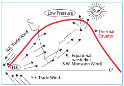
- Ocean-Atmosphere Interactions : Events like El Niño, La Niña, and Indian Ocean Dipole change rainfall patterns, intensify droughts/floods, and disrupt monsoons. The 2015 El Niño led to severe droughts in southern Africa and Indonesia while flooding parts of South America.
- Deforestation and Land Use Changes : Clearing forests reduces carbon sequestration, alters evapotranspiration cycles, and changes local albedo, creating regional feedback loops. The Amazon’s deforestation is contributing to decreased rainfall in southern Brazil, heightening drought frequency.
- Aerosol and Black Carbon Emissions : While aerosols can cool the atmosphere by reflecting sunlight, black carbon absorbs heat and settles on snow, accelerating melting. Black carbon from Indo-Gangetic Plain has been linked to rapid glacial retreat in the Himalayas.
Climate Change Threat to Macroeconomic Stability in Asia-Pacific
- Average Annual Loss (AAL) : UNESCAP ( United Nations Economic Social Council For Asia Pacific ) employs the Average Annual Loss (AAL) metric to estimate yearly economic damages from disasters. This calculation integrates factors such as hazard frequency, severity, exposure levels, and societal vulnerability. Among the 30 Asia-Pacific nations studied, AAL constitutes an average of 4.8% of GDP. However, countries like Cambodia (nearly 11%), and Fiji, Myanmar, and Pakistan (at least 7%) face disproportionately higher economic risks.
- Vulnerability of Developing Economies : Out of the 30 countries assessed, 11 developing economies—namely Afghanistan, Cambodia, Iran, Kazakhstan, Laos, Mongolia, Myanmar, Nepal, Tajikistan, Uzbekistan, and Vietnam—exhibit acute vulnerability to climate-related macroeconomic shocks. Rapid urban expansion and underdeveloped infrastructure, especially in coastal zones, exacerbate climate risk and contribute to escalating economic losses. Despite driving 60% of global economic growth in 2024, many of these nations lack the adaptive capacity to effectively withstand climate-induced disruptions.
- Sectoral Exposure : The agriculture sector is particularly exposed, with rice yields expected to decline by up to 14% by 2050, posing serious threats to food security and farmer livelihoods in countries such as India. Additionally, economies heavily dependent on fossil fuels—including Indonesia, India, and China—are at risk of substantial economic disruption due to the ongoing shift toward renewable energy, potentially leading to widespread job losses and reduced state revenues. Meanwhile, the fisheries sector is projected to suffer significantly, with fish stocks in tropical regions anticipated to decline by up to 30% by 2050, undermining food systems and coastal economies.
.png")
Major Climate Change Impacts on India’s Economy
- India’s Economic Impact: According to the Asian Development Bank (ADB), climate change could reduce India’s GDP by 24.7% by 2070, severely affecting economic growth.
- India is experiencing rising temperatures, with more frequent and intense heatwaves expected in the coming years. The World Bank (2022) estimates that by 2030, India could lose 34 million jobs out of a projected 80 million global job losses caused by heat stress reducing productivity. Furthermore, 4.5% of India’s GDP may be at risk due to reduced working hours in extreme heat and humidity.
- Agricultural Decline: Increasing temperatures and unpredictable rainfall are lowering crop yields, particularly for rice and wheat. The World Bank warns that if global temperatures rise by 2°C by the 2050s, India might have to import over twice as much food grain compared to a no-climate-change scenario.
- Rising Sea Levels: With a 7,500 km coastline, India is highly vulnerable to sea-level rise, with 32% of its shores already eroded between 1990 and 2018.
Major coastal cities like Mumbai and Kolkata face growing flood threats, while the Sundarbans could lose up to 80% of its area by 2100. - Extreme Weather Events: As per Germanwatch’s Climate Risk Index (1993–2023), India ranks 6th among the most climate-vulnerable nations.
Over the past three decades, India has suffered more than 400 extreme weather events, leading to economic losses of USD 180 billion and over 80,000 deaths.
Way Forward to Curb Climate-Driven Economic Losses
- Embrace Circular Economy: Asia-Pacific nations should adopt circular economy models, where waste from one sector becomes a resource for another, reducing emissions and optimizing resource efficiency. India can lead by developing Zero Waste Cities through Waste-to-Wealth programs, minimizing landfill dependency and maximizing material reuse.
- Foster Green Innovation: Support climate-tech startups working on breakthrough solutions like carbon capture, renewable energy storage, and clean production technologies.
India can accelerate green innovation by leveraging initiatives like the Atal Innovation Mission and Startup India, while securing additional funding from the Green Climate Fund (GCF) to scale sustainable solutions. - Climate-Resilient Infrastructure: Invest in flood-resistant urban planning and heat-proof construction to safeguard cities against extreme weather.
India should integrate climate adaptation into the Smart Cities Mission and National Action Plan on Climate Change (NAPCC).
Creating climate-smart Special Economic Zones (SEZs) with sustainable infrastructure—similar to the UAE’s Masdar City—can attract eco-friendly industries and boost green growth. - Green Taxonomy: India should establish a clear green classification system to direct investments toward sustainable sectors, aligning it with the NAPCC to enhance transparency in green financing.
- Global Climate Funds: Financial mechanisms like the Loss and Damage Fund (LDF) are vital for helping Asia-Pacific countries build climate resilience, adopt sustainable agriculture, and transition to renewables.
Expanding the LDF’s reach and funding is essential for effective climate adaptation across vulnerable regions.
Source :
Where to use :
Paper I ( Geography optional ) : Man response to Climate Change
Paper III ( General Studies ) : Global warming and Climate Change
ATMOSPHERIC RIVER
Why in news : In April 2025, a large part of the US experienced heavy rain, strong winds, and severe thunderstorms due to a meteorological phenomenon known as an Atmospheric River (AR).
About :
- An atmospheric river (AR) is commonly referred to as a "river in the sky" due to its long, narrow band of concentrated moisture-laden air that transports vast quantities of water vapor from the tropical oceans toward landmasses. Unlike physical rivers, atmospheric rivers are invisible to the naked eye, yet they can deliver significant precipitation when they make landfall.
- A notable example is the "Pineapple Express", a specific type of atmospheric river that channels warm, moist air from the tropical Pacific near Hawaii to the U.S. West Coast, especially California, often resulting in intense rainfall and flooding events.
Characteristics
Shape & Size : According to the National Oceanic and Atmospheric Administration (NOAA), atmospheric rivers (ARs) can extend up to 1,600 kilometers in length and span 400 to 600 kilometers in width, forming long and narrow corridors of concentrated atmospheric moisture.
Moisture Content: These systems carry immense amounts of water vapor, often comparable to the average discharge at the mouth of the Mississippi River. The most intense ARs can transport up to 15 times more moisture than that river’s flow.
Categories
Atmospheric rivers are classified into five categories, depending on their intensity and impacts:
- Category 1 (Weak): Largely beneficial; contributes to soil moisture and aids in recovery from drought conditions.
- Category 2 (Moderate): Generally helpful in replenishing water reservoirs post-drought, though persistent rainfall may lead to localized flooding and mudslides.
- Category 3 (Strong): A mix of advantages and hazards; while it supports reservoir recharge, it also raises flood risks due to heavy rainfall in already saturated regions.
- Category 4 (Extreme): Mainly hazardous, though still useful for mitigating droughts. These events can push rivers to flood stage, triggering serious flooding.
- Category 5 (Exceptional): Predominantly destructive, resulting in severe flooding, landslides, and significant economic damage, sometimes amounting to billions of dollars in losses.
.jpeg")
Formation
- Atmospheric rivers originate over warm tropical or subtropical oceans (such as the central Pacific or parts of the Indian Ocean), where high evaporation rates saturate the atmosphere with moisture.
- This moisture is then transported by low-level jet streams—fast-moving winds in the lower atmosphere—from the tropics toward the mid-latitudes.
- When this moist air encounters topographic features like mountain ranges or frontal systems, it is lifted upward, cooling and condensing into intense rainfall or snowfall.
Significance
- Atmospheric rivers play a vital role in water resource management, as they significantly enhance snowpack accumulation in mountainous regions, which is crucial for long-term water availability.
- They are responsible for more than 90% of poleward water vapor transport in the mid-latitudes and can lead to extreme precipitation events when they make landfall, especially in vulnerable regions.
AR in India
- Between 1951 and 2020, India witnessed around 596 significant atmospheric river events, with over 95% occurring during the southwest monsoon season (June–September).
- Roughly 70% of major flood events between 1985 and 2020—including the 2013 Uttarakhand floods, 2018 Kerala floods, and 2007 South Asian floods—were closely associated with atmospheric rivers.
- In recent years, both the frequency and intensity of ARs have shown an upward trend, especially in the Indo-Gangetic Plains and peninsular India, leading to widespread damage and loss of life.
Impact of Climate Change on AR
- Global warming is amplifying the effects of atmospheric rivers. As temperatures rise, the atmosphere's moisture-holding capacity increases by approximately 7% for every 1°C rise, resulting in more intense and moisture-laden ARs.
- In the future, atmospheric rivers are projected to become longer, broader, and more powerful, with extreme AR events potentially doubling—thereby escalating flood risks in already vulnerable areas.
.jpeg")
https://indianexpress.com/article/explained/atmospheric-river-9940715/
Where to use :
Paper I ( Geography Optional ) : Climatology
THAR DESERT GREENING
Why in news : According to a new study, the Thar Desert in India has experienced a 38% annual increase in greening over the past two decades, driven by significant monsoon rainfall and agricultural expansion.
About :
The Thar Desert, one of the world’s most densely populated deserts, has experienced a remarkable 38% annual increase in greening over the past two decades. This transformation is driven by a combination of climate change-induced rainfall variability and human activities, including agricultural expansion and groundwater extraction.
.png")
1. Increased Monsoon Rainfall
The Thar Desert has defied global aridification trends, witnessing a 64% rise in preAcipitation between 2001 and 2023. Rainfall increased at a rate of 4.4 mm/year, particularly in the northwestern regions during the summer monsoon.
- Among the 14 major global deserts, only four (Thar, Arabian, Negev, and Eastern Gobi) saw significant rainfall increases, while the Namib Desert experienced a decline.
- This "opposing effect of climate change"—where some deserts get wetter—has directly contributed to vegetation growth.
2. Agricultural Expansion and Groundwater Use
Human interventions, particularly irrigation and farming, have played a crucial role in greening the Thar Desert.
- Cropland expanded by 74% and irrigated areas by 24% between 1980 and 2015.
- Groundwater contributes 55% of the greening annually, while rainfall accounts for 45%.
- Monsoon season: Rainfall drives 66% of vegetation growth.
- Non-monsoon season: Groundwater sustains 67% of greening.
However, excessive groundwater extraction has led to depletion, especially in north-central regions where well levels are declining.
3. Urbanization and Population Growth
The Thar Desert has the highest population growth among global deserts, leading to rapid urbanization.
- Urban areas expanded by 50% to 800% between 1985 and 2020.
- The Indira Gandhi Canal has enhanced water availability, supporting agriculture and settlements.
4. Future Challenges
While projections suggest 20–50% more rainfall in the coming decades, challenges remain:
- Heat extremes may increase energy and irrigation demands.
- Groundwater depletion threatens long-term sustainability.
Conclusion
The greening of the Thar Desert is a complex interplay of climate change (increased rainfall) and human actions (agriculture, urbanization, and groundwater use). While beneficial in the short term, unsustainable water use and rising temperatures could pose future risks to this fragile ecosystem.
Source :
Brood Parasitism
Brood Parasitism : Brood parasitism is an evolutionary strategy where certain animals, particularly birds like cuckoos and cowbirds, lay their eggs in the nests of other species. The host parents unknowingly raise the parasitic offspring, often at the expense of their own young. Some parasitic chicks even eject the host’s eggs or outcompete them for food. This behavior saves energy for the parasite but can harm host populations. It has led to an evolutionary arms race, with hosts developing defenses like egg recognition, while parasites evolve mimicry to deceive them.
Blue category industries
Blue category industries : These are industries classified as having minimal environmental impact, requiring little to no pollution control. Examples include IT, consulting, and service-based sectors that do not involve heavy manufacturing or hazardous waste. Unlike Red (highly polluting, e.g., chemicals) or Green (moderate impact, e.g., food processing) categories, Blue industries typically operate with low emissions and energy use. Governments encourage such businesses for sustainable growth, as they align with eco-friendly policies and reduce industrial strain on ecosystems.
ARRIBADA - 24TH APRIL 2025
Arribada : Arribada (Spanish for "arrival") refers to the synchronized mass nesting of sea turtles, particularly Olive Ridleys, where thousands of females emerge on beaches simultaneously to lay eggs. This rare phenomenon overwhelms predators, ensuring higher survival rates for hatchlings. Key arribada sites include Odisha (India) and Costa Rica. However, threats like poaching, habitat loss, and climate change endanger this spectacle. Conservation efforts focus on protecting nesting beaches to sustain this unique reproductive strategy.
Sick building syndrome
Sick building syndrome : SBS describes a range of health symptoms—headaches, dizziness, respiratory issues—linked to prolonged exposure to poorly ventilated or contaminated indoor environments. Causes include volatile organic compounds (VOCs) from paints, mold, inadequate HVAC systems, or trapped pollutants. Office buildings with sealed windows are common hotspots. Mitigation involves better air filtration, natural ventilation, and low-emission materials. Long-term exposure can lead to chronic illnesses, making SBS a critical occupational health concern.
Atmospheric river - 24TH APRIL 2025
Atmospheric river : These are long, narrow corridors of concentrated moisture in the atmosphere, often stretching thousands of kilometers. When they make landfall, they release intense rainfall or snow, causing floods or heavy snowfall. The "Pineapple Express"—a Pacific atmospheric river—is notorious for drenching California. While vital for water supply, these systems can also trigger disasters. Climate change may intensify their frequency and severity, impacting global weather patterns and water management strategies.
KHAM RIVER RESTORATION IN AURANGABAD , MAHARASHTRA
Kham River is a 65km long seasonal river & tributary of the Godavari River. Chatrapati Sambhaji Nagar (Aurangabad City) is situated on the bank of this river. It divides the city into two parts.
Kham River Restoration Initiative was launched in 2021. This Mission adopts a public-private-civil society partnership model involving the Chhatrapati Sambhajinagar Municipal Corporation, Varroc Industries, Aurangabad Cantonment Board, startup EcoSattva Environmental Solutions, many NGOs & citizens of the city
Key interventions
- Waste Management: Removal of over 100,000 square meters of solid waste and diversion of 5 million litres of sewage daily.
- Ecological Restoration: Stabilization of riverbanks, dredging, and the creation of wetlands and riparian zones.
- Green Infrastructure: Establishment of a 5 km EcoPark with recreational spaces and planting of more than one lakh native saplings.
- Technology Integration: Use of the BOTRAM app for real-time monitoring and data-driven decision-making.
- Community Engagement: Active participation of over one million residents of the city through educational campaigns, clean-up drives, and cultural programs like the “Kham Song.”etc.
.jpeg")
Where to use :
Paper 1 ( Geography Optional ) : Environment and Ecology
Paper III ( General Studies ) : Ecosystem Conservation
Source : https://www.millenniumpost.in/opinion/reviving-indias-rivers-597580
Places in News - 24 April 2025
1. Ratlam
Why in news : An ammonia gas leak at an ice factory in Ratlam, Madhya Pradesh, triggered panic among residents.
About :
- Ratlam is a city in the northwestern part of the Malwa region in Madhya Pradesh state of India.
- Ratlam, like most of Madhya Pradesh, has tropical savanna climate (Köppen climate classification Aw) bordering humid subtropical climate (Cwa) zone. Three distinct seasons are observed: summer, monsoon and winter.
- Ratlam is connected to Indore and Neemuch via National Highway 79. This four-lane highway runs from Indore to Chittorgarh to join the Golden Quadrilateral.
- Approx : Indore
2. Siachen
Why in news : Siachen Day (13th April) commemorates Operation Meghdoot, which marked India’s successful military control of the Siachen Glacier in 1984.
About :
- The Siachen Glacier is a glacier located in the eastern Karakoram range in the Himalayas.
- The Siachen Glacier lies immediately south of the great drainage divide that separates the Eurasian Plate from the Indian subcontinent in the extensively glaciated portion of the Karakoram sometimes called the "Third Pole".
- The glacier's melting waters are the main source of the Nubra River in the Indian region of Ladakh, which drains into the Shyok River.
- Approx : Ladakh
.jpeg")
3. Pamban Bridge
Why in news : The Prime Minister inaugurated India’s first vertical lift railway sea bridge, the new Pamban Bridge, enhancing connectivity between Rameswaram and mainland India.
About :
- Pamban Bridge was a railway bridge that connected the town of Rameswaram on Pamban Island with Mandapam in mainland India.
- The bridge was damaged during the 1964 Rameswaram cyclone.
- The Pamban railway bridge spans a 2.06 km (1.28 mi) wide strait between the Indian mainland and Pamban Island.
- Approx : Ramanathpuram
4. Agasthyamalai BR
Why in news : The Supreme Court has directed the Central Empowered Committee (CEC) to carry out a detailed survey of the Agasthyamalai landscape to identify any non-forestry activities and encroachments.
About :
- It is a biosphere reserve in India established in 2001, located in the southernmost end of the Western Ghats in Kerala and in Tamil Nadu.
- It encompasses the following wildlife sanctuaries: Shendurney Wildlife Sanctuary, Peppara Wildlife Sanctuary, Neyyar Wildlife Sanctuary, and Kalakkad Mundanthurai Tiger Reserve.
- In 2016, Agasthyamalai Biosphere Reserve became part of the UNESCO World Network of Biosphere Reserves.[
- Kanikkarans are the Original tribal Settlers in Agasthyamalai Biosphere Reserve.
- Approx : Kollam
5. Nathatop
Why in news : India has inaugurated the Himalayan High Altitude Atmospheric and Climate Research Centre at Nathatop, Jammu & Kashmir, marking a major milestone in global climate science.
About :
- Nathatop is a radar station and tourist spot located between Sanasar and Patnitop in the Udhampur district of Jammu and Kashmir, India.
- It is located on the Jammu-Srinagar National Highway 121 km from Jammu, on the way from Udhampur to Srinagar.
- Situated on a plateau in the Shivalik belt of the Himalayas, Nathatop sits at an altitude of 2,133 m (6,998 ft).
- The river Chenab flows in close proximity to this location.
- Approx : Udhampur
.jpeg")
Fortnightly KOSMOS MCQs Practice - 24th April 2025
Q1. Consider the following statements regarding Olive Ridley Turtles:
1. They are known for a unique phenomenon called Arribada, in which thousands of female turtles come ashore to nest simultaneously on the same beach.
2. Odisha’s Gahirmatha Marine Sanctuary is considered the world’s largest rookery for these sea turtles.
Which of the above statements is/are correct?
- 1 Only
- 2 Only
- Both 1 and 2
- Neither 1 nor 2
Q2. The Central Pollution Control Board (CPCB) has recently revised its industry classification system. Which of the following best describes the new "Blue Category" added to the system?
- It is created for industries providing essential environmental services like waste management and biomining.
- It is introduced to classify industries based on their potential for producing noise pollution.
- It categorizes industries involved in reducing water pollutants in lakes.
- It is designed to classify industries that focus on reducing air pollution.
Q3. Consider the following statements:
Statement–I: The mountainous terrain of the Kashmir Valley supports a wide range of habitats that promote the growth of diverse plant species.
Statement–II: The variation in altitude, from low-lying plains to high-altitude alpine meadows, enables the flourishing of distinct types of vegetation, contributing to the valley’s status as an ecological hotspot.
Which one of the following is correct in respect of the above statements?
- Both Statement-I and Statement-II are correct, and Statement-II is the correct explanation for Statement-I.
- Both Statement-I and Statement-II are correct, and Statement-II is not the correct explanation for Statement-I.
- Statement-I is correct, but Statement-II is incorrect.
- Statement-I is incorrect, but Statement-II is correct
Q4. Consider the following statements regarding the Himalayan High Altitude Atmospheric and Climate Research Centre:
1. It is situated at an elevation exceeding 3,000 meters in Himachal Pradesh.
2. It holds the distinction of being India’s first high-altitude climate research facility.
3. Its location is ideal for precise atmospheric observations due to clean air and low pollution levels.
Which of the statements given above is/are correct?
- 1 and 2 only
- 2 and 3 only
- 1 and 3 only
- 1, 2 and 3
Q5. Consider the following statements:
1. The Loss and Damage Fund (LDF) extends financial assistance to Asia-Pacific countries for building climate-resilient infrastructure and advancing renewable energy transitions.
2. India has instituted a legally binding Green Taxonomy that supports the objectives outlined in the National Action Plan on Climate Change (NAPCC).
3. Masdar City in the United Arab Emirates is recognized as a global model of a climate-resilient Special Economic Zone (SEZ).
How many of the above statements is/are correct?
- Only one
- Only two
- All three
- None
Q6. Consider the following statements regarding the Agasthyamalai Biosphere Reserve:
1. This area is part of the Western Ghats, extending through both Tamil Nadu and Karnataka.
2. It is known for the Neelakurinji flower, which blooms only once every 12 years.
3. The region is home to the Kani tribe.
Which of the statements given above is/are correct?
- 1 and 2 only
- 2 and 3 only
- 1 and 3 only
- 1, 2 and 3
Q7. Consider the following statements regarding the Thar Desert:
1. This arid landscape of undulating sand dunes spans portions of Rajasthan, Gujarat, Punjab and Haryana in India, continuing into Pakistan's Sindh and Punjab provinces.
2. Its boundaries are defined by: the Indus River plain (west), Punjab Plain (north/northeast), Aravalli Range (southeast), and Rann of Kachchh (south).
3. The desert contains one of the planet's most extensive deposits of Bituminous coal.
How many of the above statements is/are correct?
- Only one
- Only two
- All three
- None
Q8. Consider the following statements with reference to the project RE-HAB:
1. Its primary objective is to mitigate human-elephant conflicts.
2. The Khadi and Village Industries Commission (KVIC) is the implementing agency for this initiative.
3. It operates as a specialized component under the National Honey Mission.
How many of the statements given above is/are correct?
- Only One
- Only Two
- All Three
- None
Q9. Which of the following is true about the newly inaugurated Pamban Bridge in India?
- A road suspension bridge constructed for vehicular transport.
- Engineered to resist both cyclonic winds and earthquake forces.
- A single-track railway bridge featuring vertical lift mechanism.
- A link between India and Sri Lanka across the Gulf of Mannar.
Q10. Consider the following statements:
1. Formaldehyde is frequently present in domestic cleaning products and pest control chemicals.
2. Inhalation of asbestos fibers may cause severe pulmonary disorders.
3. Carbon monoxide, a colorless and odorless gas, is produced when fuels burn incompletely.
Which of the statements given above is/are correct?
- 1 and 2 only
- 2 and 3 only
- 1 and 3 only
- 1, 2 and 3
Share the article
Edukemy’s Current Affairs Quiz is published with multiple choice questions for UPSC exams
MCQ
Get Latest Updates on Offers, Event dates, and free Mentorship sessions.

Get in touch with our Expert Academic Counsellors 👋
FAQs
Geography Current Affairs focuses on the contemporary issues, events, and developments in the field of geography. It covers recent geographical phenomena, environmental changes, geopolitical shifts, and related news. This differs from regular geography studies which may focus more on foundational concepts, historical contexts, and theoretical frameworks.
Updates are provided regularly to ensure that subscribers stay informed about the latest developments in geography. Typically, updates are provided on a fortnightly basis, depending on the frequency of significant events and changes in the field.
Absolutely. Geography Current Affairs serves as a valuable resource not only for Geography optional but also for GS papers, especially GS Paper 1 (covering Indian Heritage and Culture, History, and Geography of the World and Society) and GS Paper 3 (covering Technology, Economic Development, Biodiversity, Environment, Security, and Disaster Management). It aids in building a holistic understanding of various topics and strengthens answer-writing skills by incorporating contemporary examples and perspectives.
Geography Current Affairs holds immense importance for UPSC preparation, particularly for aspirants opting for Geography optional. It helps candidates stay updated with the latest developments, geographical phenomena, environmental issues, and geopolitical shifts worldwide, aligning them with the dynamic nature of the subject as tested in the UPSC examinations.