
10 Apr to 24 Apr, 2026
CLIMATE SHOCKS AND ECONOMIC LOSSES - 24th April 2026
Why in news: Climate shocks could cause annual economic losses of at least 6% in a third of Asia-Pacific countries , according to UN report .
About:
Climate change can be a natural process where temperature, rainfall, wind and other elements vary over decades or more. In millions of years, our world has been warmer and colder than it is now.
Incidences of Climate shocks
- Temperature Rise : Based on the global average temperature for the most recent 10-year period (2014- 2023), the Earth is now about 1.2°C warmer than it was in the pre-industrial era (1850- 1900). 2023 was the warmest year on record, with the global average near-surface temperature 1.45°C above the pre-industrial baseline. The period 2011-2020 was the warmest decade on record for both land and ocean.
- Rising Sea Levels: Global sea levels rose 8–9 inches (21–24 cm) since 1880, accelerating to 3.6 mm/year (2006–2015)—2.5× faster than 20th-century rates.
- Rising Severe Storms & Cyclones : Warmer oceans provide energy for storms; altered wind patterns.461 tornadoes by April 2025, including 59 EF-2+ twisters; EF-3 tornadoes in Tennessee (160 mph winds) killed 5.
- Jet Stream Disruption : Arctic warming reduces temperature gradients, weakening polar vortex winds . Early polar vortex collapse shifted winds to easterly, triggering cold snaps in the U.S. and Europe.Increased "waviness" in jet streams links to prolonged droughts/heatwaves (e.g., 2021 Pacific Northwest heat dome)

Key drivers of Climate Shocks
- Greenhouse Gas Emissions: Accumulation of CO₂, CH₄, N₂O, and other GHGs causes the earth’s atmosphere to trap more heat, amplifying climate anomalies.
- Ocean-Atmosphere Interactions: Events like El Niño, La Niña, and Indian Ocean Dipole change rainfall patterns, intensify droughts/floods, and disrupt monsoons. The 2015 El Niño led to severe droughts in southern Africa and Indonesia while flooding parts of South America.
- Deforestation and Land Use Changes: Clearing forests reduces carbon sequestration, alters evapotranspiration cycles, and changes local albedo, creating regional feedback loops. The Amazon’s deforestation is contributing to decreased rainfall in southern Brazil, heightening drought frequency.
- Aerosol and Black Carbon Emissions: While aerosols can cool the atmosphere by reflecting sunlight, black carbon absorbs heat and settles on snow, accelerating melting. Black carbon from Indo-Gangetic Plain has been linked to rapid glacial retreat in the Himalayas.
Climate Change Threat to Macroeconomic Stability in Asia-Pacific
- Average Annual Loss (AAL) : UNESCAP ( United Nations Economic Social Council For Asia Pacific ) employs the Average Annual Loss (AAL) metric to estimate yearly economic damages from disasters. This calculation integrates factors such as hazard frequency, severity, exposure levels, and societal vulnerability. Among the 30 Asia-Pacific nations studied, AAL constitutes an average of 4.8% of GDP. However, countries like Cambodia (nearly 11%), and Fiji, Myanmar, and Pakistan (at least 7%) face disproportionately higher economic risks.
- Vulnerability of Developing Economies : Out of the 30 countries assessed, 11 developing economies—namely Afghanistan, Cambodia, Iran, Kazakhstan, Laos, Mongolia, Myanmar, Nepal, Tajikistan, Uzbekistan, and Vietnam—exhibit acute vulnerability to climate-related macroeconomic shocks. Rapid urban expansion and underdeveloped infrastructure, especially in coastal zones, exacerbate climate risk and contribute to escalating economic losses. Despite driving 60% of global economic growth in 2024, many of these nations lack the adaptive capacity to effectively withstand climate-induced disruptions.
- Sectoral Exposure : The agriculture sector is particularly exposed, with rice yields expected to decline by up to 14% by 2050, posing serious threats to food security and farmer livelihoods in countries such as India. Additionally, economies heavily dependent on fossil fuels—including Indonesia, India, and China—are at risk of substantial economic disruption due to the ongoing shift toward renewable energy, potentially leading to widespread job losses and reduced state revenues. Meanwhile, the fisheries sector is projected to suffer significantly, with fish stocks in tropical regions anticipated to decline by up to 30% by 2050, undermining food systems and coastal economies.

Major Climate Change Impacts on India’s Economy
- India’s Economic Impact: According to the Asian Development Bank (ADB), climate change could reduce India’s GDP by 24.7% by 2070, severely affecting economic growth.
- India is experiencing rising temperatures, with more frequent and intense heatwaves expected in the coming years. The World Bank (2022) estimates that by 2030, India could lose 34 million jobs out of a projected 80 million global job losses caused by heat stress reducing productivity. Furthermore, 4.5% of India’s GDP may be at risk due to reduced working hours in extreme heat and humidity.
- Agricultural Decline: Increasing temperatures and unpredictable rainfall are lowering crop yields, particularly for rice and wheat. The World Bank warns that if global temperatures rise by 2°C by the 2050s, India might have to import over twice as much food grain compared to a no-climate-change scenario.
- Rising Sea Levels: With a 7,500 km coastline, India is highly vulnerable to sea-level rise, with 32% of its shores already eroded between 1990 and 2018. Major coastal cities like Mumbai and Kolkata face growing flood threats, while the Sundarbans could lose up to 80% of its area by 2100.
- Extreme Weather Events: As per Germanwatch’s Climate Risk Index (1993–2023), India ranks 6th among the most climate-vulnerable nations. Over the past three decades, India has suffered more than 400 extreme weather events, leading to economic losses of USD 180 billion and over 80,000 deaths.
Way Forward to Curb Climate-Driven Economic Losses
- Embrace Circular Economy: Asia-Pacific nations should adopt circular economy models, where waste from one sector becomes a resource for another, reducing emissions and optimizing resource efficiency. India can lead by developing Zero Waste Cities through Waste-to-Wealth programs, minimizing landfill dependency and maximizing material reuse.
- Foster Green Innovation: Support climate-tech startups working on breakthrough solutions like carbon capture, renewable energy storage, and clean production technologies. India can accelerate green innovation by leveraging initiatives like the Atal Innovation Mission and Startup India, while securing additional funding from the Green Climate Fund (GCF) to scale sustainable solutions.
- Climate-Resilient Infrastructure: Invest in flood-resistant urban planning and heat-proof construction to safeguard cities against extreme weather. India should integrate climate adaptation into the Smart Cities Mission and National Action Plan on Climate Change (NAPCC). Creating climate-smart Special Economic Zones (SEZs) with sustainable infrastructure—similar to the UAE’s Masdar City—can attract eco-friendly industries and boost green growth.
- Green Taxonomy: India should establish a clear green classification system to direct investments toward sustainable sectors, aligning it with the NAPCC to enhance transparency in green financing.
- Global Climate Funds: Financial mechanisms like the Loss and Damage Fund (LDF) are vital for helping Asia-Pacific countries build climate resilience, adopt sustainable agriculture, and transition to renewables. Expanding the LDF’s reach and funding is essential for effective climate adaptation across vulnerable regions.
Source:
Where to use:
Paper I ( Geography optional ) : Man response to Climate Change
Paper III ( General Studies ) : Global warming and Climate Change
WATER CRISIS IN SOUTH INDIA - 24th April 2026
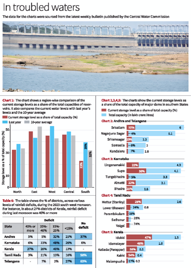
Why in news: The southern states of India, particularly Karnataka, Tamil Nadu, Andhra Pradesh, and Telangana, are facing a severe water crisis due to significantly low water levels in major reservoirs.
About:
- The Central Water Commission reports that the majority of significant reservoirs in Karnataka, Tamil Nadu, Andhra Pradesh, and Telangana are at or below 25% capacity.
- Key dams such as Tungabhadra in Karnataka and Nagarjuna Sagar, located on the border between Andhra Pradesh and Telangana, are filled to less than 5% of their total capacity.
- Similarly, the Mettur dam in Tamil Nadu and Srisailam on the border of Andhra Pradesh and Telangana are also experiencing depleted levels, with water storage under 30% of their full capacity.
Comparison of Water Levels Across Regions
- The southern region is currently facing significant water scarcity, with its reservoirs filled to merely 23% of their capacity—a figure substantially below both the previous year's levels and the ten-year average.
- In stark contrast, reservoirs in northern, central, western, and eastern India are maintaining water levels that align more closely with their ten-year historical averages.
Exception in Kerala:
- Kerala is an exception among the southern states, with the majority of its major dams reaching at least 50% capacity.
- Notably, reservoirs such as Idukki, Idamalayar, Kallada, and Kakki have maintained comparatively higher water levels.
What are the Reasons for the Water Crisis in South India?
- Impact of El Niño on Rainfall: The El Niño phenomenon, which involves the warming of sea surface temperatures in the Pacific Ocean, disrupts global weather patterns and often results in lower rainfall, thereby causing drought conditions and extended dry spells in the region.
- Monsoon and Post-Monsoon Rainfall Shortfalls: The region has faced significant water depletion in reservoirs due to insufficient rainfall during both the monsoon and the post-monsoon seasons. The monsoon's delayed start and lack of adequate rainfall at crucial times have worsened the situation. Notably, over 50% of the country experienced rainfall deficiency from October to December 2023.
- Elevated Temperatures and Increased Evaporation: Global warming has led to higher temperatures which, in turn, increase evaporation rates, accelerating the reduction of water levels in reservoirs and other bodies of water. These higher temperatures also intensify drought conditions and elevate water demand across agricultural, urban, and industrial sectors.
- Overuse of Groundwater: In areas where surface water is scarce, there has been an over-reliance on groundwater for irrigation. This is particularly evident in the cultivation of water-intensive crops like rice, sugarcane, and cotton in South India, leading to significant groundwater depletion.
- Contamination of Water Sources: Industrial effluents, untreated sewage, and the dumping of solid waste have polluted many water bodies, making the water unsuitable for use and diminishing the overall water supply. According to a study by the Environmental Management & Policy Research Institute (EMPRI), approximately 85% of water bodies in Bengaluru are affected by these pollutants.
- Challenges in Water Management and Distribution: The water scarcity crisis is exacerbated by inefficient water management practices that include high levels of wastage, leakage, and inequitable distribution of water resources.
What are the Government Initiatives To Tackle the Water Crisis in India?
- MGNREGA for water conservation
- Jal Kranti Abhiyan
- National Water Mission
- Atal Bhujal Yojana (ABHY)
- Jal Jeevan Mission (JJM)
- National Mission for Clean Ganga (NMCG)
Way Forward
- Addressing the water crisis in southern India requires a comprehensive approach, including sustainable water management practices, conservation measures, investment in infrastructure for water storage and distribution, promotion of water-efficient technologies, and public awareness campaigns to promote water conservation.
- One Water Approach, also referred to as Integrated Water Resources Management (IWRM) includes managing that source in an integrated, inclusive and sustainable manner by including the community, business leaders, industries, farmers, conservationists, policymakers, academics and others for ecological and economic benefits.
- Encourage farmers to adopt water-efficient farming practices such as drip irrigation, precision agriculture, crop rotation, and agroforestry.
- As per the MS Swaminathan committee report on ‘More Crop and Income Per Drop of Water’ (2006), drip and sprinkler irrigation can save around 50% of water in crop cultivation and increase the yield of crops by 40-60%.
- There is a need for coordinated efforts at the national, state, and local levels are essential to mitigate the impacts of water scarcity and ensure sustainable water resource management for future generations.
Source:
Where to use
Paper II ( Geography Optional ) : Water resources
Paper 1( General Studies ) : Resources and Planning
THAR DESERT GREENING - 24th April 2026
Why in news: According to a new study, the Thar Desert in India has experienced a 38% annual increase in greening over the past two decades, driven by significant monsoon rainfall and agricultural expansion.
About:
The Thar Desert, one of the world’s most densely populated deserts, has experienced a remarkable 38% annual increase in greening over the past two decades. This transformation is driven by a combination of climate change-induced rainfall variability and human activities, including agricultural expansion and groundwater extraction.
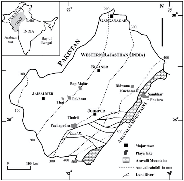
1. Increased Monsoon Rainfall
The Thar Desert has defied global aridification trends, witnessing a 64% rise in precipitation between 2001 and 2023. Rainfall increased at a rate of 4.4 mm/year, particularly in the northwestern regions during the summer monsoon.
- Among the 14 major global deserts, only four (Thar, Arabian, Negev, and Eastern Gobi) saw significant rainfall increases, while the Namib Desert experienced a decline.
- This "opposing effect of climate change"—where some deserts get wetter—has directly contributed to vegetation growth.
2. Agricultural Expansion and Groundwater Use
Human interventions, particularly irrigation and farming, have played a crucial role in greening the Thar Desert.
- Cropland expanded by 74% and irrigated areas by 24% between 1980 and 2015.
- Groundwater contributes 55% of the greening annually, while rainfall accounts for 45%.
- Monsoon season: Rainfall drives 66% of vegetation growth.
- Non-monsoon season: Groundwater sustains 67% of greening.
However, excessive groundwater extraction has led to depletion, especially in north-central regions where well levels are declining.
3. Urbanization and Population Growth
The Thar Desert has the highest population growth among global deserts, leading to rapid urbanization.
- Urban areas expanded by 50% to 800% between 1985 and 2020.
- The Indira Gandhi Canal has enhanced water availability, supporting agriculture and settlements.
4. Future Challenges
While projections suggest 20–50% more rainfall in the coming decades, challenges remain:
- Heat extremes may increase energy and irrigation demands.
- Groundwater depletion threatens long-term sustainability.
Conclusion
The greening of the Thar Desert is a complex interplay of climate change (increased rainfall) and human actions (agriculture, urbanization, and groundwater use). While beneficial in the short term, unsustainable water use and rising temperatures could pose future risks to this fragile ecosystem.
Source:
River Basin Management - 24th April 2026
River Basin Management: River Basin Management refers to the integrated planning and use of land, water, and biological resources within a river basin to achieve sustainable development. It treats the entire drainage area as a single unit, balancing upstream–downstream interests. It includes flood control, irrigation, pollution management, and ecosystem conservation. Examples include Ganga Basin Management Plan and Murray-Darling Basin Plan, emphasizing coordinated governance.
Supernovae - 24th April 2026
Supernovae: A supernova is a powerful stellar explosion marking the end of a star’s life cycle, releasing immense energy and heavy elements into space. It occurs either due to the collapse of a massive star’s core or thermonuclear explosion in a binary system. Supernovae are crucial for cosmic evolution, as they create and disperse elements like iron. A famous example is SN 1987A.
River Training - 24th April 2026
River Training: River training involves engineering measures to control river flow and stabilize channels for navigation, flood control, and erosion prevention. It includes embankments, levees, spurs, and channel straightening. Common in flood-prone rivers like the Kosi River, such interventions aim to reduce hazards but may alter natural dynamics, sometimes increasing sedimentation or downstream flooding.
Primate city - 24th April 2026
Primate city: A primate city is a disproportionately large and dominant city in a country’s urban system, far exceeding others in size and influence. It acts as the economic, political, and cultural hub. The concept was given by Mark Jefferson. Examples include Paris and Bangkok, showing urban primacy and regional imbalance.
System analysis - 24th April 2026
System analysis: System analysis is an approach that studies a phenomenon as an interconnected set of components interacting through inputs, processes, and outputs. Widely used in geography, it helps understand complex systems like ecosystems or urban regions. For instance, a river basin can be seen as a system where rainfall (input), runoff (process), and discharge (output) are linked. It reflects holistic and interdisciplinary thinking.
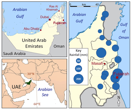
DUBAI FLOODS IN 2024 - 24th April 2026
- In the regions of Arabian Peninsula, deserts lie adjacent to warm oceans, the prevalent conditions typically involve significant evaporation due to the proximity to vast water bodies. However, this moisture is often trapped under layers of sinking air, akin to a cauldron sealed tightly with a lid. This atmospheric configuration stabilizes the environment, preventing the ascent of warm, moist air and thereby inhibiting cloud formation and precipitation.
- A remarkable shift in this dynamic occurred , when an unusual meteorological event led to substantial precipitation in desert areas, demonstrating the complex interplay of atmospheric phenomena. A high-altitude jet stream, which typically remains further north, veered unusually far south. This deviation was a result of the merging of the subtropical jet and the polar jet, two major air currents in the upper atmosphere.
- This shift effectively removed the "lid" that had been keeping the humidity from rising, allowing the accumulated moisture to move upwards freely. Concurrently, a robust influx of moisture-laden air from the northern tropical Indian Ocean began to converge over the desert. The dew point temperatures in the United Arab Emirates reached levels typically seen in the humid rainforests of the Congo basin, an indicator of the exceptionally high moisture content in the air.
- This event serves as a powerful example of how shifts in jet streams and the introduction of cooler air masses can dramatically alter weather patterns in regions typically characterized by arid conditions.
Source:
Places in News - 24 April 2026
1. Amravati
Why in news: In a significant boost to India's deep-tech ambitions and indigenous technological capabilities, Andhra Pradesh has inaugurated India’s first open-access Amaravati Quantum Reference Facility (AQRF)
About:
- It serves as the administrative headquarters of the Amravati District and Division. It is often called "Amba Nagari" after the ancient Ambadevi Temple located at its heart.
- Its ancient name was Udumbaravati (due to an abundance of Audumber trees). In 1722, it was gifted to Ranoji Bhosale and became known as "Bhosle ki Amravati".
- It was a world-renowned center of Buddhism. The Amaravati Stupa (Mahachaitya) was one of the largest in ancient India and gave rise to the distinct Amaravati School of Art, known for its intricate white marble carvings.
2. Subansiri Hydroelectric plant
Why in news: Assam and Meghalaya have declined to procure additional power from the unallocated central pool of the Subansiri Lower Hydroelectric Project (SLHEP), citing concerns over inflated power purchase costs and the availability of cheaper alternative energy sources.
About:
- It is a major run-of-the-river project located at Gerukamukh on the border of Assam and Arunachal Pradesh.
- Built on the Subansiri River, which is the largest tributary of the Brahmaputra.
- The project is being implemented by NHPC Limited (National Hydroelectric Power Corporation).
3. Dudhwa Tiger Reserve
Why in news: 25 Himalayan Griffon vultures died in the Dudhwa Tiger Reserve due to suspected secondary poisoning after scavenging on stray dog carcasses that had consumed pesticide-laced rice.
About:
- It is a complex of three protected areas: Dudhwa National Park, Kishanpur Wildlife Sanctuary, and Katarniaghat Wildlife Sanctuary.
- It represents a classic Terai-Bhabar habitat (Upper Gangetic plains) characterized by Sal forests, marshy grasslands, and oxbow lakes.
- It is the only place in Uttar Pradesh where both Tigers and Rhinos coexist. It is also a global stronghold for the Barasingha (Swamp Deer) and home to over 450 bird species.
- Drained by the Sharda, Geruwa, Suheli, and Mohana rivers (tributaries of the Ghagra).
4. Tadag Taal
Why in news: Almora's Tadag Tal want the seasonal lake to be developed into a perennial waterbody, experts say the area is a wetland and should not be disturbed
About:
- It is a seasonal lake in the Almora district of Uttarakhand.
- It is one of 192 wetlands in Uttarakhand included in ISRO's Wetland Atlas 2021.
- Local residents have formed the Tadag Tal Improvement Committee to demand that the government develop it into a permanent artificial lake to boost tourism and the local economy.
- It lies in the geologically active Ramganga Valley. Geologists believe it was formed centuries ago when a massive landslide blocked the flow of the Tadag stream.
5. Virudhunagar
Why in news: A blast in a fireworks unit caused multiple fatalities, marking a serious safety incident.
About:
- Virudhunagar, a landlocked district in southern Tamil Nadu, is a significant geographical and industrial hub.
- Situated south of Madurai, the district is primarily a flat plain. Its western and northwestern borders are marked by the eastern slopes of the Western Ghats, which provide a scenic and ecologically diverse boundary.
- It has a semi-arid tropical climate. Being in a rain-shadow region, it receives limited rainfall from the South-West Monsoon and is prone to water scarcity.
- The district is drained by seasonal rivers like the Vaippar, Gundar, and Arjuna, which are crucial for local irrigation but dry up during the summer months.
- It features a mix of black cotton soil (Vertisols) and red loam. The moisture-retentive black soil is a major driver for the region's historic prominence in cotton cultivation.

Fortnightly KOSMOS MCQs Practice - 24th April 2026
Q1. Consider the following statements regarding Olive Ridley Turtles:
1. They are known for a unique phenomenon called Arribada, in which thousands of female turtles come ashore to nest simultaneously on the same beach.
2. Odisha’s Gahirmatha Marine Sanctuary is considered the world’s largest rookery for these sea turtles.
Which of the above statements is/are correct?
- 1 Only
- 2 Only
- Both 1 and 2
- Neither 1 nor 2
Q2. The Central Pollution Control Board (CPCB) has recently revised its industry classification system. Which of the following best describes the new "Blue Category" added to the system?
- It is created for industries providing essential environmental services like waste management and biomining.
- It is introduced to classify industries based on their potential for producing noise pollution.
- It categorizes industries involved in reducing water pollutants in lakes.
- It is designed to classify industries that focus on reducing air pollution.
Q3. Consider the following statements:
Statement–I: The mountainous terrain of the Kashmir Valley supports a wide range of habitats that promote the growth of diverse plant species.
Statement–II: The variation in altitude, from low-lying plains to high-altitude alpine meadows, enables the flourishing of distinct types of vegetation, contributing to the valley’s status as an ecological hotspot.
Which one of the following is correct in respect of the above statements?
- Both Statement-I and Statement-II are correct, and Statement-II is the correct explanation for Statement-I.
- Both Statement-I and Statement-II are correct, and Statement-II is not the correct explanation for Statement-I.
- Statement-I is correct, but Statement-II is incorrect.
- Statement-I is incorrect, but Statement-II is correct
Q4. Consider the following statements regarding the Himalayan High Altitude Atmospheric and Climate Research Centre:
1. It is situated at an elevation exceeding 3,000 meters in Himachal Pradesh.
2. It holds the distinction of being India’s first high-altitude climate research facility.
3. Its location is ideal for precise atmospheric observations due to clean air and low pollution levels.
Which of the statements given above is/are correct?
- 1 and 2 only
- 2 and 3 only
- 1 and 3 only
- 1, 2 and 3
Q5. Consider the following statements:
1. The Loss and Damage Fund (LDF) extends financial assistance to Asia-Pacific countries for building climate-resilient infrastructure and advancing renewable energy transitions.
2. India has instituted a legally binding Green Taxonomy that supports the objectives outlined in the National Action Plan on Climate Change (NAPCC).
3. Masdar City in the United Arab Emirates is recognized as a global model of a climate-resilient Special Economic Zone (SEZ).
How many of the above statements is/are correct?
- Only one
- Only two
- All three
- None
Q6. Consider the following statements regarding the Agasthyamalai Biosphere Reserve:
1. This area is part of the Western Ghats, extending through both Tamil Nadu and Karnataka.
2. It is known for the Neelakurinji flower, which blooms only once every 12 years.
3. The region is home to the Kani tribe.
Which of the statements given above is/are correct?
- 1 and 2 only
- 2 and 3 only
- 1 and 3 only
- 1, 2 and 3
Q7. Consider the following statements regarding the Thar Desert:
1. This arid landscape of undulating sand dunes spans portions of Rajasthan, Gujarat, Punjab and Haryana in India, continuing into Pakistan's Sindh and Punjab provinces.
2. Its boundaries are defined by: the Indus River plain (west), Punjab Plain (north/northeast), Aravalli Range (southeast), and Rann of Kachchh (south).
3. The desert contains one of the planet's most extensive deposits of Bituminous coal.
How many of the above statements is/are correct?
- Only one
- Only two
- All three
- None
Q8. Consider the following statements with reference to the project RE-HAB:
1. Its primary objective is to mitigate human-elephant conflicts.
2. The Khadi and Village Industries Commission (KVIC) is the implementing agency for this initiative.
3. It operates as a specialized component under the National Honey Mission.
How many of the statements given above is/are correct?
- Only One
- Only Two
- All Three
- None
Q9. Which of the following is true about the newly inaugurated Pamban Bridge in India?
- A road suspension bridge constructed for vehicular transport.
- Engineered to resist both cyclonic winds and earthquake forces.
- A single-track railway bridge featuring vertical lift mechanism.
- A link between India and Sri Lanka across the Gulf of Mannar.
Q10. Consider the following statements:
1. Formaldehyde is frequently present in domestic cleaning products and pest control chemicals.
2. Inhalation of asbestos fibers may cause severe pulmonary disorders.
3. Carbon monoxide, a colorless and odorless gas, is produced when fuels burn incompletely.
Which of the statements given above is/are correct?
- 1 and 2 only
- 2 and 3 only
- 1 and 3 only
- 1, 2 and 3
Share the article
Edukemy’s Current Affairs Quiz is published with multiple choice questions for UPSC exams
MCQ
Get Latest Updates on Offers, Event dates, and free Mentorship sessions.


Get in touch with our Expert Academic Counsellors 👋
FAQs
Geography Current Affairs focuses on the contemporary issues, events, and developments in the field of geography. It covers recent geographical phenomena, environmental changes, geopolitical shifts, and related news. This differs from regular geography studies which may focus more on foundational concepts, historical contexts, and theoretical frameworks.
Updates are provided regularly to ensure that subscribers stay informed about the latest developments in geography. Typically, updates are provided on a fortnightly basis, depending on the frequency of significant events and changes in the field.
Absolutely. Geography Current Affairs serves as a valuable resource not only for Geography optional but also for GS papers, especially GS Paper 1 (covering Indian Heritage and Culture, History, and Geography of the World and Society) and GS Paper 3 (covering Technology, Economic Development, Biodiversity, Environment, Security, and Disaster Management). It aids in building a holistic understanding of various topics and strengthens answer-writing skills by incorporating contemporary examples and perspectives.
Geography Current Affairs holds immense importance for UPSC preparation, particularly for aspirants opting for Geography optional. It helps candidates stay updated with the latest developments, geographical phenomena, environmental issues, and geopolitical shifts worldwide, aligning them with the dynamic nature of the subject as tested in the UPSC examinations.