Continents and Ocean Basins - Continental Drift Theory and Plate Tectonics Theory
Ocean basins and continents are essential components of the Earth's surface. They have distinct origins and characteristics that shape the planet's topography. Here are the key points:
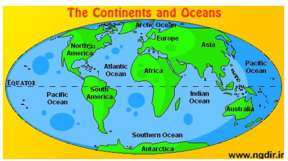
Ocean Basins: Ocean basins are formed through various geological processes, including the upwelling of magma and mantle materials, as well as the splitting and separation of continental crust within the Earth's lithosphere. There are five major ocean basins on Earth:
- Atlantic Ocean: This ocean basin has a relatively straightforward ocean-floor age pattern.
- Southern Ocean: Surrounding Antarctica, this ocean is home to some of the iciest waters on Earth.
- Arctic Ocean: Located around the North Pole, the Arctic Ocean is known for its sea ice and extreme cold.
- Pacific Ocean: The largest of all ocean basins, it covers approximately 30% of Earth's surface.
- Indian Ocean: This ocean basin is situated between Africa, Asia, and Australia.
Continents: There are seven major continents on Earth, each with its own unique characteristics. These continents are:
- Asia: The largest continent, known for its diverse landscapes and cultures.
- Europe: A continent with rich history and a mix of modern and traditional influences.
- Antarctica: The southernmost continent, primarily covered in ice and snow.
- Australia: The smallest continent, often referred to as the "island continent."
- South America: Known for its Amazon rainforest and vibrant biodiversity.
- North America: Home to countries like the United States and Canada.
- Africa: Renowned for its diverse wildlife and vast deserts.
These continents play a significant role in the distribution of land and resources across the globe. They are also home to a wide range of ecosystems, cultures, and geological features.

Map showing oceans and continents on earth
CONTINENTAL DRIFT THEORY
Alfred Wegener, a German meteorologist, introduced the continental drift theory in 1912 to explain the arrangement of continents and oceans.
According to Wegener's theory:
- Pangaea: Initially, all the continents were part of a single massive landmass called Pangaea, surrounded by a vast ocean named Panthalassa.
- Splitting of Pangaea: Approximately 200 million years ago, Pangaea began to split apart.
- Laurasia and Gondwanaland: The breakup of Pangaea led to the formation of two major landmasses:
- Laurasia: Positioned in the northern hemisphere, Laurasia eventually separated into several smaller landmasses.
- Gondwanaland: Located in the southern hemisphere, Gondwanaland also fragmented into numerous landmasses.
- Resulting Landmasses: From Laurasia, the following continents emerged:
- North America
- Europe
- Asia (except for the Indian subcontinent)
- From Gondwanaland, the following continents formed:
- South America
- Africa
- Indian subcontinent
- Australia
Wegener's theory of continental drift provided a groundbreaking explanation for the current distribution of continents and oceans, even though his ideas were initially met with scepticism but later contributed to the development of the theory of plate tectonics, which is widely accepted today.
The continental drift theory is supported by various lines of evidence, including:
- Jig-saw Fit of Continents:
- The coastlines of continents like Africa and South America seem to match and fit together, as do the coastlines of North America and Europe.
- Rocks of the Same Age Across Oceans:
- Radiometric dating methods have shown that the age of rocks on the Brazilian coast is consistent with the age of rocks in western Africa. This suggests that there was no ocean between these continents during the Jurassic age.
- Tillite Deposits:
- Tillite is a sedimentary rock formed by glacial deposits. The sediments in India match with sediments in six different landmasses in the southern hemisphere, including Africa, the Falkland Islands, Madagascar, Antarctica, and Australia. This indicates a shared history of glaciation.
- Placer Deposits:
- Gold deposits in the Ghanaian coast are found, even though the source rock for gold is not present there. However, the source rock for gold is located on the Brazilian coast. This suggests that the gold deposits in Ghana originated from the Brazilian plateau, implying that Africa and South America were once part of the same landmass.
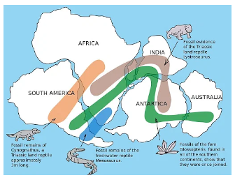
- Distribution of Fossils:
- Similar fossils of prehistoric plants and animals are found on continents that are now widely separated by oceans. This indicates that these continents were once connected.

These lines of evidence collectively support the idea that continents were once joined together and have since drifted apart, providing the basis for the theory of continental drift.
PLATE TECTONIC THEORY
In 1967, McKenzie, Parker, and Margin introduced the concept of plate tectonics, which is based on the theories of seafloor spreading and convection currents. Plate tectonics is a fundamental framework for understanding the movement and interactions of Earth's lithospheric plates.
Tectonic plates, also known as lithospheric plates, are massive, irregularly shaped solid pieces that can consist of either continents, oceans, or a combination of both. These plates can vary in depth, with oceanic plates ranging from approximately 5 to 100 km deep and continental plates from about 10 to 200 km deep.
Tectonic plates move horizontally over the asthenosphere, which is a semi-fluid layer beneath the lithosphere.
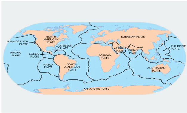
Major Tectonic Plates: There are seven major tectonic plates:
- Antarctica and surrounding ocean plates.
- North American plate.
- South American plate.
- Pacific plate.
- India, Australia, and New Zealand plate.
- Africa and the eastern Atlantic plate.
- Eurasia and adjacent ocean plates, excluding the Indian subcontinent.
It's important to note that both continents and oceans are part of these plates, and they can move. This idea contrasts with Alfred Wegener's earlier suggestion that only continents move.

Types of Plate Boundaries: There are three main types of plate boundaries:
- Divergent Boundaries:
- At divergent boundaries, plates move away from each other, creating new crust as magma rises to fill the gap.
- Three subtypes of divergence boundaries are:
- Ocean to ocean (e.g., Mid-Atlantic Ridge)
- Ocean to continent
- Continent to continent (e.g., Eurasian and African plates)
- Convergent Boundaries:
- Convergent boundaries involve the collision of plates, with one plate sinking beneath the other in a process known as subduction.
- Three types of convergence can occur:
- Between an oceanic and a continental plate
- Between two oceanic plates
- Between two continental plates (e.g., Indian plate and Eurasian plate)
- Transform Boundaries:
- At transform boundaries, plates slide past each other horizontally, causing intense geological activity, such as earthquakes.
- These boundaries do not create or destroy crust but rather redistribute it.
Understanding plate tectonics is essential for comprehending the dynamics of Earth's surface, the formation of geological features, and the occurrence of natural disasters like earthquakes and volcanic eruptions.
FAQs related to this topics
Q1. What are the major ocean basins on Earth?
Ans. The five major ocean basins on Earth are the Atlantic Ocean, Southern Ocean, Arctic Ocean, Pacific Ocean, and Indian Ocean. Each of them has distinct characteristics and plays a vital role in the planet's climate and ecosystem.
Q2. How did ocean basins form, and what geological processes contributed to their creation?
Ans. Ocean basins are formed through geological processes such as upwelling of magma, mantle material, and the splitting of continental crust within the Earth's lithosphere. These processes are part of the broader framework of plate tectonics, which involves the movement and interaction of Earth's tectonic plates.
Q3. What are the seven major continents, and how do they differ in terms of size and characteristics?
Ans. The seven major continents are Asia, Europe, Antarctica, Australia, South America, North America, and Africa. They differ in size, geographical features, ecosystems, and cultural diversity. Asia is the largest continent, while Australia is the smallest.
Q4. What is the continental drift theory, and who proposed it?
Ans. The continental drift theory was introduced by German meteorologist Alfred Wegener in 1912. It proposes that all continents were once part of a supercontinent called Pangaea, which eventually split into smaller landmasses. This theory laid the foundation for our understanding of plate tectonics.
Q5. What evidence supports the continental drift theory?
Ans. The continental drift theory is supported by several lines of evidence, including the matching coastlines of continents, rocks of the same age across oceans, tillite deposits from past glaciations, placer deposits of minerals, and the distribution of fossils that indicate past connections between continents.
Q6. What is plate tectonics, and how does it explain the movement of Earth's lithospheric plates?
Ans. Plate tectonics is a comprehensive theory introduced in 1967 by McKenzie, Parker, and Margin. It explains the movement of Earth's lithospheric plates by considering concepts like seafloor spreading, convection currents in the mantle, and different types of plate boundaries, including divergent, convergent, and transform boundaries.
Q7. How do tectonic plates move, and what is the role of the asthenosphere?
Ans. Tectonic plates move horizontally over the asthenosphere, which is a semi-fluid layer beneath the lithosphere. This movement is driven by convection currents in the mantle, where heated material rises and cooler material sinks, creating a cyclic motion that propels the plates.
Q8. What are the main types of plate boundaries, and what geological features are associated with each type?
Ans. The three main types of plate boundaries are divergent (where plates move apart), convergent (where plates move together), and transform (where plates slide past each other). Each type is associated with distinct geological features like mid-ocean ridges, subduction zones, and strike-slip faults.
Q9. How do scientists study and monitor plate tectonics, and why is it essential for understanding Earth's geology and natural phenomena?
Ans. Scientists use various methods, including GPS, seismology, and geological surveys, to study and monitor plate tectonics. Understanding plate tectonics is crucial for predicting and mitigating natural disasters such as earthquakes and volcanic eruptions, and for comprehending Earth's geological history and the formation of geological features.
Q10. Can tectonic plate movements change over time, and what implications does this have for Earth's future?
Ans. Tectonic plate movements have changed over geological time and will continue to do so. While these changes occur over millions of years, they play a vital role in shaping the planet's topography, including the formation of mountain ranges, ocean basins, and earthquake-prone regions. Predicting the distant future of Earth's continents and oceans is complex due to the vast timescales involved.


