AIR MASSES
- When air presides over a uniform region for an extended period, it assimilates the characteristics of that specific area.
- These uniform areas may encompass extensive ocean surfaces or vast expanses of plains and plateaus.
- Air that acquires distinct features in terms of temperature and humidity is termed an air mass.
- It represents a sizable body of air that exhibits minimal horizontal variance in its temperature and moisture content.
- These air masses play a crucial role in the global planetary wind system and are invariably connected to specific wind belts.
- This correlation aligns them with one of the defined pressure belts, such as the Equatorial Low, Subtropical High, Subpolar Low, and Polar High.
- Several factors influence the movement of winds, including the Coriolis force, which affects the direction and behaviour of wind movements.
- These winds are classified into various categories such as general circulation, permanent, secondary, and local winds.
- Air masses stretch from the Earth's surface to the lower stratosphere and can cover vast distances, often spanning thousands of kilometres.
SOURCE REGION OF AIR MASSES
- Homogeneous terrains, where air masses originate, are designated as source regions. These areas serve as the primary locales where air masses take form.
- High-pressure belts located in the subtropical regions contribute to the generation of tropical air masses, while the regions surrounding the poles are the sources for polar air masses.
- The source region acts as the foundation for establishing an equilibrium of heat and moisture with the air mass overlaying it.
- As the air mass moves away from the source region, its upper layers retain the physical attributes for an extended duration.
- Air masses exhibit stability due to their stagnant nature, hindering convection processes. Consequently, conduction and radiation in such stable air masses prove less effective.
CONDITION FOR FORMATION OF AIR MASSES
- The ideal source regions for air masses are characterised by their expansive coverage and feature slightly divergent air circulations typically associated with high pressure areas.
- An extensive area marked by high pressure but with minimal pressure differences or gradients is considered an excellent source region.
- Regions without major sources are observed in the mid-latitudes, as these areas are predominantly influenced by cyclonic and other disruptive weather systems.
AIR MASSES BASED ON SOURCE REGION
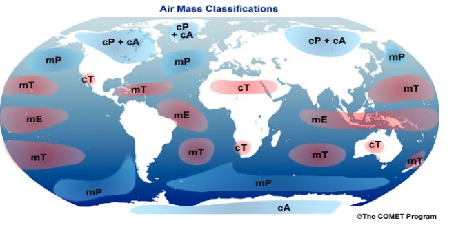
There are five primary source regions known for generating different air masses:
- Warm tropical and subtropical oceans
- Subtropical hot deserts
- Relatively cold high-latitude oceans
- Very cold, snow-covered continents in high latitudes
- Permanently ice-covered continents in the Arctic and Antarctica
From these source regions, distinct types of air masses are identified:
- Maritime tropical (mT)
- Continental tropical (cT)
- Maritime polar (mP)
- Continental polar (cP)
- Continental arctic (cA)
Tropical air masses are warmer, while polar air masses are colder in nature. The processes responsible for heating or cooling the air tend to occur gradually.
COLD AIR MASS
A cold air mass is one which is colder than the underlying surface and is associated with instability and atmospheric turbulence.
Cold source regions (polar air masses)
- Arctic Ocean – cold and moist
- Siberia – cold and dry
- Northern Canada – cold and dry
- Southern Ocean – cold and moist
WARM AIR MASS
A warm air mass is characterised by being warmer than the surface it's above, typically associated with more stable weather conditions. Warm air masses stem from warm source regions and often refer to tropical air masses.
Here are some notable warm source regions:
- Sahara Desert - Warm and dry
- Tropical Oceans - Warm and moist
AIR MASSES CLASSIFIED AS UNDER
Polar
Continental Polar Air Mass (Winter Time) cPK:
- Source regions: Central Canada and Siberia.
- Characteristics: Extremely cold, dry, and stable air mass, making it one of the coldest winter air masses.
- Weather Effects: Often responsible for intense cold waves. These air masses typically have few clouds.
Continental Polar Air Mass (Summer Time) cPW:
- Source regions: Central parts of high-latitude continents, like Central Canada.
- Characteristics: Cool and dry air masses with steep lapse rates.
- Weather Effects: When cPK air masses move out over the ocean, they transform into cPW air masses with haze, fog, and low stratus clouds.
Maritime Polar Air Mass (Winter Time) mPK:
- Source regions: Open areas in higher latitudes, cool and moist with few clouds.
- Characteristics: Lower layers are moist and unstable, while upper parts are dry and cool.
- Weather Effects: These air masses can produce extensive precipitation when they are forced to ascend mountain barriers, often resulting in squally weather.
Maritime Polar Air Mass (Summer Time) mPW:
- Characteristics: In the lower parts, they are cool and moist, but dry aloft.
- Weather Effects: Temperature inversion is produced with moisture discontinuity, and temperatures are slightly higher in the upper layers.
Tropical
Continental Tropical Air Mass:
- Source regions: Subtropical high-pressure land areas.
- Characteristics: High temperatures and low moisture content.
- Weather Effects: These air masses are mainly important in the summer, and they are very hot during that season. In summer, when a cT air mass is aloft over warm, moist air at the surface, it can create convective instability and lead to violent thunderstorms and tornadoes.
Maritime Tropical Air Mass mT:
- Characteristics: Warm, moist, and highly unstable, with convective instability.
Maritime Tropical Air Mass (Winter Time):
- Source regions: Warm oceans in both hemispheres.
- Characteristics: Warm, moist, and unstable air masses with steep lapse rates extending up to the tropopause.
- Weather Effects: When lifted over fronts or high mountains, these air masses produce heavy precipitation.
Maritime Tropical Air Mass (Summer Time):
- Source regions: Located in the belt of great semi-permanent highs of the tropical oceans, including the Caribbean Sea.
EFFECTS OF AIR MASSES ON WORLD WEATHER
- The characteristics of an air mass play a crucial role in influencing the weather that accompanies it.
- Elements such as the vertical temperature distribution, moisture content, and stability affect the weather patterns.
- As air masses move across regions, they transfer atmospheric moisture from oceans to continents, leading to precipitation over land areas.
- Furthermore, air masses transport latent heat, contributing to the redistribution of heat across latitudes, thereby affecting the Earth's overall heat balance.
- The interactions between distinct air masses at their boundaries are responsible for the development of many migratory atmospheric disturbances, like cyclones and storms.
- The nature of the weather associated with these disturbances is determined by the unique characteristics of the air masses involved in these interactions.
FRONTS
Fronts represent the boundaries between air masses of differing temperatures, acting as zones of transition between these distinct air masses.
At times, the transition zone, known as the frontal zone, can be sharply defined.
- Typically prominent in mid-latitude regions (temperate zones: 30° – 65° N and S), fronts are rare in tropical and polar regions.
- A front is a three-dimensional boundary zone created when two contrasting air masses, characterised by different physical properties such as temperature, humidity, and density, converge.
- When dissimilar air masses come together, they don't readily blend due to the effects of converging atmospheric circulation, a relatively low diffusion coefficient, and low thermal conductivity.
- The concept of fronts emerged from the work of Norwegian meteorologists during World War I.
- They coined the term "front" due to their belief that the interaction between unlike air masses resembled a confrontation between opposing armies along a battlefront.
- As one air mass advances over the other, some mixing occurs within the frontal zone. However, for the most part, the air masses maintain their distinct identities, with one displacing the other without fully merging.
FRONT FORMATION
The formation of a front is termed Frontogenesis, and it represents the process of two air masses converging or "warring" with each other.
Conversely, the dissipation of a front is referred to as Frontolysis, indicating that one of the air masses prevails over the other.
- Frontogenesis involves the convergence of two distinct air masses, while Frontolysis occurs when one air mass overrides another.
- In the Northern Hemisphere, Frontogenesis (convergence of air masses) takes place in an anticlockwise direction.
- In The Southern Hemisphere, it occurs in a clockwise direction.
- This directional difference is a result of the Coriolis effect, which influences the movement of air masses in each hemisphere.
Mid-latitude cyclones, also known as temperate cyclones or extra-tropical cyclones, are often a consequence of frontogenesis, as these cyclones form in regions where contrasting air masses converge and generate dynamic weather systems.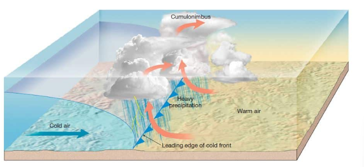
CHARACTERISTICS OF FRONTS
- The thickness of a frontal zone is influenced by the temperature contrast between the converging air masses.
- Generally, air masses with a higher temperature difference result in a less thick, more distinct front, as they don't merge readily due to the pronounced differences in temperature.
- When there is a sudden change in temperature across a front, it often correlates with a change in pressure as well.
- A front typically experiences a shift in wind direction due to the influence of the pressure gradient and the Coriolis force.
- A Wind Shift is defined as a change in wind direction of 45 degrees or more occurring within 15 minutes, accompanied by sustained wind speeds of 10 knots or more throughout the wind shift.
- Frontal activity often leads to cloudiness and precipitation due to the warm air's ascent.
- As warm air rises, it cools adiabatically, causing condensation and subsequent rainfall. Adiabatic Lapse Rate and the release of Latent Heat of Condensation play critical roles in this process.
- The intensity of precipitation associated with a front is contingent upon the steepness of the ascent and the amount of water vapour present in the ascending air.
- Greater moisture content and a steeper slope of ascent tend to result in more intense precipitation.
CLASSIFICATION OF FRONTS
Fronts can be studied under various types based on the mechanism of frontogenesis and the associated weather. Here are the main types of fronts:
STATIONARY FRONT
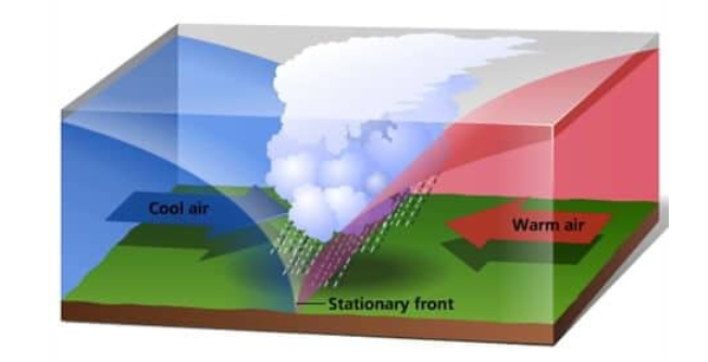
- Stationary front occurs when two air masses meet, but neither one advances over the other.
- As a result, the surface position of the front doesn't change, and it's often depicted as a line with alternating cold and warm symbols on weather maps.
- When a stationary front remains fixed, the winds on both sides of the front blow roughly parallel to the front itself. This setup can lead to relatively prolonged periods of cloudy, wet weather.
- Eventually, if this boundary resumes its forward motion, one air mass will lift over the other.
- If the warmer air advances, it may transition into a warm front, while if the colder air mass moves forward, it can transform into a cold front.
- This shift often occurs after a period of stagnation when the forces driving the air masses become imbalanced.
WEATHER ALONG STATIONARY FRONT
- The presence of a stationary front can lead to the development of cumulonimbus clouds, which are associated with severe weather, including heavy rain, thunderstorms, and even tornadoes in extreme cases.
- When warmer air glides over the cooler air mass at a stationary front, it results in what's called overrunning, leading to frontal precipitation.
- Cyclones moving along a stationary front can exacerbate this situation by dropping substantial amounts of precipitation over a relatively fixed area.
- This prolonged, heavy precipitation can potentially lead to flooding, especially in regions where the cyclones persist or move slowly along the stationary front.
COLD FRONT
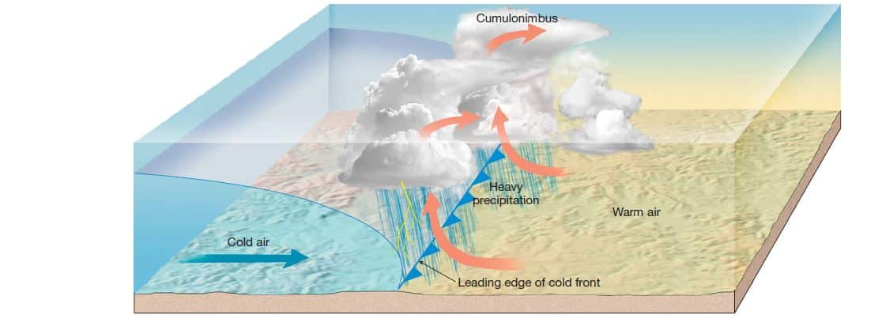
- A cold front occurs when a cold air mass overtakes and replaces a warmer air mass, creating a transition zone.
- This advancing cold air mass forces the warm air to retreat, thereby establishing a boundary known as a cold front.
- Cold fronts typically move at a faster pace than warm fronts, often travelling twice as fast due to their relatively stronger push.
- As the cold air advances, it gradually replaces the warmer air by lifting it, initiating the process of frontolysis.
- This process continues until the warm air mass is completely displaced and uplifted by the cold air, leading to the dissipation of the front.
WEATHER ALONG COLD FRONT
- The weather conditions around a cold front are characterised by a narrow band of cloudiness and precipitation.
- This narrow transition zone is where rapid weather changes occur.
- Thunderstorms are common within the warm sector during the summer months, often resulting in severe weather patterns. In certain regions, like the United States, warm sectors associated with cold fronts can bring about the formation of tornadoes.
- Additionally, the passing of a cold front may cause pronounced and sudden changes in weather.
- Temperatures can rapidly decrease by more than 15 degrees within the first hour of the cold front's passage.
WARM FRONT
- Frontal boundary where warm air is overtaken by advancing cold air.
- In the process, the warm air is lifted from the surface, creating conditions where the warm air is aloft, while cold air resides closer to the ground.
- This movement results in the dissipation of the warm front or the reduction of its influence on the weather. This phenomenon is known as frontolysis.
WEATHER ALONG WARM FRONT
- Warm fronts typically trigger widespread, long-lasting precipitation, generally lighter than the abrupt, intense storms associated with cold fronts.
- As a warm front advances, there's a gradual shift in weather conditions, often leading to rising temperatures, increasing pressure, and changes in wind direction.
- This front's movement often heralds the onset of a warm, moist air mass, leading to an extended period of cloudy and sometimes rainy weather.
OCCLUDED FRONT
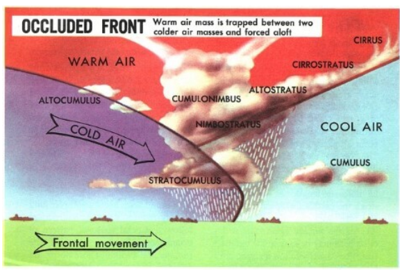
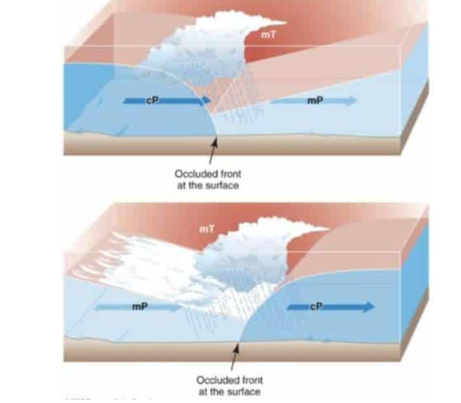
- An occluded front forms when a fast-moving cold front catches up to a slow-moving warm front.
- The warm air trapped between the fronts is forced aloft, and the two air masses essentially merge.
- This results in a more complex front known as an occluded front. There are two types of occlusions: warm occlusions and cold occlusions, each involving various weather conditions and front formations.
WEATHER ALONG OCCLUDED FRONT
- Occluded fronts are often associated with the formation of mid-latitude cyclones, particularly in areas such as western Europe.
- These cyclones are a result of complex interactions between warm and cold air masses and are commonly linked to the occurrence of occluded fronts.
- This intricate mix of weather conditions, including elements of both warm and cold fronts, characterises the often unsettled weather patterns found in these regions.
FAQs covering air masses and fronts:
1. What is an air mass?
Ans. An air mass refers to a large body of air that exhibits relatively uniform temperature, humidity, and stability characteristics. These masses cover extensive regions and take on the qualities of the area over which they form, such as over land or water.
2. How are air masses classified?
Ans. Air masses are classified based on their source regions and properties, including temperature and moisture content. They are categorised as Maritime Tropical (mT), Continental Tropical (cT), Maritime Polar (mP), Continental Polar (cP), and Continental Arctic (cA).
3. What are the main source regions for air masses?
Ans. The primary source regions are warm tropical and subtropical oceans, subtropical hot deserts, high-latitude cold oceans, extremely cold snow-covered high-latitude continents, and the permanently ice-covered Arctic and Antarctic regions.
4. What is a front in meteorology?
Ans. A front is a boundary or transition zone between two different air masses. It's characterised by distinct changes in temperature, humidity, and pressure. Common types of fronts include warm fronts, cold fronts, stationary fronts, and occluded fronts.
5. How do warm fronts and cold fronts differ?
Ans. A warm front forms when warm air advances and replaces cold air, producing gentle, steady precipitation. Conversely, a cold front is created when advancing cold air displaces warm air, leading to abrupt weather changes with intense, sometimes severe, storms.
6. What happens during an occluded front?
Ans. An occluded front occurs when a faster-moving cold front overtakes a warm front, lifting the warm air between them. This can result in complex weather patterns and is often associated with mid-latitude cyclones.
7. What kind of weather is associated with different types of fronts?
Ans. Warm fronts usually bring gentle, prolonged precipitation, while cold fronts trigger rapid weather changes, potentially causing severe storms. Occluded fronts exhibit a combination of warm front and cold front weather characteristics.
8. How do fronts affect local weather conditions?
Ans. Fronts are typically associated with changes in temperature, pressure, cloud formation, and precipitation. They influence the local weather by causing shifts in wind patterns and variations in temperature.
9. What role do fronts play in meteorology?
Ans. Fronts are key features in weather systems and are responsible for creating various weather phenomena. They drive the movement of air masses, leading to changes in weather conditions like storms, precipitation, and temperature fluctuations.
10. Where are fronts commonly found?
Ans. Fronts are typical in mid-latitude regions, such as temperate zones around 30° to 65° N and S latitudes. They're less common in polar and tropical regions, where air masses are more homogeneous.

