TEMPERATURE
The Sun is the primary supplier of energy to Earth's atmosphere, although the atmosphere actually absorbs a relatively small portion of the Sun's heat energy. The majority of the atmosphere's warmth comes from the terrestrial radiation in the form of long-wave energy emitted by the Earth.
The atmosphere's heating and cooling processes involve the direct receipt of solar radiation and the transmission of energy from the Earth through various mechanisms such as conduction, convection, and radiation. These processes contribute to the regulation of the atmosphere's temperature.
TEMPERATURE BELT

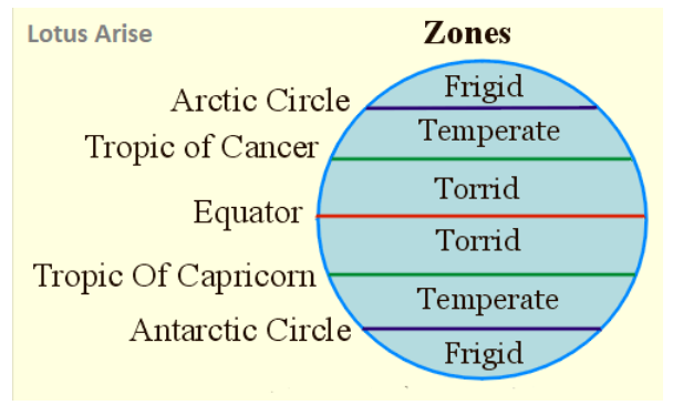
1. TORRID ZONE
- This area, ranging from the Tropic of Cancer (23.5°N) through the Equator (0°) to the Tropic of Capricorn (23.5°S), is commonly known as the Torrid Zone or the Tropical Zone.
- It's considered the hottest part of the Earth where the Sun's rays directly hit at least once a year.
2. TEMPERATE ZONE
- The temperate zones are the habitable areas on Earth, located between 23.5° and 66.5° in both hemispheres.
- These regions experience moderate, bearable temperatures.
3. FRIGID ZONE
The Frigid Zone is situated beyond the polar circles at latitudes higher than 66.5° in both the Northern and Southern Hemispheres.
PRESSURE BELTS

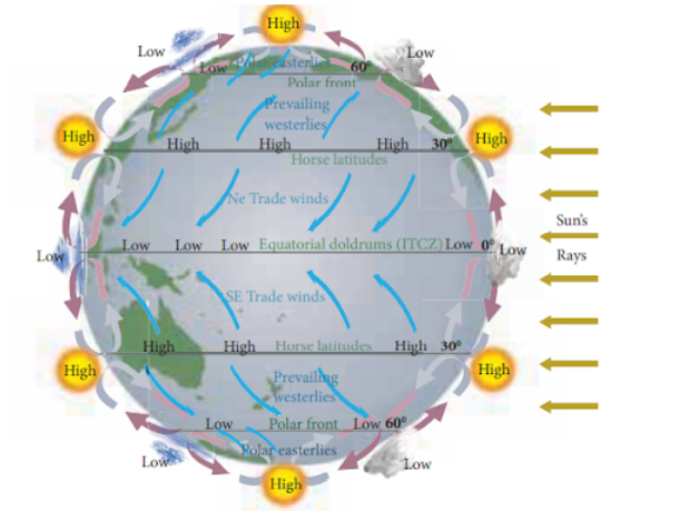
1. EQUATORIAL LOW PRESSURE BELT
- The Equatorial Low-Pressure Belt is positioned between 0°N to 5°N and 0°S to 5°S.
- It is characterised by high temperatures, causing the air in this area to warm, expand, and subsequently ascend, creating a region of low pressure.
- Winds originating from the subtropical high-pressure belt travel towards the equatorial low-pressure belt.
- The Coriolis effect influences these winds, causing deflection to the right in the Northern Hemisphere and to the left in the Southern Hemisphere, resulting in the formation of the northeast and southeast trade winds, respectively.
- The convergence of the northern and southern hemisphere trade winds forms the Intertropical Convergence Zone (ITCZ). The ITCZ shifts position, moving north and south in tandem with the apparent movement of the sun. This area experiences calm conditions and is often described as the "Doldrums."
2. SUBTROPICAL HIGH PRESSURE BELT
- The Subtropical High-Pressure Belt is situated between 30°N to 35°N and 30°S to 35°S.
- Air rising over the equatorial region cools upon reaching higher altitudes and then moves poleward.
- When this cool air collides with the air coming from polar areas at high altitudes, it descends over subtropical latitudes, leading to the establishment of a high-pressure zone along these latitudes.
- The descending air divides into two branches: the trade winds, which head towards the equator, and the westerlies, which move toward the poles.
- In the Northern Hemisphere, the westerlies shift rightward, while in the Southern Hemisphere, they veer leftward.
- This area of high pressure is also known as the "Horse Latitude."
Historical tales suggest that to prevent ships from slowing down or becoming becalmed due to the high-pressure conditions, horses on board were jettisoned into the sea.
3. SUBPOLAR LOW PRESSURE BELT
- The Subpolar Low-Pressure Belt spans between 60°N to 65°N and 60°S to 65°S.
- Here, warm westerly winds originating from the subtropical areas move toward the poles. These winds clash with the cold polar easterly winds originating from the polar high-pressure region.
- When this collision occurs, the air rises, generating a subpolar low-pressure zone.
- This region often undergoes stormy weather and experiences cyclonic activity, especially during the winter months.
4. POLAR HIGH PRESSURE BELT
- The Polar High-Pressure Belts are situated between 85°N to 90°N and 85°S to 90°S.
- These areas experience consistently low temperatures due to inclined solar radiation and reduced insolation.
- Consequently, the polar regions develop high-pressure systems.
IMPORTANT-
- The equatorial low-pressure and polar high-pressure belts aren't permanent; they shift with the apparent movement of the sun.
- During winter in the northern hemisphere, they shift southward, while in summer, they move northward.
- The equatorial low-pressure and polar high-pressure belts are the result of high and low temperatures, respectively. They're referred to as "thermally formed pressure belts."
- Meanwhile, the subtropical high-pressure and subpolar low-pressure belts form due to the movement and collision of wind systems and are named "dynamically formed pressure belts."
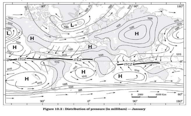
PRESSURE BELT IN JANUARY
- During winter, the pressure belts shift southward from their typical annual positions, and the opposite occurs in the southern hemisphere.
- The shift is relatively less in the southern hemisphere, primarily due to the prevalence of water.
- The distribution of continents and oceans significantly influences pressure distribution.
- In winter, the continents become cooler compared to the oceans, leading to the development of high-pressure centres.
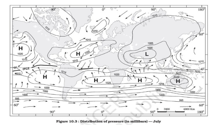
- Conversely, during summer, the continents tend to be warmer and develop low-pressure areas, while the opposite occurs over the oceans.

PRESSURE BELT IN JULY
- In the northern hemisphere, during summer, the thermal equator—where temperatures are highest—moves north of the geographical equator.
- Consequently, the pressure belts also shift slightly northward from their average annual locations.

FAQs related to temperature and pressure belts:
1. What are temperature belts on Earth?
Ans. Temperature belts are regions on Earth characterised by distinctive average temperatures. They include the Torrid Zone, Temperate Zones, and the Frigid Zones.
2. What defines the Pressure Belts on Earth?
Ans. Pressure belts are the result of variations in air pressure across the planet, creating distinct zones with specific weather patterns. These belts include the Equatorial Low, Subtropical Highs, Subpolar Lows, and Polar Highs.
3. What causes the differences in temperature belts?
Ans. The varying angle at which the Sun's rays strike the Earth's surface generates different temperature zones. It's influenced by the Earth's curvature and the Sun's angle of incidence.
4. How does air pressure vary across Pressure Belts?
Ans. Air pressure changes due to temperature variations, resulting in the formation of Pressure Belts. Warm air creates low pressure, while cold air generates high pressure areas.
5. Why are these belts significant in understanding weather patterns?
Ans. These belts determine climate and weather patterns, affecting wind movement, precipitation, and temperature fluctuations across different regions.
6. Where are the Pressure and Temperature belts located?
Ans. Pressure belts, like the Subtropical Highs and Equatorial Low, are found around specific latitudes. Temperature belts, such as the Torrid Zone, Temperate Zones, and Frigid Zones, spread across latitudinal bands on the Earth.
7. What is the impact of these belts on climate?
Ans. Pressure belts regulate wind directions, affecting weather patterns and contributing to the overall climate of an area. Temperature belts dictate the type of weather conditions experienced within different latitudinal zones.
8. How do these belts influence global air circulation?
Ans. The Pressure Belts help determine the atmospheric circulation, steering winds from areas of high pressure to low pressure. This movement is critical in shaping weather systems worldwide.
9. What is the connection between temperature and pressure belts?
Ans. Temperature and pressure belts work hand in hand. Changes in temperature impact air pressure, thus influencing the creation and stability of pressure belts.
10. Do these belts remain static throughout the year?
Ans. No, these belts shift slightly throughout the year due to the Sun's apparent movement and other climatic factors, influencing seasonal weather changes globally.

