Jet streams are like fast-moving rivers of air high up in the sky. They form when warm air meets cold air in the atmosphere. These powerful air currents play a significant role in shaping our weather patterns.
- There are two main jet streams near the Himalayas: the western jet stream to the north and the eastern jet stream to the south.
- The eastern jet stream can sometimes extend as far south as 15 degrees north latitude. When this happens, it has a big impact on the southwest monsoon and can lead to heavy rainfall.
As defined by the World Meteorological Organization (WMO), a jet stream refers to a potent, narrow, and focused current that exists along a quasi-horizontal axis in the upper troposphere or stratosphere. It is recognized by robust vertical and lateral wind shear and typically includes one or more regions of maximum wind velocity.

CHARACTERISTICS OF JET STREAM
- The Jet streams circulate from west to east due to the Earth's rotation, typically observed between the poles and 20 degrees latitude in both hemispheres.
- These currents, also referred to as circumpolar jets, encircle the poles in each hemisphere. They follow a wavy and undulating path.
- Their span becomes more limited during summer due to northward shift and extends up to 20 degrees latitude in winter.
- The width of the jet stream ranges from approximately 40 kilometres, and they have a depth of 2-3 kilometres.
- Jet streams boast high average wind speeds, reaching a minimum of around 120 kilometres per hour in winter and 50 kilometres per hour in summer.
- In winter, the stream travels along the southern slopes of the Himalayas, while in summer, it shifts northward, running along the Himalayan range's edge in early June.
- By late summer (between July and August), it flows along the northern edge of the Tibetan Plateau.
- The periodic movement of the Jet Stream often indicates the onset and retreat of the monsoon.
- The northward movement of the subtropical stream is the first sign of the monsoon's arrival over India.
TYPES OF JET STREAMS
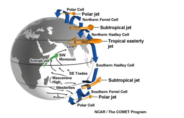
Polar Front Jet Streams
- Forming where the cold polar air mass meets the warm tropical air mass between 40 and 60 degrees latitude, these jet streams are due to the steep thermal gradient.
- Their position is more variable compared to subtropical jets, and they move in an easterly direction.
Subtropical Westerly Jet Streams
- Situated above the subtropical high-pressure belt between 30 and 35 degrees latitude in both hemispheres, these jet streams move regularly from west to east.
- They're produced by the Earth's rotation and maintain a constant flow for most of the year.
Tropical Easterly Jet Streams
This upper-level easterly wind occurs from late June to early September.
Centred around 15°N, 50-80°E, and stretching from Southeast Asia to Africa, these strong upper-atmosphere currents are most intense over the Indian Ocean at an altitude of about 15 kilometres with speeds of up to 40 metres per second.
The Tropical Easterly Jet emerges after the SubTropical Jet moves north of the Himalayas (early June).
Polar Night Jet Streams
- During the prolonged winter nights, the polar-night jet forms at a higher altitude, around 24,000 metres.
- The extreme difference in air pressure in the stratosphere between the poles and the Coriolis effect causes these fast eastward jets at an altitude of about 48 kilometres.
- This phenomenon occurs due to the extreme difference in air pressure during the darker winter months, causing much colder air high above the poles compared to the Equator.
Local Jet Streams
- These Jet Streams are locally created due to specific thermal and dynamic conditions, possessing significance only in their local area.
INFLUENCE OF JET STREAMS ON WEATHER
- Jet streams play a crucial role in maintaining a balance of heat between latitudes by allowing the exchange of air masses.
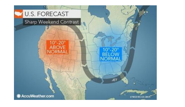
- The Polar Front Jet significantly impacts mid-latitude weather patterns, often leading to severe storms when it intersects with surface wind systems.
- Jet streams influence the pathways of temperate cyclones and significantly affect the distribution of precipitation brought about by these cyclones.
- The Subtropical Jet Stream, along with other temporary jet streams, plays a key role in shaping the Indian Monsoon patterns.
- Jet streams impact the movement of air masses, occasionally contributing to prolonged periods of drought or excessive flooding.
- Their influence on weather patterns is substantial and affects various environmental conditions across regions.
SIGNIFICANCE OF JET STREAM
- Jet streams significantly impact local and regional weather patterns.
- Their relationship with temperate cyclones intensifies weather conditions, often leading to severe storms when they intersect with surface wind systems.
- The occurrence of El Niño and La Niña events can be understood more clearly by observing jet streams.
- Aviators also utilize jet streams to aid in flight; flying in the direction of the jet stream's flow can help expedite travel.
- However, they avoid flying against jet streams due to their unpredictability, as they can cause sudden movements even when weather conditions seem calm and clear.

FAQs about Jet Streams
1. What are Jet Streams?
Ans. Jet streams are fast-moving air currents found high in the atmosphere. They form when warm air meets cold air and have a significant impact on shaping weather patterns.
2. How are Jet Streams defined?
Ans. As per the World Meteorological Organization (WMO), jet streams are powerful, narrow, and focused air currents found along a quasi-horizontal axis in the upper troposphere or stratosphere. They are characterised by strong vertical and lateral wind shear and regions of maximum wind velocity.
3. What are the primary characteristics of Jet Streams?
Ans. Jet streams circulate from west to east due to the Earth's rotation. They typically occur between the poles and 20 degrees latitude in both hemispheres. Their paths are undulating and narrow, with a width ranging from about 40 kilometres and a depth of 2-3 kilometres. These currents have high average wind speeds, with variations between seasons.
4. What types of Jet Streams exist?
Ans. Jet streams include Polar Front, Subtropical Westerly, Tropical Easterly, Polar Night, and Local Jet Streams, each having distinct features and locations. For example, Polar Front Jet Streams form where cold polar air masses meet warm tropical air masses between 40 and 60 degrees latitude.
5. How do Jet Streams influence weather patterns?
Ans. Jet streams maintain a heat balance between latitudes by exchanging air masses. They significantly impact mid-latitude weather disturbances, influencing the intensity and paths of temperate cyclones and the distribution of precipitation. Jet streams also play a critical role in forecasting and understanding phenomena like El Niño and La Niña events.
6. What is the significance of Jet Streams for aviators?
Ans. Aviators use jet streams for flight navigation; flying in the direction of the jet stream's flow can expedite travel. However, aviators avoid flying against jet streams due to their unpredictability, as they can cause sudden movements even under clear weather conditions.
7. Why are Jet Streams important for weather forecasting?
Ans. Understanding jet streams is vital for meteorologists to predict weather systems such as cyclones and monsoons. Their influence on weather conditions across regions is substantial, affecting everything from precipitation patterns to prolonged droughts or flooding.

