Factors Controlling Ocean Temperature and its Distribution
- The temperature of oceans plays a pivotal role in supporting the diverse life forms and regulating their distribution across various ocean depths.
- It significantly influences the movement of vast volumes of ocean water.
- Primarily, the sun stands as the main contributor to the ocean's temperature, imparting heat through insolation—a process where shortwave electromagnetic radiation from the sun is absorbed at the ocean surface.
Nevertheless, the ocean's heating and cooling processes operate at a slower pace compared to land. Besides solar input, ocean water temperature is influenced by various other mechanisms. Heat emanates from the Earth's interior near the ocean floor, conveyed through convection currents to the upper ocean layers, further impacting its temperature.
Understanding the temperature of the oceans holds significant importance in delineating various aspects such as the movement of vast water volumes (both vertical and horizontal ocean currents), the types and distribution of marine organisms at different ocean depths, and the influence on the climate of coastal lands.
SOURCES OF HEAT OF OCEAN
- The sun stands as the primary source of energy through insolation.
- While the ocean receives some heat from the Earth's inner heat (due to the substantial heat within the Earth's interior, where the crust at the sea surface is only about 5 to 30 km thick), this internal heat contribution is relatively minimal compared to the heat received from the sun.
- The diurnal range of ocean temperatures is notably small due to several factors contributing to the slower heating and cooling processes in oceans compared to land.
The primary reasons for the ocean's slower temperature changes include:
- Mixing and High Specific Heat of Water: Oceans take longer to heat or cool due to both vertical and horizontal mixing processes along with the high specific heat of water. It takes more time to heat up a kilogram of water compared to an equal amount of a solid substance at the same temperatures and with an equivalent energy supply.
Heating of Ocean Water:
Ocean water is heated by three main processes:
- Absorption of Sun's Radiation: Direct absorption of solar radiation contributes significantly to the heating of ocean water.
- Convection Currents: The Earth's temperature increases with depth, causing deeper ocean water to heat more rapidly than the upper layers. This temperature discrepancy results in convectional oceanic circulations, facilitating the circulation of heat throughout the water.
- Friction-Induced Heat: Surface wind and tidal currents cause friction, producing heat stress on the water body.
Cooling of Ocean Water:
The ocean water undergoes cooling processes due to:
- Back Radiation: Solar energy received is reradiated as long-wave radiation (infrared radiation) from the sea surface, contributing to the heat budget and cooling.
- Heat Exchange with the Atmosphere: Heat exchange occurs between the ocean and the atmosphere when there is a temperature difference.
- Evaporation: Heat is lost in the form of latent heat during evaporation, where the atmosphere gains this heat in the form of latent heat of condensation.
These complex interactions illustrate the intricacies behind the relatively slow temperature changes in oceanic systems and the multitude of factors contributing to their heating and cooling processes.
FACTORS CONTROLLING TEMPERATURE DISTRIBUTION OF OCEAN
Insolation, heat loss, and various geographical, physical, and atmospheric factors significantly influence ocean temperatures:
- Insolation: The duration and intensity of daily insolation (solar radiation received) impact the heating of ocean waters.
- Heat Loss: Energy loss occurs through reflection, scattering, evaporation, and radiation, affecting the net heat retained by the oceans.
- Albedo: The albedo (reflectivity) of the sea surface, which varies based on the angle of sunlight, influences heat absorption or reflection.
- Physical Characteristics: Sea water's boiling point increases with higher salinity, reducing evaporation rates.
- Submarine Ridges and Sills: These geographical features affect temperature by hindering water mixing across the ridges or sills.
- Ocean Shape and Enclosed Seas: Latitudinally extensive seas in low latitudes tend to have warmer surface water. Enclosed seas in low latitudes have higher temperatures compared to enclosed seas in high latitudes.
- Local Weather Conditions: Weather phenomena like cyclones impact ocean temperatures by affecting heat distribution and water movement.
- Land-Water Distribution: Oceans in the northern hemisphere receive more heat due to their contact with more land mass compared to oceans in the southern hemisphere.
- Prevalent Winds and Ocean Currents: Winds influence temperature through driving warm surface water away or piling up warm water near coasts. This occurs with both off-shore (away from shore) and onshore (toward the coast) winds, impacting water movement and temperature changes. For example, El Niño and La Niña events affect ocean temperatures near the Peruvian coast and the Western Indonesian islands.
- Ocean Currents: Warm currents elevate temperatures in colder areas, while cold currents lower temperatures in warmer regions. For instance, the Gulf Stream (warm current) increases temperatures near the eastern coast of North America and the West Coast of Europe, while the Labrador Current (cold current) reduces temperatures near the northeast coast of North America, near Newfoundland. These currents significantly influence local ocean temperatures.
These multifaceted factors collectively contribute to the dynamic and diverse temperature variations observed in oceanic systems globally.
VERTICAL TEMPERATURE DISTRIBUTION OF OCEAN
the ocean is divided into distinct zones based on light penetration:
- Photic (Euphotic) Zone: This zone extends from the upper ocean surface to approximately 200 metres deep. It receives adequate solar insolation, allowing sunlight to penetrate and support photosynthesis. As a result, this zone sustains a variety of marine life due to the availability of light.
- Aphotic Zone: Extending from around 200 metres to the ocean bottom, the aphotic zone does not receive adequate sunlight. Light penetration is insufficient or absent, making this zone perpetually dark. As a consequence, photosynthesis cannot occur here, and the diversity and quantity of life diminish as you descend into deeper, darker waters.
THERMOCLINE
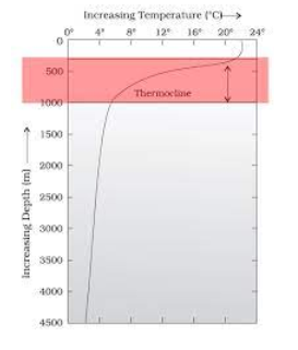
- The ocean profile typically reveals a distinctive boundary between the surface waters and the deeper layers, known as the thermocline.
- This zone usually starts around 100 to 400 metres below the ocean's surface and extends several hundred metres downward.
- The thermocline is characterised by a rapid decrease in temperature as depth increases. Around 90 percent of the total volume of water in the ocean is found below the thermocline in the deep ocean.
- In this zone, temperatures tend to approach 0°C, signifying the cooler conditions prevalent in these deeper layers.

THREE LAYER SYSTEM
The temperature structure of oceans in middle and low latitudes often displays a three-layer system from the surface to the bottom:
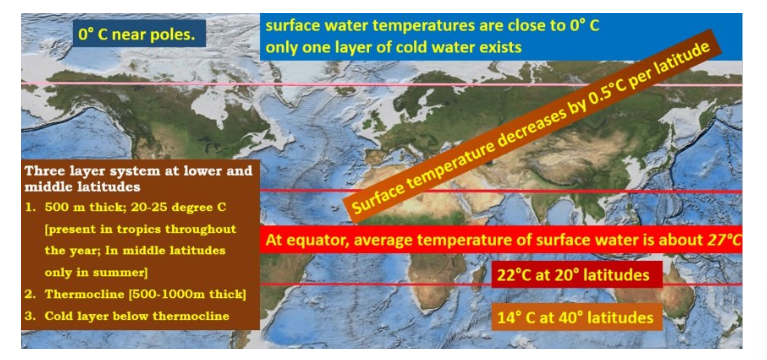
- Surface Layer: The top layer comprises warm oceanic water, approximately 500 metres thick, with temperatures ranging between 20°C to 25°C.
- In tropical regions, this layer remains present throughout the year, while in mid-latitudes, it typically forms only during the summer months.
- Thermocline Layer: Below the surface layer lies the thermocline, a second layer characterised by a rapid decrease in temperature with increasing depth.
- The thermocline can span from 500 to 1,000 meters in thickness.
- Deep Cold Layer: The third layer extends from the bottom of the thermocline to the ocean floor, exhibiting very cold temperatures.
- In this deep layer, the temperature tends to become nearly stagnant, showcasing consistently cold conditions.

GENERAL PATTERN OBSERVED
- In the Arctic and Antarctic regions, the surface water temperatures hover around 0°C, and due to the insulating properties of ice, the temperature change with depth is minimal. This results in a single layer of cold water extending from the surface to the deep ocean floor.
Key points regarding temperature distribution in various regions:
- Rate of Temperature Change: The rate of temperature decrease with depth is more pronounced at the equator than at the poles due to different thermal processes.
- Surface Temperature Influences:
- In equatorial regions, upwelling of bottom water can influence the surface temperature and its variations. For instance, near the Peruvian coast during normal years.
- In cold polar regions, the sinking of cold water and its movement towards lower latitudes can be observed.
- Equatorial Region Variation:
- In equatorial regions, surface water may exhibit lower temperatures and lower salinity due to higher rainfall, whereas the layers below might have higher temperatures.
- Enclosed Seas' Temperature: Enclosed seas in both lower and higher latitudes tend to record higher temperatures at the bottom. For instance:
- Low latitude seas like the Sargasso Sea, Red Sea, and Mediterranean Sea have high bottom temperatures due to consistent high insolation throughout the year and less mixing of warm and cold waters.
- High latitude enclosed seas have warmer bottom layers due to slightly higher salinity and temperature from outer ocean movements as subsurface currents.
- Submarine Barriers Influence: Presence of submarine barriers can create distinct temperature conditions on either side. For example, the Strait of Bab-el-Mandeb has a significant submarine barrier (sill) of about 366 metres.
- The subsurface water in the strait demonstrates higher temperatures compared to water at the same level in the Indian Ocean, showing a temperature difference of around 20°C or more.
HORIZONTAL TEMPERATURE DISTRIBUTION OF OCEAN

- The temperature distribution in the oceans exhibits a gradual decrease from the equator towards the poles, with the average surface water temperature at about 27°C.
- The rate of temperature decrease with increasing latitude is generally around 0.5°C per latitude.
Key points regarding isothermal lines and their implications:
Horizontal Temperature Distribution:
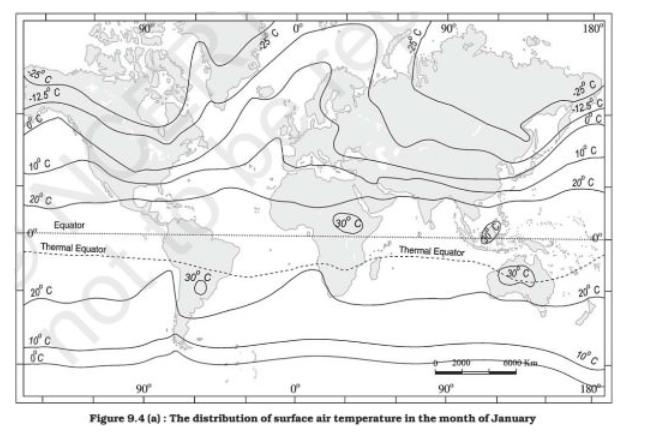
- Isothermal lines are lines connecting areas of equal temperature, revealing the horizontal temperature distribution.
- Closely spaced isotherms indicate higher temperature differences, while widely spaced isotherms signify lower temperature variations.
February Isotherm Example:
- In February, isothermal lines are closely spaced in the southern part of Newfoundland, near the west coast of Europe and the North Sea.
- The isotherms then widen to create a bulge towards the north near the coast of Norway.
Cause of Isothermal Phenomenon:
- This phenomenon is caused by the interactions of ocean currents.
- For instance, the cold Labrador Current flowing southward along the North American coast sharply reduces the temperature of the region more than in other places at the same latitude.
- The warm Gulf Stream proceeds towards the western coast of Europe, elevating the temperature of the west coast of Europe.
- These contrasting currents contribute to the distinct temperature patterns along the isothermal lines.
RANGE OF OCEAN TEMPERATURE
- The oceans and seas exhibit slower heating and cooling processes compared to land surfaces.
- Even when solar insolation is at its maximum at noon, the ocean surface temperature peaks around 2 p.m.
Key points on ocean temperature fluctuations:
- Diurnal Temperature Range: The daily temperature range in oceans and seas is typically very small, about 1 degree. The highest surface water temperature occurs at 2 p.m., and the lowest temperature occurs at around 5 a.m.
- Influence on Diurnal Range: A clear sky and calm atmosphere contribute to the highest diurnal temperature range in oceans.
- Annual Temperature Range: The annual temperature range is affected by annual variations in insolation, nature of ocean currents, and prevailing winds. The maximum and minimum temperatures in oceans are slightly delayed compared to land areas, with the maximum occurring in August and the minimum in February. This variation explains why intense tropical cyclones often occur between August and October.
- Regional Temperature Differences: The northern parts of the Pacific and Atlantic oceans exhibit a greater temperature range compared to their southern regions. This discrepancy is due to differences in the force of prevailing winds from land and more extensive ocean currents in the southern regions.
- Periodic Fluctuations: Alongside annual and diurnal temperature ranges, periodic fluctuations exist in sea temperature. For instance, the 11-year sunspot cycle can cause sea temperatures to rise following an 11-year cycle.
FAQs regarding temperature distribution of ocean
1. What are the primary contributors to ocean temperature, and how do they differ from land surfaces?
Ans. Ocean temperatures are primarily influenced by solar insolation, where the sun's energy heats the ocean surface. This heating process occurs slower in oceans than on land.
2. How does the diurnal temperature range vary in oceans compared to land surfaces?
Ans. Ocean temperatures exhibit a small diurnal range, barely 1 degree, with the highest surface temperature occurring around 2 p.m. and the lowest at 5 a.m.
3. What factors affect the annual and diurnal temperature range of oceans?
Ans. Annual and diurnal temperature variations are influenced by factors such as insolation variations, the nature of ocean currents, prevailing winds, and regional differences. The maximum and minimum ocean temperatures are slightly delayed compared to land areas.
4. Why do ocean temperatures vary regionally?
Ans. Regional differences in ocean temperature ranges occur due to disparities in prevailing winds and ocean currents. For instance, the northern Pacific and Atlantic oceans exhibit a greater temperature range than their southern counterparts.
5. How do various factors impact the horizontal temperature distribution in oceans?
Ans. Ocean temperature distribution varies from the equator to the poles. Isothermal lines, connecting areas of equal temperature, illustrate these variations, showcasing more closely spaced lines with higher temperature differences.
6. What are the different layers within the ocean and how do they affect temperature distribution?
Ans. The ocean is divided into layers, including the surface layer, thermocline, and deep cold layer. These layers, with varying temperatures, play a significant role in the distribution of temperatures within the ocean.
7. What are the sources of heat for the ocean, and how do they influence its temperature?
Ans. The primary source of heat for oceans is the sun through insolation. Additionally, heat from the Earth's interior and various processes like absorption of solar radiation and ocean currents impact ocean temperatures.
8. How do ocean temperature patterns change across latitudes and in specific geographic areas like enclosed seas?
Ans. Ocean temperatures vary with latitude, influenced by factors like upwelling of bottom water, movement of cold water, prevailing winds, and differences in enclosed seas in both low and high latitudes.
9. Are there periodic fluctuations in ocean temperatures, and if so, what causes them?
Periodic fluctuations in sea temperatures occur due to factors such as the 11-year sunspot cycle, influencing temperature rise in intervals.
10. Why does ocean surface temperature peak later in the day compared to land surfaces?
Ans. Oceans heat and cool slower than land surfaces, resulting in the highest surface temperature occurring at around 2 p.m. due to these delayed heating and cooling processes.

