- A landform is a small to medium-sized feature on the Earth's surface, and when several of these landforms are found together, they collectively form landscapes.
- Each landform results from the actions of specific geomorphic processes, whether they are internal (endogenic) or external (exogenic), and various agents such as rainfall, wind, glaciers, or waves.
- Each landform has its unique physical characteristics, size, and nature, and once they are formed, they can continue to change over time due to the ongoing actions of geomorphic processes and agents.
- The evolution of landforms describes the stages of transformation from one landform to another or the changes that individual landforms undergo once they are initially created. Therefore, a landform progresses through stages of development, much like youth, maturity, and old age in a living being.
- Erosion and deposition are two essential aspects in this evolution. Most geomorphic processes are not immediately observable because they occur slowly over extended periods.
- The evolution of landforms depends on geomorphic agents, such as running water, groundwater, glaciers, waves, and winds. These agents cause both the reduction of landmasses through erosion and the formation of new landforms through deposition. Erosion and deposition are processes that continually alter the Earth's surface.
RUNNING WATER
- Running water is one of the principal geomorphic agents that significantly contribute to the erosion of land surfaces. It manifests in various forms such as streams or rivers within valleys and overland flow as sheets on general land surfaces.
- Rivers in their early stages, particularly those flowing over steep slopes, are vigorous and tend to create erosional landforms due to their forceful flow.
- Over time, these fast-flowing streams gradually reduce in velocity as continuous erosion occurs, transforming them into gentler courses, which in turn, promote active deposition. Rivers flowing over medium to gentle slopes result in greater deposition, allowing for the formation of depositional landforms.
- As rivers become gentler due to sustained erosion, the primary action shifts from downward cutting to lateral erosion of the banks. This lateral erosion contributes to the reduction of hills and valleys, eventually resulting in the transformation of these landscapes into broader, more level plains.
EROSIONAL LANDFORMS FORMED BY RUNNING WATER
Landforms sculpted by the actions of rivers and their erosion possess distinctive shapes and dimensions. Various types of valleys, potholes, plunge pools, and river terraces are some of the significant landforms shaped by river activity.
- Valleys: Formed through the gradual development of rills and gullies, valleys can vary in size and shape. They encompass different types like V-shaped valleys, canyons, and gorges.
- Gorge: Characterised by a narrow and deep profile with steep slopes, gorges form through active down-cutting. They are equally wide at the top and bottom and usually develop in hard rocks.
- Canyon: Typically found in horizontally bedded sedimentary rocks, canyons are wider at the top than at the base. The Grand Canyon in Arizona, USA, is the largest in the world. In India, Gandikota's canyon along the Pennar river is known as the Great Canyon of India.
- V-shaped Valley: Shaped by a river's steep slope, these valleys exhibit a narrow and deep profile.
- Potholes: These small cylindrical depressions occur in the rocky beds of river valleys, primarily formed in coarse-grained rocks like sandstones and granites.
- Plunge Pool: Formed by the erosive force of falling water at a waterfall's base, plunge pools are deep depressions in a stream bed.
- Incised or Entrenched Meanders: Meanders formed in hard rocks result in deep, wide courses due to lateral erosion. Commonly seen in floodplains or delta plains, these meanders can be deeply cut into the landscape.
- River Terraces: Narrow, step-like flat surfaces located on the sides of a valley floor, these terraces represent former valley levels. They denote the past stages of valley floors.
DEPOSITIONAL LANDFORMS
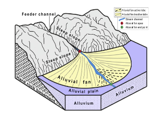
Alluvial Fans:
- Situated at the bases of mountain ranges, alluvial fans are formed when streams transporting a coarse load from mountain slopes deposit this load as a broad, cone-shaped formation.
- Comprising gravel, sand, and other small sediment particles, alluvial fans take on a fan-like appearance.
- Over time, the streams traversing these fans alter their course and develop multiple channels known as distributaries.
- In humid areas, alluvial fans often exhibit low cones with gentle slopes. In arid and semi-arid regions, these fans present themselves as high cones with steeper inclines.

Delta:
- Generally observed in the mature stages of a river, a delta represents a triangular-shaped landform formed by the accumulation of alluvial deposits at the river mouth.
- Deltas differ from alluvial fans in their well-sorted and stratified deposits. Coarse materials settle first, while finer sediments like clays and silts are carried further into the sea.
Floodplain:
- A floodplain constitutes a significant river deposition landform, characterised as a flat land area adjacent to a river that extends from the channel's edge to the base of the valley walls. It is subject to flooding during periods of high discharge.
- The active floodplain, situated on the riverbed's deposits, and the inactive floodplain, positioned above the bank, constitute the two zones of the floodplain.
Natural Levees and Point Bars:
- Natural levees develop alongside major rivers, taking the form of low, linear ridges of coarse deposits aligned parallel to the riverbanks, often forming distinctive mounds.
- Point bars, also known as meander bars, are found on the concave side of large river meanders. These bars result from sediment deposition in a linear arrangement by the flowing water along the banks. They feature a mixture of sediment sizes and maintain a relatively uniform profile and width.
Meanders:
- Meanders are loop-like channel patterns formed over floodplains and delta plains and represent a specific type of channel pattern within a river's course.
- These patterns are a result of both erosional and depositional processes and are characteristic landforms primarily found in the middle and lower segments of a river.
- They form due to various factors:
- Water flowing over gentler slopes tends to work laterally on the banks.
- The unconsolidated nature of alluvial deposits that make up the banks results in various irregularities, which can be utilised by water applying lateral pressure.
- The Coriolis force, acting on the fluid water, causes deflection similarly to how it affects the wind.
- Within meanders, active deposition typically occurs along the concave bank, while erosion is predominant along the convex bank.
- As meanders extend and develop into deep loops, they may experience erosion at certain points, resulting in the creation of ox-bow lakes.
GROUNDWATER
In regions where rocks rich in calcium carbonate, such as dolomite or limestone, are present, the combined action of groundwater and surface water leads to the formation of diverse landforms through chemical processes involving solution and precipitation deposition.
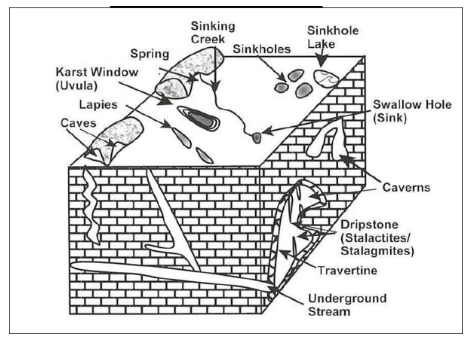
The distinctive landforms resulting from the action of groundwater in such limestone, dolomite, or gypsum regions are collectively known as Karst topography. This nomenclature is derived from the unique terrain developed in the limestone formations of the Karst region situated near the Adriatic Sea in the Balkans.
EROSIONAL LANDFORMS DUE TO GROUNDWATER
- Sinkhole - A sinkhole is a typically circular opening that widens towards the base, varying in size from a few square metres to a hectare. Depths can range from less than half a metre to over thirty metres. Sinkholes formed primarily by the dissolution process are termed solution sinks and are often concealed by a layer of soil, resembling shallow water pools.
- Doline/Collapse Sinks - When a void or cave underground leads to the collapse of the sinkhole's base, forming a large hole, it's referred to as a collapse sink. Occasionally, the term 'doline' is used for such formations.
- Uvala - A compound sinkhole created by the amalgamation of smaller sinkholes is termed a uvala or valley sink.
- Lappies - These irregular grooves and ridges are the result of the dissolution of limestone surfaces.
- Caves - Caves are natural hollow spaces, usually with an opening that allows streams to flow through. Those with entrances on both ends are known as tunnel caves.
 LANDFORMS DEVELOPED BY ACTION OF GROUNDWATER
DEPOSITIONAL LANDFORMS FORMED BECAUSE OF GROUNDWATER
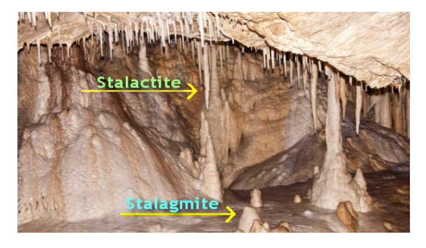
- Stalactite - Stalactites are icicle-shaped calcium carbonate formations hanging from cave ceilings. They generally have a broader base and taper towards their free ends.
- Stalagmite - Stalagmites are calcium carbonate deposits rising upwards from the floor of caves. They can take various forms, from columns to discs, featuring either a smooth, rounded upper end or a concave depression resembling a miniature crater.


