- Latitudes and longitudes serve as imaginary lines for pinpointing a location on Earth. The Earth's shape is a Geoid, and the coordinates of a place can be specified using latitudes and longitudes.
Introduction
- These lines delineate the relative position of a point based on angular distances from the Earth's center in the North to South (longitude/meridians) and East to West (latitude/parallels).
- Longitudes and latitudes are measured in degrees, with further subdivisions into minutes and seconds for greater precision—60 minutes (') per degree and 60 seconds (") per minute.
- The intersecting lines create a network known as graticules or grids.
Latitudes
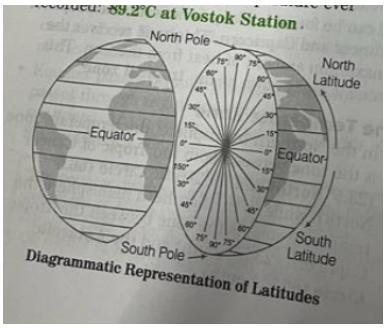
- Latitudes represent the angular distance of a point on Earth's surface, measured in degrees from the center of the Earth.
- The equator marks the longest parallel latitude. The gap between the longest and shortest days increases with latitude.
- Due to the Earth's slight flattening at the poles, the linear distance of a degree of latitude at the pole is slightly longer than at the equator.
- The equator experiences the minimum annual temperature range.
Important Parallels of Latitudes include:
- Equator: An imaginary line dividing the globe into two equal parts.
- The Earth is divided into two halves: the Northern hemisphere and the Southern hemisphere.
- The Equator, representing zero degrees latitude, divides these hemispheres. The distance from the Equator to the poles is one-fourth of the Earth's circumference, measuring 90°.
- The Equator is the largest circle that can be drawn around the Earth, with a total length of 40,076 km.
- At 90° North latitude, we find the North pole, and at 90° South latitude, the South pole. Parallels north of the equator are North latitudes, while those south of the equator are South latitudes, indicated by N or S following the value of each latitude.
- The equator receives maximum insolation, as the Sun's rays fall vertically on it on March 21st and September 23rd. This results in high temperatures and low annual and daily temperature differences.
- The equator's temperature leads to a deficiency in the winter season, with consistent day and night durations throughout the year.
- As we move towards the poles, Earth's gravity increases gradually, reaching its maximum at the poles and minimum at the equator due to the Earth's somewhat flat shape at the poles.
- The equator passes through three continents—Asia, Africa, and South America—and divides the Congo River in Africa twice. It also passes through Lake Victoria, situated on the borders of Kenya, Uganda, and Tanzania.
Tropic of Cancer
- The Tropic of Cancer, located at 23.5°N, divides India into nearly two equal parts, passing through Asia, Africa, and Central America. It traverses 18 countries, including Mexico, Algeria, Egypt, Libya, India, Saudi Arabia, China, and others. The Tropic of Cancer crosses various water bodies like the Indian Ocean, Atlantic Ocean, Pacific Ocean, Red Sea, and Gulf of Mexico.
- The Earth's tilt on its axis causes opposite seasons in the Northern and Southern hemispheres. The Northern hemisphere, known as the Land Hemisphere, contains the majority of Earth's landmass.
Tropic of Capricorn
- The Tropic of Capricorn, at 23.5°S in the Southern Hemisphere, experiences summer on December 22nd when the Sun's rays fall vertically. This leads to long days and short nights in the Southern hemisphere.
- This circle traverses three continents: South America, Africa, and Australia.
- The Tropic of Capricorn passes through 12 countries, including Brazil, Paraguay, Argentina, Chile, French Polynesia (France), Botswana, Madagascar, Mozambique, South Africa, Togo, Namibia, and Australia.
Arctic Circle:
- The Arctic Circle is the northernmost of the five major latitude regions on Earth's map.
- At an angular distance of 66.5°N from the equator in the Northern hemisphere, it is known as the Arctic Circle.
- Due to this angular distance, the Sun's rays fall obliquely on the Arctic Circle's areas, resulting in limited insolation and an extremely cold climate.
- The Arctic Circle passes through regions such as the Arctic Ocean, the Scandinavian Peninsula, North Asia, North America, and Greenland.
- It intersects eight countries, including Norway, Sweden, Finland, Russia, the United States of America, Alaska, Canada, and Iceland.
- Moscow in Russia lies south of the Arctic Circle, and it also passes through Canada's Great Weir Lake.
Antarctic Circle:
- Located in the Southern hemisphere, the Antarctic Circle, or Polar Circle, is positioned at an angular distance of 66.5° South of the equator.
- Abundant large icebergs and glaciers characterize this region.
- The entire area is covered in a sheet of snow, earning it the moniker "white continent."
Heat Zones of the Earth:
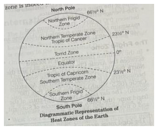
- The frigid zone, temperate zone, and torrid zone constitute the three heat zones on the planet.
- The torrid zone, being closest to the equator, is the hottest among the zones.
- The temperate zone can be broken into two zones along either side of the torrid zone and has temperatures in the range from warm to cool. There are two frigid zones, one at the North Pole and another at the South Pole. The frigid
The Torrid Zone:
- Spanning the area between the Tropic of Cancer (23.5° North) and the Tropic of Capricorn (23.5° South), the torrid zone experiences the Sun directly overhead at least once a year in all latitudes. This positioning allows it to receive the maximum heat from the Sun.
- The torrid zone, located closest to the equator, typically exhibits extremely high temperatures. While it undergoes both wet and dry phases, it lacks the distinct four seasons observed in temperate regions farther from the equator. The temperature in this zone profoundly influences the atmosphere, ecology, and geographical features.
- Positioned midway between the Tropic of Cancer and the Tropic of Capricorn, this zone is often referred to as the tropical zone, receiving the highest amount of solar heat.
The Temperate Zone:
- In the Northern hemisphere, the temperate zone encompasses the region between the Tropic of Cancer (23.5° North) and the Arctic Circle (66.5° North).
- In the Southern hemisphere, it extends from the Tropic of Capricorn (23.5° South) to the Antarctic Circle (66.5° South).
- On Earth, there are two temperate zones.The temperature remains moderate in these zones because the midday Sun never ascends above the Tropics of Cancer and Capricorn, and the angle decreases towards the poles.
- The temperate zones boast the most suitable climates, avoiding the wide temperature variations seen in more extreme climates.
- The average temperature in these zones ranges from 0°C to 20°C, with recorded minimum and maximum temperatures of -40°C and 40°C, respectively.
The Frigid Zone:
- In the Northern hemisphere, it spans between the Arctic Circle (66.5° North) and the North Pole (90° North). In the Southern hemisphere, it extends between the Antarctic Circle (66.5° South) and the South Pole (90° South). At the center of the frigid zone (the pole), a day lasts a year, with six months of sunlight and six months of darkness.
- North Pole: The frigid zones are known as the world's coldest areas, often covered with ice and snow. Due to their distance from the equator, they receive slanting sunbeams.
- Prime Meridian: Summer lasts approximately 2 to 3 months in these locations, with about 24 hours of sunlight during this period. Monthly temperatures in polar regions remain below 10°C. Polar climates cover over 20% of Earth's area. In the Arctic, average January temperatures range from about -40°C to 0°C, with winter temperatures dropping below -50°C. Antarctica, having the coldest climate on Earth, recorded the lowest temperature ever at 89.2°C at Vostok station.
Longitudes
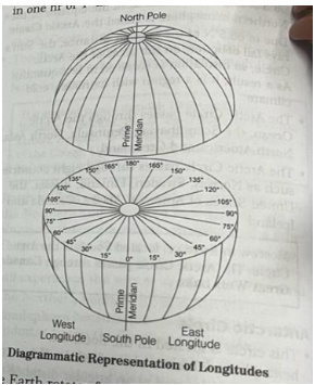
- Longitude is an angular distance, measured in degrees along the equator East or West of the Prime Meridian equivalent to nearly 111 km. On the globe, longitude is shown as a series of semi-circles that run from pole to pole passing through the equator.
- Local time in relation to Greenwich Mean Time (GMT), is sometimes referred to as World Time.
- The Earth makes one complete revolution of 360° in one day or 24 hrs, it passes through 15° in one hr or 1° in four min.

- The Earth rotates from West to East, so every 15° we go Eastwards, local time is advanced by one hour. Conversely, for every 15° we go Westwards, local time is retarded by one hour.
- Places East of Greenwich see the Sun earlier and gain time, whereas, places West of Greenwich see the Sun later and lose time.
- There are 8 countries that Prime Meridian passes through i.e., the United Kingdom (England only). France, Spain, Algeria, Mali, Burkina Faso, Togo and Ghana.
- It traverses six water bodies, including the Arctic Ocean, the Norwegian Sea, the Greenland Sea, the Mediterranean Sea, the Atlantic Ocean, and the Southern Ocean.
Indian Standard Time (IST):
- In India, the longitude of 82° 30° E is considered the standard meridian. The local time at this meridian is adopted as the standard time for the entire country, known as Indian Standard Time (IST). This meridian passes through Mirzapur near Prayagraj.
Daylight Saving Time (DST) Schedule:
- During summer, several temperate countries practice advancing clocks to maximize evening daylight and reduce morning daylight. Typically, clocks are moved forward by 1 hour at the start of spring and backward in autumn. While this benefits retailing, sports, and other activities using sunlight after working hours, it may pose challenges for evening entertainment and occupations tied to the sun.
Greenwich Mean Time (GMT):
- GMT refers to the Mean Solar Time at the Royal Greenwich Observatory's Prime Meridian (0° longitude) in England.
- It is used to avoid ambiguous references to local time zones, providing a clear epoch designation. Apart from Britain, countries like Iceland, Ireland, Portugal, Canary Islands (Spain), Mauritania, Mali, Senegal, Ascension Island (UK), Sierra Leone, Liberia, Ivory Coast, Burkina Faso, Togo, Gambia, Guinea, and Ghana use only GMT standard time.
International Date Line (IDL):
- The International Date Line (IDL) is an imaginary line around 180° North-South on the Earth's surface, with the Bering Strait being its closest point.
- Crossing the IDL results in a change of exactly one day, and it is known as the Line of Demarcation, separating two calendar dates.
- A traveler moving from East to West across the date line loses a day, while the reverse gains a day due to the time difference.
- Magnetic Meridian:The magnetic meridian is an imaginary line connecting the magnetic North to South poles, representing the horizontal component of magnetic lines of force along the Earth's surface.
Prelim Facts
- Which latitude is known as a great circle?
- -Equator (HPSC (Pre) 2014
- distance on the Earth? 1 of latitude would cover approximately how much The term Horse latitude is applied for 3
- -4 North and South latitude (PSC (P) 2011
- Which imaginary line passes through Kenya, Indonesia and Brazil?
- -Equator (UKPSC (PH) 2012)
- The Northern Hemisphere is also known as
- -The land hemisphere (MPPSC (Pre) 2011
- Which imaginary line passes through Paraguay, Argentina and Brazil?
- -Tropic of Capricorn (UPPSC (Pre) 1997
- The time at Cairo is 2 hr ahead of Greenwich hence it is located at
- -30° East longitude (BPSC (Pre) 2011]
- If the time at Greenwich is 7:00 AM, what will be the longitude at the time of 11:00 AM?
- -60° East (Manipur PSC (Pre) 2008
- What is the difference between IST and GMT?
- -5 kr 30 min (UPPSC (Pre) 2011
- Tropical year, lunar month and day all are unit of time except Standard time (UKPSC (Pre) 2016
- If the local time of a place is 6:00 AM and GMT is 3:00 AM, what will be the longitude?
- 45° East (UKPSC (Pre) 2011)
- The distance between two consecutive longitudes (90° E and 92° E) at the poles is
- -0 km (UPPSC (Pre) 2016)
- Sun traverses 1" of longitude at every
- -4 minute (UPPSC (Pre) 2015]
- The total system of parallels and meridians that form a network of intersecting lines is called
- Geographic grid (UPPSC (Pre) 2008]
- Which strait is nearest to the International Date Line?
- -Bering strait (UPPSC (Pre) 2008)
- The 180th Meridian is known as - International Date Line International Date Line passes through which ocean?
- Pacific Ocean (BPSC (Pre) 2001)
- If the time in India is 12:00 noon, the time simultaneously at GMT & International Date Line will be
- -Morning 6:30 and Evening 6:30 (MPSC (Pre) 2020)
- Which latitudes receive the highest insolation on 21st March and 23rd September?
- -0° (MPSC (Pre) 2014
- The country, which has the longest North-South latitudinal extention of its territory is Russia (BPSC (Pre) 2019)
- The total length of Earth's equator is about 40,000 kms [UKPSC (Pre) 2010)
- The Equator, Tropic of Cancer and Tropic of Capricorn, all the three pass through which one continent?
- - Africa (UPPSC (Pre) 2004)
- Which longitude along with the Prime Meridian forms a great circle on the globe?
- -180° (UPPSC (Pre) 2000]
- The basis of deciding standard times of any place is
- - Prime Meridian (BPSC (Pre) 1999]
- When it is noon along 82°30′ E longitude, what degree of longitude will be 6:30 am?
- -At 0° East or West [IAS (Pre) 1994]
- When there is mid-day in the Greenwich local time of a place is 5 O'clock evening at which longitude that place will be located?
- -75° E longitude [UPPSC (Pre2008
Self Check
1. Which pressure belt on the globe is otherwise known as the Horse Latitude?
(a) Equatorial Low
(b) Subtropical High
(c) Mid-Latitude Low
(d) Polar High
2. Indian Standard Meridian passes through the states of
(a) Uttar Pradesh, Madhya Pradesh, Chhattisgarh, Odisha, Andhra Pradesh
(b) Uttar Pradesh, Bihar, Jharkhand, Odisha, West Bengal
(c) Uttar Pradesh, Rajasthan, Maharashtra, Gujarat, Madhya Pradesh
(d) Tamil Nadu, Karnataka, Andhra Pradesh, Odisha, West Bengal
3. Which of the following latitudes passes through the maximum number of Indian states?
(a) 20°N
(c) 24°N
(b) 22°N
(d) 26°N
4. Latitude is the angular distance of a point on the Earth's surface North or South of the equator which is
(a) measured from the centre of the Earth.
(b) measured trom the equator
(c) measured from the Tropic of Cancer or Tropic of Capricorn.
(d) measured from the Poles.
5. In order to find out the absolute location of a place on the map, which of the following will be required?
(a) Latitude of the place alone
(b) Longitude of the place alone
(c) Both latitude and longitude of the place
(d) Neither latitude or longitude of the place
6. Which statement is correct?
RAS/RTS (Pre) 2010
(a) India is situated in Western hemisphere.
(b) Caspian sea is open sea.
c) Rajasthan is situated in a cold desert region.
(d) North and South Poles are opposite poles.
Select the correct answer by using the codes given below.
(a) 1 and 2
(b) 2 and 3
(c) 3 and 4
(d) 1 and 3
8. What is the difference between IST and GMT?
UPPSC (Pre) 2011
(a) 5 hr 10 min
(b) 5 hr 20 min
(c) 5 hr 30 min
(d) 5 hr 40 min
9. If the local time at 80°30'E Longitude Allahabad is Sunday 6:00 am, then what is the local time in Florida, USA located at 82° W Longitude?
(a) Saturday, 6:58 pm
(c) Sunday, 6:58 am
(b) Sunday, 7:02 pm
(d) Saturday, 7:02 am
10. When we consider 15° Meridian on a world map or globe and count them in an Eastward direction starting with Greenwich Meridian 0°. We find that the time of this Meridian is
(a) Same as Greenwich
(b) 1 hr fast?
(c) 1 hr slow
(d) 12 hr fast
11. The Prime Meridian passes through UPPSC (Mains) 2008
- Algeria
- France
- Nigeria
- Portugal
12. Which one of the following straits is nearest to the International Date Line?
UPPSC (Pre) 2008
(a) Malacca Strait
(b) Bering Strait
(c) Strait of Florida
(d) Strait of Gibraltar
13. The imaginary line on the Earth's surface that closely follows the 180° Meridian is
(a) Prime Meridian
(b) Equator
(c) International Date Line
(d) Tropic of Cancer
14. If the time in India is 12:00 noon, what would be the time simultaneously at the Greenwich Meridian and the International Date Line, respectively?
MPSC (Pre) 2020
(a) Morning 6:30 and Evening 6:30
(b) Evening 6:30 and Morning 6:30
(c) Morning 6:30 and Evening 5:30
(b) Evening 6:30 and Morning 5:30
15. Which one among the following statements about the International Date Line is not correct?
JPSC (Pre) 2011
(a) The International Date Line is largel based on the 180° meridian.
(b) The difference in either side of the International Date Line is almost one day.
(c) The difference in time to the extent of one day on either side of the International Date Line is caused by the inclined axis of the Earth.
(d) The International Date Line mostly passes through the Pacific ocean.
16. Which of the following statements are true about latitudes? HPSC (Pre) 2018
- Precipitation, temperature and vegetation vary with latitude.
- Gap between longest day and shortest day increases along with latitude.
- Indira Point is situated at about 6°45' North. Codes
Codes
(a) 1 and 2
(b) 1 and 3
(c) 2 and 3
(d) all of these
Know Right Answer
1 (a)
2 (a)
3 (c)
4 (a)
5 (c)
6 (d)
7 (d)
8 (c)
9 (a)
10 (b)
11 (a)
12 (b)
13 (c)
14 (a)
15 ( c)
16 (d)


