The movement of water through clearly defined channels is termed as 'drainage,' and the interconnected system of these channels constitutes a 'drainage system.'
Drainage Pattern:
The term denotes the arrangement of surface water flow primarily characterized by rivers and basins. The configuration of the drainage system is influenced by various factors, including the slope of the land, geological structure, water volume, and water velocity.
- Definition of Drainage:
Definition: The term "drainage" refers to a region's river system, and a drainage basin is the area drained by a single river system.
- Water Divide and Drainage Basins:
Explanation: Elevated features like mountains or uplands act as water divides, separating two drainage basins.
- River Basins and Watersheds:
Differentiation: River basins are the catchments of major rivers, while watersheds refer to catchments of minor rivulets and rills.
Size Comparison: Watersheds are relatively small, whereas basins cover extensive regions.
- Interconnected Nature of Basins and Watersheds:
Interdependence: What occurs in one part of the basin or watershed directly affects other sections and the entire unit.
Planning Zones: Recognized as suitable zones for micro, meso, and macro planning due to their interconnected nature.
- Indian Drainage System:
Classification: The Indian drainage system is categorized based on the discharge of water into two groups oriented to the sea: Arabian Sea drainage and Bay of Bengal drainage.
- Himalayan and Peninsular Rivers:
Origins: Himalayan and Peninsular rivers have distinct origins in India's primary physiographic areas.
Perennial vs. Seasonal: Most Himalayan rivers are perennial, fed by rain and melting snow. In contrast, a significant number of Peninsular rivers are seasonal, with restricted water flow during dry seasons.
Understanding the nuances of drainage systems, including the interconnected nature of river basins and watersheds, is crucial for effective planning and management at different scales.
Types of Drainage Patterns
1. Dendritic Drainage Pattern:
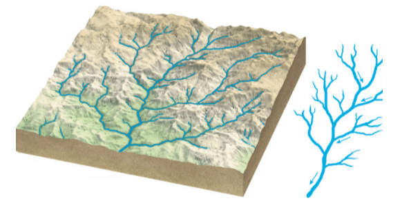
- Description: This is the most common pattern, resembling the branching of tree roots.
- Formation: Develops where the river channel follows the slope of the terrain.
- Characteristics: No specific rock structure; tributaries join larger streams at acute angles.
- Examples: Indus, Ganga, and Brahmaputra rivers in the northern plains.
2. Parallel Drainage Pattern:
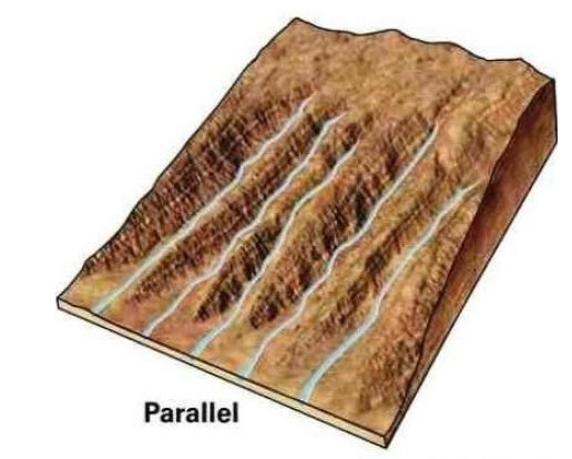
- Description: Develops in regions with parallel, elongated landforms and a pronounced slope.
- Formation: Tributary streams stretch out parallel to the surface slope.
- Examples: Godavari, Kaveri, Krishna, and Tungabhadra rivers originating in the Western Ghats.
3. Trellis Drainage Pattern:
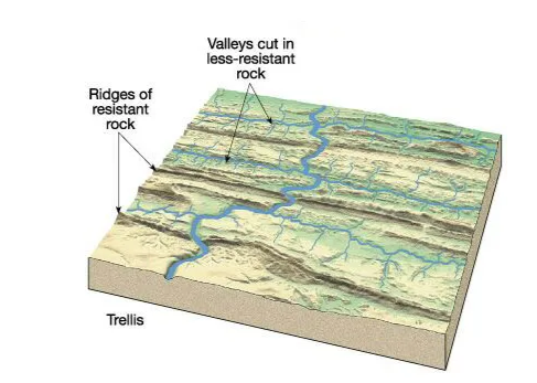
- Description: Develops in folded topography with parallel hard and soft rocks.
- Formation: Down-turned folds (synclines) form valleys for the main channel.
- Characteristics: Primary tributaries flow parallel; secondary tributaries join at right angles.
- Examples: Indus, Ganga, and Brahmaputra rivers in the upper part of the Himalayan region.
4. Rectangular Drainage Pattern:
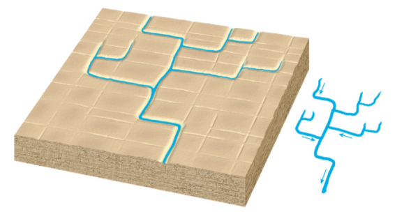
- Description: Found in regions undergoing faulting on strongly joined rocky terrain.
- Formation: Streams follow the path of least resistance, concentrated in areas with weaker exposed rock.
- Characteristics: Tributary streams make sharp bends and enter the main stream at high angles.
- Examples: Chambal, Betwa, and Ken streams in the Vindhya mountain range.
5. Radial Drainage Pattern:
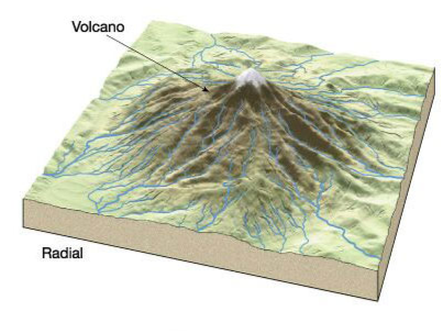
- Description: Develops around a central elevated point, common to conically shaped features like volcanoes.
- Formation: Rivers originate from a hill and flow in all directions.
- Examples: Narmada and Son rivers originating from the Amarkantak range.
6. Centripetal Drainage Pattern:
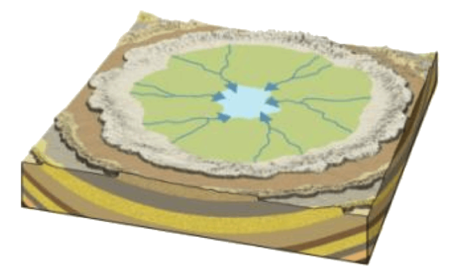
- Description: Opposite of radial; streams flow toward a central depression.
- Characteristics: Streams feed ephemeral lakes during wet periods; lakes evaporate in dry periods.
- Examples: Loktak Lake in Manipur.
Frequently Asked Questions (FAQs) - Drainage Systems
1. What is the definition of drainage?
Answer: Drainage refers to the movement of water through clearly defined channels, and the interconnected system of these channels constitutes a drainage system.
2. What is a drainage basin?
Answer: A drainage basin is the area drained by a single river system, defining a region's river system.
3. How are drainage basins divided?
Answer: Elevated features like mountains or uplands act as water divides, separating two drainage basins.
4. What distinguishes river basins from watersheds?
Answer: River basins are catchments of major rivers, while watersheds refer to catchments of minor rivulets and rills. Watersheds are smaller in size compared to basins.
5. Why are basins and watersheds considered interconnected?
Answer: Actions in one part of the basin or watershed directly affect other sections and the entire unit, making them essential for micro, meso, and macro planning.
6. How is the Indian drainage system classified?
Answer: The Indian drainage system is classified based on the discharge of water into two groups oriented to the sea: Arabian Sea drainage and Bay of Bengal drainage.
7. What distinguishes Himalayan and Peninsular rivers?
Answer: Himalayan rivers are mostly perennial, fed by rain and melting snow, while a significant number of Peninsular rivers are seasonal with restricted water flow during dry seasons.
8. What are the common types of drainage patterns?
Answer: Common drainage patterns include dendritic, parallel, trellis, rectangular, radial, and centripetal.
9. Where is the dendritic drainage pattern commonly found?
Answer: The dendritic pattern is the most common and is found in areas where the river channel follows the slope of the terrain. Examples include the rivers Indus, Ganga, and Brahmaputra in the northern plains.
10. In which regions does the parallel drainage pattern develop?
Answer: The parallel pattern develops in regions with parallel, elongated landforms and a pronounced slope. Examples include the rivers Godavari, Kaveri, Krishna, and Tungabhadra originating in the Western Ghats.
11. What characterizes the trellis drainage pattern?
Answer: The trellis pattern develops in folded topography with parallel hard and soft rocks. Primary tributaries flow parallel, and secondary tributaries join at right angles. Examples include the rivers Indus, Ganga, and Brahmaputra in the upper part of the Himalayan region.
12. Where can we find the rectangular drainage pattern?
Answer: The rectangular pattern is found in regions undergoing faulting on strongly joined rocky terrain. Examples include the streams Chambal, Betwa, and Ken in the Vindhya mountain range.
13. What is the radial drainage pattern associated with?
Answer: The radial pattern develops around a central elevated point and is associated with conically shaped features like volcanoes. Examples include the rivers Narmada and Son originating from the Amarkantak range.
14. Can you explain the centripetal drainage pattern?
Answer: The centripetal pattern is the opposite of radial, where streams flow toward a central depression. Streams feed ephemeral lakes during wet periods, and lakes evaporate in dry periods. An example is Loktak Lake in Manipur.

