- A climatic region is characterized by a consistent and homogeneous set of climatic conditions resulting from a combination of various factors.
- Temperature and rainfall are particularly crucial elements considered in the classification of climates.
- India, as a whole, exhibits a monsoon type of climate.
- However, the intricate combination of weather elements unveils numerous regional variations.
- These variations in climate distribution have led to the identification of different climatic regions across the country.
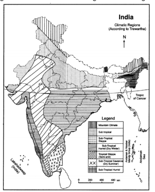
- The classification proposed by Trewartha is found to be more apt for India, as it aligns closely with the distinctive soil, vegetative, and agricultural regions of the country. This scheme accounts for the diverse climatic conditions observed in different parts of India based on the varying distribution of climatic factors.
- In 1954, G.T. Trewartha made modifications to the climatic classification system originally developed by Köppen.
- His empirical classification relies on temperature and precipitation data and employs English alphabets as symbols to represent various climate types.
- When applied to India, Trewartha's scheme categorizes the country into four primary climatic regions, each of which is further subdivided into seven meso-climatic divisions.
- This refined classification provides a detailed and comprehensive understanding of India's diverse climate, taking into account both temperature and precipitation patterns.
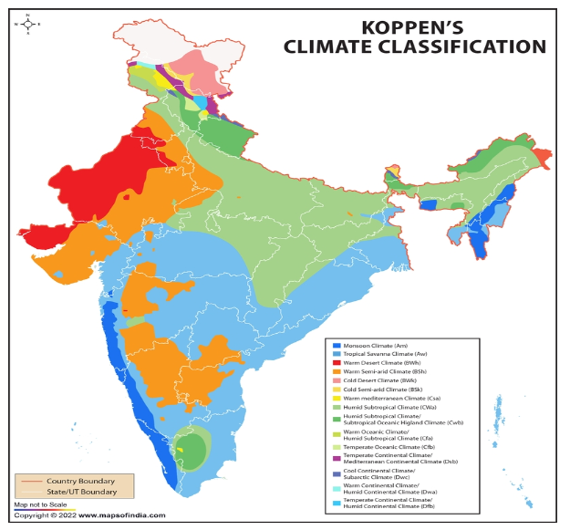
Köppen Climate Classification in India
According to the Köppen climate classification, India is characterized by six distinct climatic regions, each exhibiting unique temperature and precipitation patterns:

Tropical Semi-arid:
- Definition: Regions where rainfall is insufficient to meet the vegetation's year-round needs.
- Examples in India: Eastern parts of the Western Ghats and the Cardamom Hills.
Subtropical Arid Desert:
- Definition: Ecosystems with extremely high temperatures, minimal precipitation, and warm soils.
- Examples in India: State of Rajasthan, where arid desert conditions prevail.
Subtropical Semi-arid:
- Definition: Regions considered the second driest after arid areas, characterized by extremely hot and extremely cold weather with minimal annual rainfall.
- Examples in India: Regions with challenging weather conditions.
Tropical Rainforest:
- Definition: Hot and moist ecosystems with year-round rainfall, featuring dense canopies with three distinct layers of vegetation.
- Examples in India: Western Ghats, states of Andhra Pradesh, Odisha, and Tamil Nadu.
Subtropical Humid:
- Definition: Regions characterized by hot and humid summers, along with cold to mild winters, and moderate rainfall.
- Examples in India: North-eastern part of the country.
Alpine:
- Definition: Regions with extremely cold climates and high precipitation, often observed in mountainous areas.
- Examples in India: Mountainous regions of Himachal Pradesh and Arunachal Pradesh.
The Köppen climate classification provides a comprehensive framework for understanding India's diverse climatic conditions, considering factors such as temperature, precipitation, and specific geographical features in different regions of the country.
Trewartha’s Classification of Climate in India
Trewartha’s climatic classification provides a nuanced understanding of India’s diverse climatic regions. The main climatic categories according to Trewartha's scheme are:

Tropical Rainforest Climate (Am):
- Characterized by high temperatures and heavy precipitation.
- Temperatures consistently above 18.2 °C, with rainfall exceeding 200 cm.
- Includes the western coastal plain, Sahyadris, and parts of Assam and Meghalaya.
- Dominated by dense evergreen forests.
Tropical Savannah Climate (Aw):
- Mean annual temperature around 27°C with less than 100 cm of annual rainfall.
- Features a marked dry season.
- Encompasses greater parts of Peninsular India, excluding coastal plains and western slopes of the Western Ghats.
Tropical Steppe Climate (BS):
- Mean annual temperature approximately 27°C.
- Covers the rain-shadow areas of the Western Ghats, including parts of Maharashtra, Telangana, Andhra Pradesh, Karnataka, and Tamil Nadu.
Sub-tropical Steppe Climate (BSh):
- Semi-arid climate extending over parts of Gujarat, eastern Rajasthan, Mahanadi, Andhra Pradesh, and southern Haryana.
- Mean annual temperature exceeds 27°C, with a mean monthly January temperature of about 15°C.
- High annual temperature range, and mean annual rainfall varies between 60 – 75 cm.
Tropical Arid Climate (BWh):
- Located to the west of the Aravallis, covering the Thar Desert.
- Mean maximum temperature in May and June can surpass 48°C.
- Annual rainfall less than 25 cm, with the lowest recorded in Ganganagar district.
- Natural vegetation consists mainly of thorny bushes.
Humid Subtropical Climate (Caw):
- Occupies the majority of the Great Plains of India, extending from Punjab to Assam.
- Mean January temperature less than 18°C, while the mean maximum in summer may exceed 45°C.
- Annual rainfall varies from 250 cm in the east to about 65 cm in the west.
Mountain Climate (H):
- Found in hilly parts of Jammu and Kashmir, Himachal Pradesh, Uttarakhand, Arunachal Pradesh, and other hilly regions of northeast India.
- Average summer temperature around 17°C, while January temperature is around 8°C.
- Rainfall decreases from east to west, with the Western Himalayas receiving winter rainfall from western disturbances.
Trewartha’s classification provides a detailed insight into the diverse climates across India, considering temperature, precipitation, and geographical features in different regions.
FAQs on Climatic Classification in India
1. What defines a climatic region, and why is it important to study climatic conditions?
Ans. A climatic region is characterized by a consistent set of climatic conditions resulting from a combination of factors. It is crucial to study climatic conditions as they impact various aspects of the environment, ecosystems, and human activities.
2. How does Trewartha’s climatic classification differ from other classification systems like Köppen's?
Ans. Trewartha's scheme, unlike others, aligns closely with the distinctive soil, vegetative, and agricultural regions of India. It offers a more nuanced understanding of the diverse climatic conditions observed in different parts of the country.
3. What modifications did G.T. Trewartha make to Köppen's climatic classification in 1954?
Ans. In 1954, G.T. Trewartha modified Köppen's classification, introducing an empirical system based on temperature and precipitation data. He used English alphabets as symbols to represent various climate types. In India, this scheme categorizes the country into four primary climatic regions, further subdivided into seven meso-climatic divisions.
4. How many climatic regions does Köppen's classification identify in India, and what are they?
Ans. Köppen's classification identifies six climatic regions in India: Tropical Semi-arid, Subtropical Arid Desert, Subtropical Semi-arid, Tropical Rainforest, Subtropical Humid, and Alpine.
5. What characterizes the Tropical Rainforest climate in India according to Trewartha?
Ans. The Tropical Rainforest climate (Am) is characterized by high temperatures consistently above 18.2 °C and heavy precipitation exceeding 200 cm. Examples include the western coastal plain, Sahyadris, and parts of Assam and Meghalaya, featuring dense evergreen forests.
6. Which regions in India fall under the Subtropical Steppe Climate (BSh) according to Trewartha’s classification?
Ans. The Subtropical Steppe Climate covers semi-arid regions in parts of Gujarat, eastern Rajasthan, Mahanadi, Andhra Pradesh, and southern Haryana. It experiences mean annual temperatures exceeding 27°C and has a high annual temperature range, with mean annual rainfall between 60 – 75 cm.
7. Where is the Tropical Arid Climate (BWh) found in India, and what are its characteristics?
Ans. The Tropical Arid Climate is located to the west of the Aravallis, covering the Thar Desert. It experiences mean maximum temperatures occasionally surpassing 48°C, with annual rainfall less than 25 cm. Ganganagar district records the lowest rainfall, and the natural vegetation consists mainly of thorny bushes.
8. What distinguishes the Humid Subtropical Climate (Caw) in India, and which regions does it occupy?
Ans. The Humid Subtropical Climate occupies the Great Plains of India, extending from Punjab to Assam. It features mean January temperatures less than 18°C, with mean maximum temperatures in summer exceeding 45°C. The annual rainfall varies from 250 cm in the east to about 65 cm in the west.
9. How does Trewartha’s classification consider mountainous regions in India?
Ans. Trewartha’s classification includes a Mountain Climate (H) found in hilly parts of Jammu and Kashmir, Himachal Pradesh, Uttarakhand, Arunachal Pradesh, and other hilly regions of northeast India. It considers factors such as average summer temperature, January temperature, and the influence of topographical features on rainfall distribution.
10. How can understanding climatic classifications benefit various aspects of life in India?
Ans. Understanding climatic classifications is crucial for agriculture, urban planning, biodiversity conservation, and disaster management. It provides insights into regional variations in temperature, precipitation, and weather patterns, aiding in sustainable development and resource management.

