Latitude And Longitude Including Important Parallels and Meridians
INTRODUCTION
The Earth is like a big ball, and because it spins on its axis, it kind of swells near the middle, which we call the Equator. Because of this shape, finding specific places on Earth can be a bit tricky. To help with that, we use imaginary lines called Latitude and Longitude. These lines help us pinpoint locations and measure distances on Earth's surface.
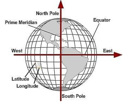
Latitude lines go from east to west, while Longitude lines run from north to south. Together, they create a grid system to locate any spot on the Earth.
LATITUDES
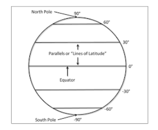
- The lines of Latitude are like circles that go around the Earth. They start at the Equator, which is 0 degrees, and go all the way up to 90 degrees at the North Pole and 90 degrees at the South Pole.
- If we draw these lines at intervals of 1 degree, we'll have 89 lines in each hemisphere, adding up to 179 lines in total. These lines run east to west and connect all points on Earth.
- The distance between two of these latitude lines is about 111 kilometres. So, all the lines of latitude are like a bunch of parallel hoops that go around the Earth, with the Equator as the starting point.

LONGITUDES
- Longitude is a way to measure distance on Earth, and it's measured in degrees. You can think of it as lines that run from the North Pole to the South Pole, passing through the Equator. These lines are often called meridians.
- Unlike the Equator, which is right in the middle between the poles, any of these meridians could have been chosen as the starting point for measuring longitude.
- But in 1884, countries around the world agreed to use the one that goes through the Royal Astronomical Observatory in Greenwich, near London. This is called the Prime Meridian (0°), and all other meridians are measured east or west from it, up to 180°.
- As you move from the Equator to the poles, the lines of latitude get shorter, and the lines of longitude come closer together, meeting at the poles.
- One really important job of these longitude lines is to help us figure out what time it is in different places. They're used to calculate local time in relation to Greenwich Mean Time (G.M.T.), which is often called World Time.

IMPORTANT PARALLELS OF LATITUDE
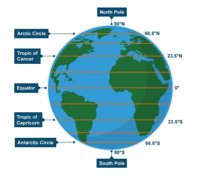
- Apart from the Equator (0°), the North Pole (90°N), and the South Pole (90°S), there are four significant lines of latitude:
- Tropic of Cancer (23½° N): This line is in the northern hemisphere, and it's located at 23.5 degrees north of the Equator.
- Tropic of Capricorn (23½° S): This line is in the southern hemisphere, and it's situated at 23.5 degrees south of the Equator.
- Arctic Circle (66½° N): This circle is approximately 66.5 degrees north of the Equator and is found in the northern hemisphere.
- Antarctic Circle (66½° S): The Antarctic Circle is situated around 66.5 degrees south of the Equator and is located in the southern hemisphere.
- These lines of latitude are essential for understanding and locating specific regions on Earth and for identifying the positions of the Tropics and the polar regions.

IMPORTANT MERIDIANS OF LONGITUDE
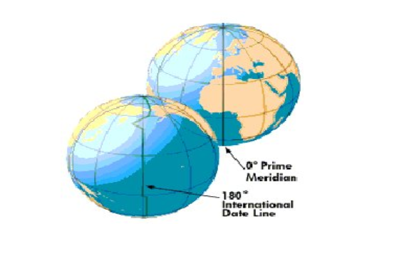
- The Prime Meridian is the line of longitude that serves as the starting point for measuring longitude. It's assigned a value of 0 degrees, and all other lines of longitude are measured east or west from this point. The Prime Meridian that's most widely used today passes through the Royal Observatory in Greenwich, near London, England.
- The International Date Line is an imaginary line that runs from the North Pole to the South Pole, primarily along the 180th meridian of longitude. It's the line that separates one calendar day from the next. When you cross the International Date Line from west to east, you lose a day, and when you cross it from east to west, you gain a day. It's used to account for differences in time as you travel around the world.

FAQs related to Latitude and Longitude
1. What is the purpose of latitude and longitude lines?
Ans. Latitude and longitude lines help us pinpoint locations on Earth's surface and measure distances accurately. They create a grid system to locate any spot on Earth.
2. How many latitude lines are there in each hemisphere?
Ans. If drawn at 1-degree intervals, there are 89 latitude lines in each hemisphere, totaling 179 lines.
3. What is the distance between two latitude lines?
Ans. The distance between two latitude lines is approximately 111 kilometers.
4. What is the Prime Meridian, and why is it significant?
Ans. The Prime Meridian is the line of longitude that serves as the starting point for measuring longitude. It has a value of 0 degrees, and all other lines of longitude are measured east or west from this point. The Prime Meridian passing through the Royal Observatory in Greenwich, England, is the one most widely used today.
5. What is the International Date Line, and what is its purpose?
Ans. The International Date Line is an imaginary line that runs from the North Pole to the South Pole along the 180th meridian of longitude. It separates one calendar day from the next. Crossing it from west to east results in losing a day, and crossing it from east to west means gaining a day. It helps account for time differences as you travel around the world.
6. What are the significant parallels of latitude on Earth?
Ans. Besides the Equator (0°), the North Pole (90°N), and the South Pole (90°S), there are four important lines of latitude: the Tropic of Cancer (23½° N), the Tropic of Capricorn (23½° S), the Arctic Circle (66½° N), and the Antarctic Circle (66½° S). These lines mark the positions of the Tropics and polar regions.
7. How do latitude and longitude lines affect time measurement?
Ans. Longitude lines help us calculate local time in relation to Greenwich Mean Time (G.M.T.), which is often referred to as World Time. This is crucial for determining time differences between various locations on Earth.
8. Why was the Prime Meridian located in Greenwich, near London?
Ans. In 1884, countries worldwide reached an agreement to use the Prime Meridian that passes through the Royal Observatory in Greenwich, near London, as the starting point for measuring longitude. This choice aimed to standardise measurements and timekeeping internationally.

