Local And Standard Time And The International Date Line
LOCAL TIME
- The time at a place, based on where the sun is in the sky, is called local time. This time is determined by when the sun is directly above that location. All places on the same meridian, an imaginary line running from the North Pole to the South Pole, experience noon at the same time.
- Since the Earth completes a full rotation of 360º in 24 hours, it rotates 15º every hour. This means it takes 4 minutes for the Earth to turn 1º.
- As the Earth rotates from west to east, places to the east see the sun earlier, so their time is ahead. In contrast, places to the west see the sun later, so they are behind in time.
- For example, if it's 12:00 pm at the Greenwich meridian (0º), it would be 12:04 pm at 1º east and 11:56 am at 1º west. Similarly, it would be 11:00 am at 15º west and 1:00 pm at 15º east.
As a result, each country has different local times, and the larger the east-west extent, the greater the differences in local times.
STANDARD TIME
- If each town used its own local time based on its meridian, there would be significant time differences between towns.
- Travellers going from one part of the country to another would constantly need to adjust their watches, which would be very inconvenient.To avoid this problem, countries use a system of standard time.
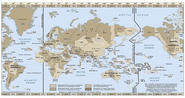
- Most countries choose their standard time based on the central meridian within their borders. However, in larger countries like Canada, the United States, China, and the former Soviet Union (U.S.S.R.), it's not practical to have just one time zone. So these countries have multiple time zones.
- For example, both Canada and the United States have five time zones: Atlantic, Eastern, Central, Mountain, and Pacific Time Zones. The time difference between the Atlantic and Pacific coasts is nearly five hours.
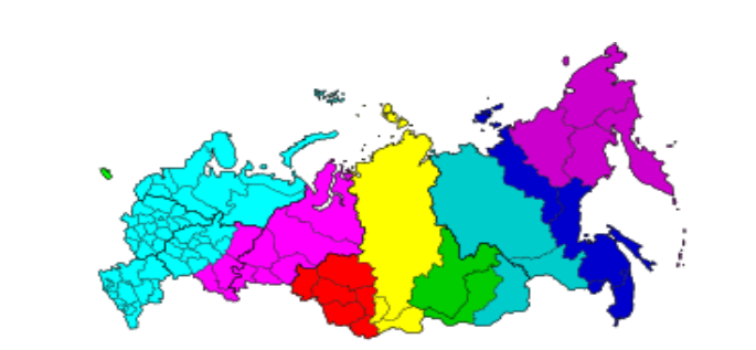
Also Russia now has nine time zones.

Today, Russia has nine time zones.
THE INTERNATIONAL DATE LINE
- When a traveller goes eastward from Greenwich, they gain time until they reach the 180°E meridian, at which point they will be 12 hours ahead of Greenwich Mean Time (G.M.T).
On the other hand, when travelling westward, they lose 12 hours when they reach the 180°W meridian.
- This results in a total time difference of 24 hours, which is equivalent to a whole day, between the two sides of the 180° meridian.
- This 180° meridian is known as the International Date Line.
It's the place where the date changes by exactly one day when crossed. When a traveller crosses the International Date Line from east to west, they lose a day because of the time difference. Conversely, when crossing from west to east, they gain a day due to the time difference.
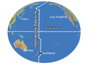
- The International Date Line in the mid-Pacific is not a straight line; it curves to accommodate certain islands. It deviates from the normal 180° meridian near the Bering Strait, Fiji, Tonga, and other islands to prevent confusion regarding the day and date. Some of these islands follow the time of Asia or New Zealand, while others use American date and time conventions.

INTERNATIONAL DATE LINE DRAWN IN ZIGZAG MANNER
The International Date Line (IDL) is located in the Pacific Ocean and is an imaginary line, just like longitudes and latitudes. On either side of this line, there is a time difference of 24 hours, which means that the date changes as soon as you cross it.
Some groups of islands, such as those in Polynesia, Melanesia, and Micronesia, are situated on different sides of the dateline. If the dateline were straight, it would result in two regions of the same island country or island group falling under different date zones.
To prevent such confusion, the IDL is drawn in a zig-zag manner, following the sea rather than the land. This ensures that the entire island or island group stays within the same date zone.

FAQs about Time and the International Date Line
1. What is local time?
Local time is the time at a specific place based on the position of the sun in the sky. It is determined by when the sun is directly overhead at that location. All places on the same meridian, an imaginary line from the North Pole to the South Pole, have noon at the same time.
2. How is local time related to Earth's rotation?
Since the Earth completes a full 360º rotation in 24 hours, it rotates 15º every hour. This means it takes 4 minutes for the Earth to turn 1º. As the Earth rotates from west to east, places to the east see the sun earlier, so their time is ahead, while places to the west see the sun later, so they are behind in time.
3. Why does each country have different local times?
Each country has different local times because they are spread across various meridians, and the Earth's rotation creates time differences between them. The larger the country's east-west extent, the greater the differences in local times within that country.
4. What is standard time, and why is it used?
Standard time is a system adopted by countries to have a consistent time within their borders. Most countries choose their standard time based on their central meridian. In large countries like Canada, the United States, China, and Russia, which span multiple meridians, multiple time zones are used to avoid inconvenient time differences.
5. What is the International Date Line (IDL)?
The International Date Line (IDL) is an imaginary line in the mid-Pacific Ocean. When travelling eastward from Greenwich, a person gains time until they reach the 180°E meridian, at which point they are 12 hours ahead of Greenwich Mean Time (G.M.T). Travelling westward, they lose 12 hours upon reaching the 180°W meridian. The IDL is the place where the date changes by one day when crossed.
6. Why is the IDL not a straight line?
The IDL is not a straight line because it accommodates certain groups of islands, such as those in Polynesia, Melanesia, and Micronesia. If it were straight, different parts of the same island country or group would fall under different date zones. To prevent confusion, the IDL follows the sea, making a zig-zag shape, ensuring the entire island or island group shares the same date zone.

